Download
3D Flyover
Add to list
More
2.5 km
~31 min
7 m
Loop
“A breezy loop to Millikin Falls—easy-going underfoot, with misty, slick surprises near the spray.”
A short, mostly level loop of about 3 km (1.9 mi) with roughly 0 m (0 ft) of climbing, this walk is ideal when you want a quick waterfall payoff without committing to a long day. Expect a mix of compacted path and narrower singletrack near the water, with a few short, potentially slick spots where spray and shade keep the ground damp.
Getting to the trailhead (car + public transport)
By car: Aim for the closest signed access to Millikin Falls within the Millikin Falls / Roberts Millikin Ditch area. In HiiKER, pull up the route and use the “Navigate to start” function to take you to the nearest legal parking pullout or small lot at the trailhead. Because access points here can be on minor roads, double-check in HiiKER that you’re heading to the correct side of the loop (some nearby spurs look similar on the ground).
By public transport: If you’re coming by bus/train, plan to get to the nearest town center or main road stop first, then use a short rideshare/taxi hop to the trailhead. In many rural waterfall areas, service can be infrequent and last runs can be early—confirm return options before you start. Once dropped off, use HiiKER to walk the final approach to the start point so you don’t accidentally begin on a parallel maintenance track.
(If you share the start coordinates/“near …” location, I can convert the lon/lat to the nearest recognizable address or landmark and tailor the directions precisely.)
You’ll typically start on an easy, obvious path that settles quickly into a gentle rhythm—no sustained climbs, no lung-busting grades. Within the first 0.5–1.0 km (0.3–0.6 mi) you’ll begin to hear water more consistently, especially after rain or during seasonal runoff. The loop format means you can visit the falls early and then cruise the remainder, or save the falls for the second half as a “finish-line” feature.
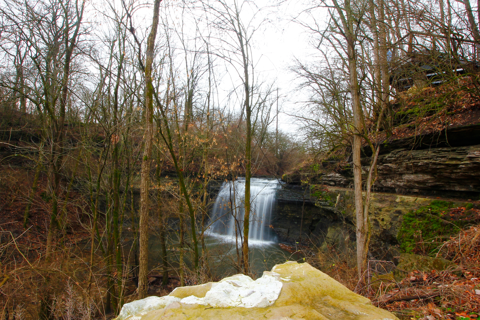
Millikin Falls: the main landmark
The falls area is the highlight and the place most likely to slow your pace. Plan extra time here even on a short hike—people naturally stop for photos and to pick a safe viewing angle. The immediate approach can include:
- Wet rock and slick roots near the spray zone
- Short, uneven footing where the trail narrows close to the creek edge
- Eroded edges where visitors have stepped off-trail to get closer to the water
Keep an eye out for informal side paths: they can look tempting but often lead to unstable banks. If you’re hiking with kids or anyone unsteady on their feet, this is the one section where close supervision matters most.
Roberts Millikin Ditch: what it is and why it’s here
The “ditch” portion of the loop typically follows or intersects an old water conveyance/irrigation or mill-related channel—a human-made feature built to move water efficiently along contour. These ditches were historically important in many regions for powering small mills, supporting early settlement, and later for irrigation and water management. On the ground, it often feels like a straighter, more engineered corridor than the falls-side trail: gentler grades, a more consistent tread, and occasional berms or cut banks that hint at its constructed origin.
Because these corridors were designed to carry water, they can also create:
- Soft, saturated edges after rain
- Mosquito pockets in still, shaded sections
- Hidden drop-offs where the ditch runs slightly below trail level
Stay on the main tread and avoid walking on the very lip of the channel where the soil can undercut.
Nature, terrain, and what to watch for
Even on an easy, low-elevation-gain loop, conditions can change quickly around water.
Trail surface: Mostly firm and friendly, with the slickest spots concentrated near the falls and any shaded ditch segments. After storms, expect small washouts or muddy patches—nothing major, but enough to make light hikers wish they’d brought shoes with better grip.
Wildlife: Water corridors commonly attract birds and small mammals. You may also encounter insects (especially near still water) and, depending on the broader region, the occasional snake basking on warm edges of trail. Give wildlife space, keep dogs close, and watch where you place hands if you step onto rocks or logs near the creek.
Plants: Riparian vegetation tends to be denser and greener near the falls. If the area has seasonal growth, narrow sections can brush your legs—long socks help if you’re sensitive to scratches or irritants.
Navigation and timing
For a 3 km (1.9 mi) easy loop, most hikers will take 45–90 minutes depending on how long they linger at the falls. Use HiiKER to:
- Confirm you’re on the correct loop direction at junctions
- Check distance remaining after the falls stop
- Avoid accidentally following maintenance tracks that parallel the ditch
Cell coverage can be inconsistent near drainages; download the route in HiiKER before you arrive.
Practical prep for an easy waterfall loop
- Footwear: Trail runners or light hikers with decent tread—grip matters more than ankle support here.
- Water: Even short hikes benefit from a bottle, especially in warm weather.
- Layers: Falls areas can feel cooler and damper; a light shell is useful if mist is blowing.
- Safety: Keep a buffer from ledges and slick rock near the falls; the hazard is slipping, not steep climbing.

Surfaces
Asphalt
Unknown
Concrete
Comments and Reviews
User comments, reviews and discussions about the Millikin Falls and Roberts Millikin Ditch Loop, Ohio.
average rating out of 5
0 rating(s)