Download
3D Flyover
Add to list
More
13.2 km
~2 hrs 58 min
203 m
Loop
“A gentle Cuyahoga Valley loop blends canal history, blue‑blazed woods, and a waterfall pause.”
This loop-style hike sits in the heart of Cuyahoga Valley National Park, mixing three very different walking experiences into one outing: a wide, nearly level canal towpath, a classic Ohio long-distance footpath segment (the Buckeye Trail), and a short spur to a waterfall overlook. At roughly 13 km (8.1 mi) with about 200 m (656 ft) of total climbing, it’s a solid “easy” day—mostly gentle grades, with the only real effort coming on the wooded connector sections where you leave the towpath and climb back out of the creek valley.
Getting to the start (car + public transport)
Best start point: Boston Mill Visitor Center, 6947 Riverview Rd, Peninsula, OH 44264. (conservancyforcvnp.org)
This is the most straightforward place to park, orient yourself, and step onto the Towpath/Buckeye connections used for Blue Hen Falls access. The National Park Service also notes Boston Mill Visitor Center (and nearby Boston Trailhead) as the primary parking options for hiking to Blue Hen Falls. (home.nps.gov)
- By car: Navigate to Boston Mill Visitor Center (6947 Riverview Rd, Peninsula, OH 44264). Parking fills quickly on fair-weather weekends—arrive early if you want a quieter start.
- By public transport: The most practical car-free approach is to combine regional transit to the Cleveland/Akron area with the Cuyahoga Valley Scenic Railroad (seasonal/service-dependent). The railroad lists a Boston Mill stop at 7100 Riverview Road, Peninsula, OH 44264, right by the visitor center area. Use HiiKER to confirm the walking connection between the depot and your chosen trailhead entrance. (en.wikipedia.org)
What the route feels like underfoot
You’ll spend a good portion of the day on the Ohio & Erie Canal Towpath Trail, a multi-use corridor that generally has a firm, crushed-limestone style surface and very mild grades—excellent for steady pacing and easy navigation. The Towpath follows the historic route where mules once walked to tow canal boats, and today it remains the signature through-route of the park. (nps.gov)
When you transition onto the Buckeye Trail, expect a narrower, more “hiker” feel—wooded tread, more roots and seasonal mud, and short rises/falls as the trail weaves through the Cuyahoga Valley’s side slopes. The Buckeye Trail is marked with blue blazes, and turns are typically indicated with a double blaze. (buckeyetrail.org)
For navigation, load the loop in HiiKER before you arrive and keep it handy at junctions where the towpath, connectors, and Buckeye segments intersect.
Key landmarks and highlights (with approximate distances)
0.0 km / 0.0 mi — Boston Mill Visitor Center area
Start near the visitor center and settle in quickly—this area is a hub for trails and park history. It’s also close to the historic canal corridor, so you’ll often see interpretive signs and remnants tied to the canal era.
~2–5 km / ~1.2–3.1 mi — Towpath cruising + canal history
On the Towpath, the walking is intentionally “easy miles.” This corridor is part of the broader Ohio & Erie Canalway landscape, where transportation and industry once depended on the canal system (1820s–early 1900s), and the modern trail was built to closely follow historic alignments and remnants. (ohioanderiecanalway.com)
Because it’s multi-use, stay alert for bikes—especially on weekends—and keep right on blind corners.
~5–7 km / ~3.1–4.3 mi — Transition to Buckeye Trail (more wooded, more up/down)
As you leave the towpath corridor, the hike becomes more enclosed and forested. This is where most of your 200 m (656 ft) of gain tends to accumulate in small chunks rather than one long climb. After rain or snowmelt, these shaded sections can hold mud and slick leaves longer than the towpath.
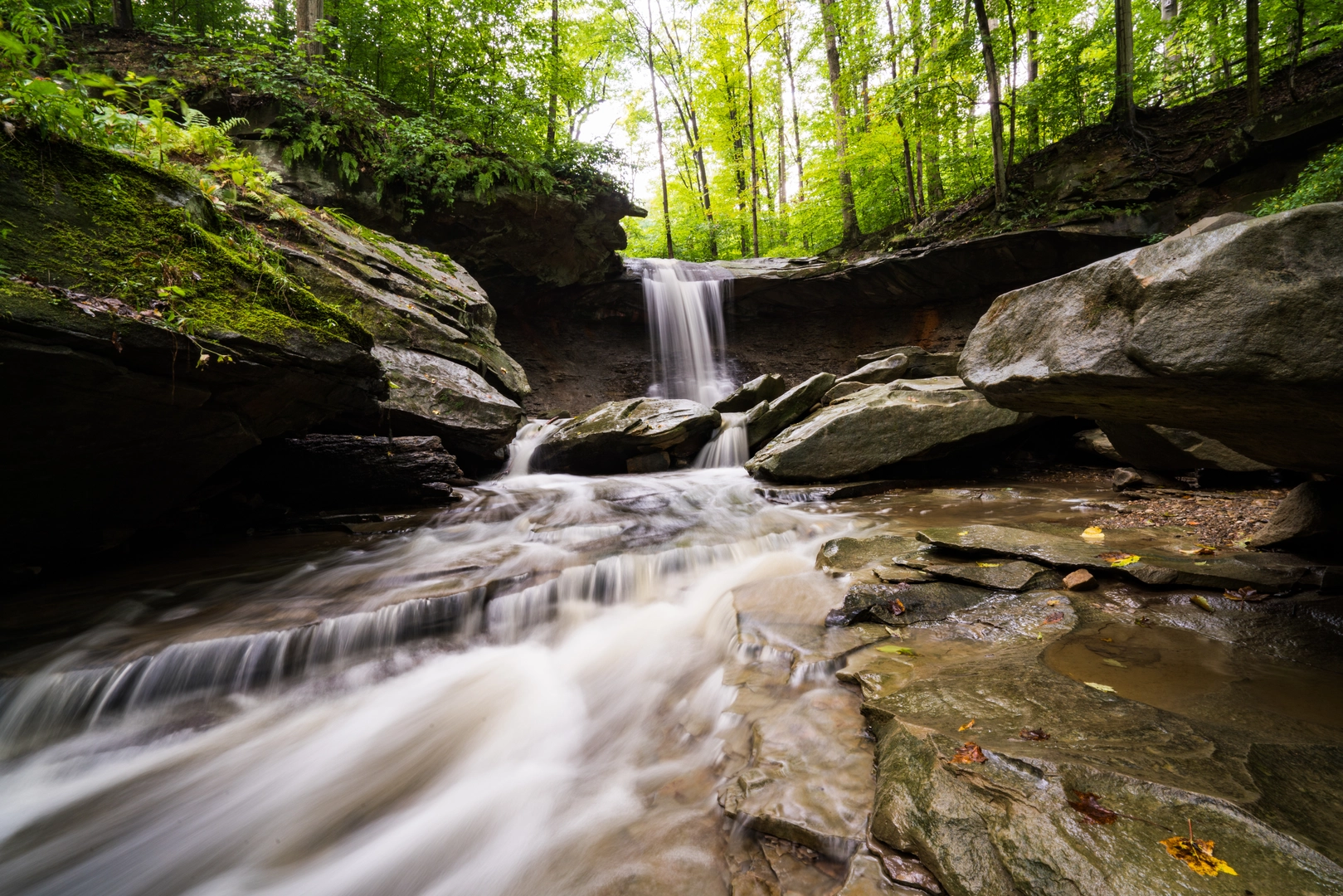
~7–8 km / ~4.3–5.0 mi — Blue Hen Falls overlook
Blue Hen Falls is a popular destination in the Boston

Surfaces
Dirt
Unknown
Unpaved
Wood
Asphalt
Gravel
Concrete
Ground
Comments and Reviews
User comments, reviews and discussions about the Blue Hen Falls via Buckeye Trail and Ohio and Erie Canal Towpath Trail, Ohio.
average rating out of 5
0 rating(s)