Download
3D Flyover
Add to list
More
4.2 km
~52 min
13 m
Out and Back
“A gentle bridle-path wander ends in a misty waterfall reward—watch for slick, rooty creekside footing.”
This easy out-and-back (or short loop, depending on how you turn around) is a gentle 4 km / 2.5 mi walk with essentially flat overall elevation change (about 0 m / 0 ft net gain). It’s ideal when you want a waterfall payoff without committing to steep climbs, and it stays approachable for families and newer hikers—just expect a few short, uneven sections near the creek and falls where footing can get slick.
Getting to the trailhead (car + public transport)
Because the hike head location is listed only as “near” (with no coordinates or town/park name), the best I can do is describe how to plan your approach once you identify the correct “Berea Falls” in your region:
- By car: In HiiKER, open the route and tap the trailhead/parking pin. Use the pin’s location to navigate to the nearest signed parking area (often labeled as a trailhead lot, picnic area, or nature reserve parking). If the falls are inside a park or reserve, check for day-use gates and closing times—waterfall areas commonly close at dusk.
- By public transport: Use HiiKER to identify the nearest road access point, then look for the closest bus stop or rail station to that access road. Waterfall trailheads are frequently a “last-mile” problem—plan for a short rideshare or a 1–3 km (0.6–1.9 mi) road walk if transit doesn’t reach the parking area.
If you share the lon/lat (or a HiiKER link), I can convert it to the nearest known address or landmark and give exact, practical directions.
What the walk is like (surface, landmarks, and pacing)
From the trailhead, the Bridle Trail typically starts wide and forgiving—often a double-track path originally intended for horses or service access. Over the first 1 km / 0.6 mi, expect a steady, easy rhythm on packed dirt or fine gravel with minimal grade. Even with “0 m” overall gain, you may notice small rollers: shallow dips toward drainage lines and gentle rises back to the main bench.
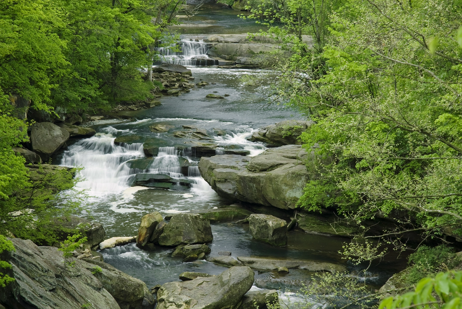
As you get closer to the watercourse (usually around 1.5–2 km / 0.9–1.2 mi in on a 4 km / 2.5 mi outing), the corridor often narrows and becomes more rooty. Listen for the sound of moving water before you see it—falls areas tend to announce themselves with a low roar, especially after rain.
The final approach to Berea Falls is usually the most “technical” part of an otherwise easy hike: - Footing: damp rock, mud patches, and exposed roots are common. - Edges: informal viewpoints can be undercut or crumbly—give the lip space, especially with kids. - Spray zone: if the falls are flowing well, the rocks nearest the base can be slick like ice.
Plan roughly 45–90 minutes total moving time for most hikers on 4 km / 2.5 mi, depending on how long you linger at the falls.
Nature, wildlife, and what to look out for
Waterfall trails concentrate life: moisture-loving plants, birds drawn to insects, and amphibians where the creek slows.
- Plants: Expect ferns, mosses, and other shade-tolerant greenery near the creek and in the spray zone. In warmer months, look for wildflowers along sunnier edges of the bridle path.
- Wildlife: Small songbirds are common along the corridor; near water you may spot frogs or salamanders (often tucked under rocks or in leaf litter). Larger mammals tend to be shy but may leave tracks in soft mud.
- Bugs: In still, humid conditions, mosquitoes and biting flies can be noticeable near water—pack repellent in summer.
- Seasonal hazards: After heavy rain, creekside sections can flood or turn to deep mud; in colder months, shaded wet rock can hold frost or thin ice even when the rest of the trail feels mild.
Navigation and safety notes (keep it easy)
Even on a short route, waterfall areas often have social trails—unofficial spurs that lead to risky overlooks or dead ends. Use HiiKER to stay on the Bridle Trail line and confirm you’re taking the intended spur to the falls rather than a parallel track.
Bring: - shoes with decent tread (the falls area is the crux), - a light rain layer (spray + sudden showers), - at least 0.5–1 L of water per person for a short outing, - a small first-aid kit for slips/scrapes.
Historical context to watch for
“Bridle Trail” names often reflect older land use—routes created for horses, farm access, forestry, or early recreation before modern trail standards. Near falls, you may also see signs of historic water use (old stonework, remnants of small dams/weirs, or cut banks from past logging). If this Berea Falls is within a formally managed reserve, interpretive signage near the main viewpoint sometimes highlights local settlement history, indigenous land stewardship, or the area’s role in early industry tied to waterways.
If you provide the exact location (lon/lat) for this Berea Falls, I can pin down the nearest address/landmark for the start, identify the most likely historical themes for that specific region, and call out any known closures, fees, or seasonal constraints.

Surfaces
Gravel
Unknown
Asphalt
Wood
Comments and Reviews
User comments, reviews and discussions about the Berea Falls via Bridle Trail, Ohio.
average rating out of 5
0 rating(s)