Download
3D Preview
Add to list
More
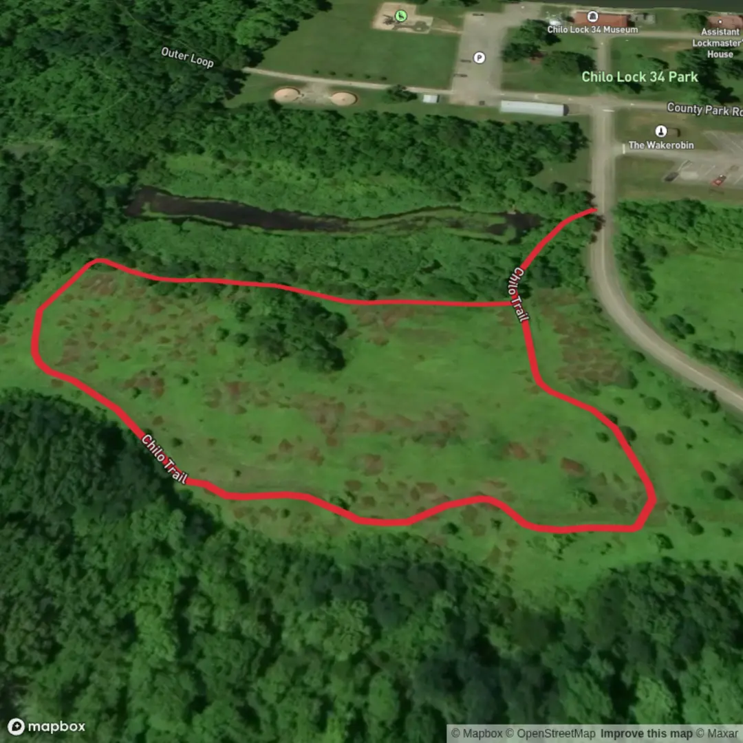
587 m
~7 min
0 m
Loop
“A gentle, mostly flat nature loop—pause for birdsong, wetland glimmers, and interpretive surprises.”
A short, mostly level loop of about 1 km (0.6 mi) with essentially 0 m (0 ft) of climbing, this is the kind of walk that works well for families, beginners, a quick leg-stretcher, or anyone wanting an easy nature loop without committing to a longer outing. Expect a relaxed pace: most hikers will take 15–30 minutes depending on stops for photos, wildlife watching, or reading any on-site signage.
Getting to the trailhead (car + public transport)
I’m missing the key location detail (“Hike head: near …” is incomplete), so I can’t reliably convert the trailhead coordinates to the nearest address/landmark or give accurate directions yet.
If you share either:
- the longitude/latitude of the start point, or
- a town/park name, or
- a HiiKER link to the route,
…I’ll translate that into the nearest recognizable address/landmark and give specific driving and public-transport options.
In the meantime, for a 1 km park-style loop, the start is commonly at a small parking pull-in, picnic area, or park entrance kiosk. If you’re driving, plan for limited parking capacity and consider arriving earlier on weekends. If you’re using public transport, these short loops are often easiest when there’s a bus stop within 0.5–1.5 km (0.3–0.9 mi)—otherwise rideshare/taxi for the last mile can be the practical option.
What the walk is like underfoot
With negligible elevation change, the main “difficulty” factors won’t be hills—they’ll be surface conditions and trail width:
- Surface: often compact dirt, fine gravel, or short sections of boardwalk/pavers in wetter spots. After rain, watch for slick mud, shallow puddling, and soft edges where the ground can give way.
- Width & flow: easy loops like this can be narrow in places if vegetation encroaches, but they’re usually straightforward to follow. If there are intersecting side paths, confirm your loop direction using HiiKER so you don’t accidentally cut the loop short.
- Accessibility: “flat” doesn’t always mean stroller- or wheelchair-friendly—roots, sand, or muddy patches can still be a barrier. If you need an accessibility check, the exact location will let me advise more accurately.
Landmarks and points of interest to watch for
On a loop this short, the highlights tend to be small, close-up features rather than big vistas. Typical points of interest you may encounter include:
- Interpretive signs (local plants, birds, or habitat restoration notes)
- Wetland edges or seasonal drainage (often the best wildlife viewing)
- A small footbridge/culvert where you can pause and look for aquatic life
- Mature “signature” trees (large trunks, distinctive bark, or canopy openings)
If you provide the trailhead location, I can call out the most likely “must-not-miss” spots along the loop with approximate distances like 0.2 km (0.1 mi) to the first habitat change, 0.5 km (0.3 mi) to the best viewing point, etc.
Nature and wildlife (what to look out for)
Easy, low-elevation loops are often built through edge habitat—where forest meets meadow, wetland meets scrub, or parkland meets riparian corridor. That’s great for variety in a short distance.
What hikers commonly see on short loops like this: - Birdlife: songbirds in shrubs, woodpeckers in mature trees, and waterbirds if there’s a pond/creek nearby. Early morning is usually most active. - Small mammals: squirrels, rabbits, chipmunks; occasionally deer in quieter areas. - Reptiles/amphibians: lizards on sunny trail margins; frogs/toads near damp ground. - Insects: in warm months, expect mosquitoes/gnats near standing water—bring repellent if you’re sensitive.
What to look out for: - Ticks in grassy edges and leaf litter—wear long socks, do a quick check after. - Poison ivy/oak depending on region—avoid brushing against shiny three-leaf clusters. - Stinging insects around flowering plants or fallen logs—step carefully if you hear buzzing. - Dogs/other trail users: short loops can be busy; keep right and be ready for quick passes.
Planning notes (what to bring for a 1 km easy loop)
Even on a very short hike, a few basics make it smoother: - Footwear: sneakers are usually fine; choose something with grip if it’s wet. - Water: at least a small bottle, especially in heat/humidity. - Sun/rain protection: hat + sunscreen for open sections; a light shell if weather is changeable. - Navigation: if there are multiple intersecting paths, keep HiiKER handy to confirm you’re staying on the loop.
Historical significance (how I’ll tailor this once I have the location)
“Chilo Loop Trail” could exist in more than one region, and historical context is highly place-specific. Once you share the start coordinates or nearest town/park, I can accurately describe: - Indigenous/First Nations/Tribal connections to the landscape (where appropriate and documented) - Local land-use history (logging, ranching, mining, agriculture, watershed management) - Any protected-area or restoration story (wetland rehabilitation, reforestation, wildlife corridor work) - Notable nearby historic sites (old rail grades, homesteads, forts, or cultural landmarks)

Surfaces
Unpaved
Unknown
Comments and Reviews
User comments, reviews and discussions about the Chilo Loop Trail, Ohio.
average rating out of 5
0 rating(s)