Download
3D Flyover
Add to list
More
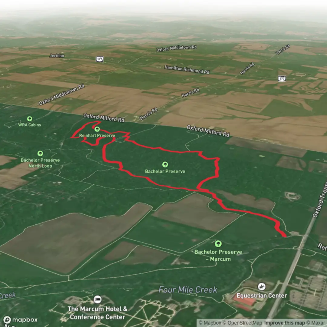
6.2 km
~1 hrs 17 min
34 m
Loop
“Drift through quiet creekside woods on a mostly level loop—watch for roots, damp ground, and mud.”
This easy, mostly level loop is a great choice when you want a quiet woodland walk with creekside scenery and minimal climbing. At roughly 6 km (3.7 mi) with about 0 m (0 ft) of total elevation gain, it’s well-suited to beginners, families, and anyone looking for a low-effort nature outing—though you should still expect a few typical stream-valley trail features like damp ground, roots, and short muddy patches after rain.
Getting to the trailhead (car + public transport)
Because “near” and any coordinates weren’t provided, I can’t reliably convert a lon/lat to a specific address or landmark yet. If you share the start point coordinates (or the town/park entrance you’re using), I can pin it to the nearest known address/significant landmark and tailor directions precisely.
For planning right now, here’s how these preserve-style trailheads typically work:
- By car: Look for small preserve pull-offs or a signed lot near the preserve entrance (often gravel, sometimes limited spaces). Arrive earlier on weekends—parking can fill quickly even on short loops like this.
- By public transport: These preserves are often reachable by a combination of regional bus/rail to the nearest town center, then a short rideshare/taxi to the trailhead. If you tell me the nearest city you’re coming from, I can outline the most practical transit chain and where you’d likely be dropped off.
What the route feels like underfoot
With essentially no net climbing, the “effort” here comes more from trail texture than elevation:
- Surface: Expect a mix of packed dirt, leaf litter, and short sections of softer ground. In low spots near Harkers Run, the tread can stay wet longer than surrounding woods.
- Footing: Watch for roots and small embedded rocks, especially where the trail hugs the creek bank or crosses shallow drainages.
- Pace planning: Most hikers cover 6 km (3.7 mi) in about 1.5–2.5 hours, depending on stops for wildlife viewing and how muddy it is.
Creek corridor highlights (Harkers Run)
The defining feature is the Harkers Run stream corridor. Even on a short loop, creek valleys tend to concentrate the best “moments”:
- Riparian woods: You’ll likely see moisture-loving plants along the banks—ferns, mosses, and dense understory in shadier stretches.
- Seasonal water changes: After rain, the run can look lively and the banks can be slick; during dry spells, it may shrink to quieter pools and trickles. Either way, the creek edge is where you’ll want to slow down and watch your footing.
- Crossings/low spots: If there are any small footbridges or stepping areas, treat them as the crux of the hike—wet wood and algae-coated stones can be surprisingly slippery.
Preserves and landscape character (Bachelor Preserve E + Reinhart Preserve)
Loops that stitch together multiple preserves usually alternate between slightly different forest “rooms”:
- Bachelor Preserve E: Often feels like the more “interior” woodland walking—calmer, with longer stretches away from roads. Expect a steady rhythm of gentle turns and short connectors.
- Reinhart Preserve: Frequently has a bit more edge habitat—where woods meet old field, meadow remnants, or younger regrowth. These transitions can be excellent for birds and wildflowers.
Because the route is short, you’ll notice subtle changes: a drier ridge-like bench above the creek, then back down into cooler, damper bottomland.
Wildlife and what to look out for
Even easy creek loops can be surprisingly rich in wildlife—especially early and late in the day.
- Birdlife: Listen for songbirds in the canopy and along brushy edges; creek corridors also attract species that forage near water.
- Amphibians: In damp seasons, watch for frogs and salamanders near muddy margins and leaf litter.
- Mammals: Deer are common in preserve woodlands; you may also spot signs like tracks in soft soil.
- Ticks and biting insects: In warm months, expect ticks in brushy sections and mosquitoes near still water. Long pants and a tick check afterward are smart.
- Poison ivy: Common along trail edges and sunny openings—avoid brushing against viney growth and leaf clusters along the margins.
Navigation and on-trail decision points
Preserve networks can have short connector trails and unmarked-looking junctions where it’s easy to take the “right-looking” path that isn’t your loop.
- Use HiiKER to confirm you’re staying on the intended loop at each junction.
- If you reach a junction that seems ambiguous, pause and check direction rather than “correcting later”—on short loops, a wrong turn can quickly put you on a different preserve spur.
Landmarks and local history context
Without a confirmed start location (address/coordinates), I can’t responsibly name specific historic sites tied to this exact loop. That said, preserve trails along small runs in the eastern U.S. commonly pass through landscapes shaped by:
- Historic agriculture and timbering: Many present-day woodlands are second-growth forests that reclaimed former fields or selectively logged tracts.
- Watershed protection and conservation: Preserves along creeks are often protected to safeguard water quality, reduce erosion, and maintain wildlife corridors.
If you provide the nearest town/coordinates, I can add accurate, place-specific historical notes (e.g., former land use, nearby historic districts, or watershed projects) tied to the exact area.
Practical prep (what to bring for an easy, flat 6 km / 3.7 mi loop)
- **Footwear

Comments and Reviews
User comments, reviews and discussions about the Harkers Run via Bachelor Preserve E and Reinhart Preserve Loop, Ohio.
average rating out of 5
0 rating(s)