Download
3D Flyover
Add to list
More
140.3 km
7 days
1942 m
Multi Day
“Embark on St Patrick's Way, a historical and scenic pilgrimage across Northern Ireland's majestic landscapes.”
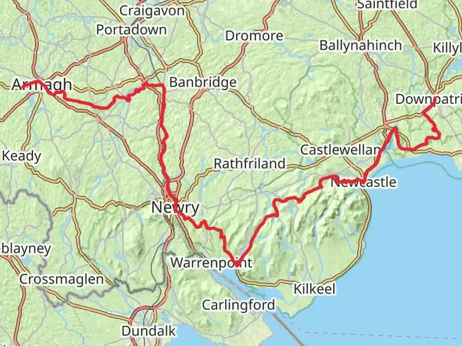
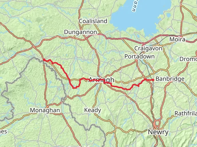
St Patrick's Way, also known as The Pilgrim's Walk, is a captivating journey through the heart of Northern Ireland, stretching approximately 140 kilometers (about 87 miles) with an elevation gain of around 1600 meters (approximately 5249 feet). This point-to-point trail invites hikers to traverse a path steeped in history and natural beauty, connecting key sites associated with Saint Patrick and offering a medium difficulty rating that makes it accessible to a wide range of walkers.
Getting to the Trailhead The trailhead for St Patrick's Way is situated near County Armagh, easily accessible by both public transport and car. For those opting for public transport, buses and trains serve the nearby towns, and from there, local buses can get you closer to the starting point. If driving, parking is available in the vicinity of the trailhead. Utilizing HiiKER for navigation will help in pinpointing the exact starting location and planning your route to it.
Historical Significance and Landmarks Embarking on this trail is not just a physical journey but a historical pilgrimage, taking you through areas of significance in the life of Ireland's patron saint, Saint Patrick. The route is dotted with ancient monasteries, high crosses, and cathedrals. Notably, the trail passes through the city of Armagh, known as the ecclesiastical capital of Ireland, where you can visit both the Roman Catholic and Church of Ireland cathedrals dedicated to Saint Patrick.
Natural Beauty and Wildlife As you progress along St Patrick's Way, the landscape unfolds with a mix of rolling hills, serene lakes, and lush green countryside. The trail offers a chance to immerse yourself in the tranquility of rural Northern Ireland, with opportunities to spot local wildlife such as deer, badgers, and a variety of bird species. The Mourne Mountains provide a stunning backdrop, especially as you approach the latter stages of the hike.
Trail Experience and Navigation The trail is well-marked, and with the aid of HiiKER, navigation should be straightforward. However, it's always wise to carry a physical map and compass as a backup. The terrain varies, with some sections passing through quiet country roads, forest paths, and open countryside. Footwear with good support and grip is recommended, as some areas can be muddy, particularly after rain.
Preparation and Planning Given the trail's length, planning overnight stops is essential. There are several towns and villages along the route where accommodation can be found. It's advisable to book in advance, especially during peak seasons. Water sources are available, but carrying enough water and a means to purify it is recommended. As for food, there are places to restock supplies, but carrying enough snacks and meals for the day's hike is prudent.
Weather and Safety The weather in Northern Ireland can be unpredictable, so hikers should be prepared for rain and changes in temperature. Layered clothing, waterproof gear, and a hat are essential. Safety is paramount, so let someone know your plans, check the weather forecast, and be aware of your physical limits.
Conclusion St Patrick's Way offers a unique blend of cultural heritage and natural splendor. Whether you're seeking spiritual reflection, historical exploration, or simply the joy of a long-distance hike through picturesque landscapes, this trail provides an enriching experience that resonates long after the journey is complete.
AI Planner
Days planned around your pace, with somewhere to stay each night.

What to expect?
Activity types
Surfaces
Asphalt
Unknown
Gravel
Unpaved
Grass
Wood
Concrete
Paved
Sand
Dirt
Comments and Reviews
User comments, reviews and discussions about the St Patrick's Way, Northern Ireland.
4.62
average rating out of 5
21 rating(s)