Download
3D Flyover
Add to list
More
7.9 km
~2 hrs 3 min
286 m
Point-to-Point
“Embark on a captivating, moderately challenging hike through Appalachian history and vibrant natural beauty.”
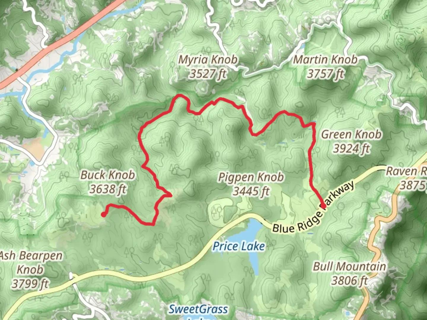
Starting near Watauga County, North Carolina, the Old John's River Road and Boone Fork Trail offers a captivating journey through the Appalachian landscape. This point-to-point trail spans approximately 8 kilometers (around 5 miles) with an elevation gain of about 200 meters (656 feet), making it a moderately challenging hike suitable for those with some hiking experience.
Getting There
To reach the trailhead, you can drive or use public transportation. If driving, head towards the Julian Price Memorial Park, located off the Blue Ridge Parkway near Blowing Rock, NC. The nearest significant landmark is the Julian Price Campground, which serves as a convenient starting point. For those using public transport, the nearest bus stop is in Boone, NC, from where you can take a taxi or rideshare service to the trailhead.
Trail Overview
The trail begins with a gentle ascent through dense hardwood forests, offering a serene start to your hike. As you progress, you'll encounter a mix of terrains, including rocky paths and soft forest floors. The first significant landmark is the Boone Fork, a picturesque stream that meanders through the forest. At around 2 kilometers (1.2 miles) in, you'll cross a wooden footbridge over the Boone Fork, providing an excellent spot for a quick rest and some photos.
Historical Significance
This area is steeped in history, with Old John's River Road being an ancient route used by early settlers and Native Americans. The trail itself follows parts of this historic road, offering a glimpse into the past as you hike along paths that have been trodden for centuries.
Flora and Fauna
The trail is rich in biodiversity. In the spring and summer, you'll find a variety of wildflowers, including trillium and rhododendron. Keep an eye out for wildlife such as white-tailed deer, wild turkeys, and the occasional black bear. Birdwatchers will also enjoy spotting species like the Eastern Bluebird and the Red-tailed Hawk.
Key Sections
- Boone Fork Falls: Around the 4-kilometer (2.5-mile) mark, you'll reach Boone Fork Falls, a stunning waterfall that cascades over a series of rock ledges. This is a great spot to take a break and enjoy the natural beauty.
- Rocky Outcrops: As you continue, the trail becomes rockier, with several outcrops offering panoramic views of the surrounding mountains. These sections require careful footing, especially after rain when the rocks can be slippery.
- Meadow Section: Near the end of the trail, you'll pass through a beautiful meadow, which is particularly vibrant in the late spring and early summer. This area is perfect for a leisurely stroll and offers a stark contrast to the dense forest sections.
Navigation and Safety
Given the varied terrain, it's advisable to use a reliable navigation tool like HiiKER to stay on track. The trail is well-marked, but having a digital map can be very helpful, especially in the more remote sections. Always carry sufficient water, snacks, and a basic first-aid kit. Weather can change rapidly in this region, so pack layers and be prepared for sudden rain showers.
Final Stretch
The trail concludes near the Price Lake, another scenic spot where you can relax and reflect on your hike. From here, you can either arrange for a pickup or hike back to the starting point if you're up for a longer trek.
This trail offers a perfect blend of natural beauty, historical significance, and moderate challenge, making it a rewarding experience for any hiker.

What to expect?
Activity types
Comments and Reviews
User comments, reviews and discussions about the Old John's River Road and Boone Fork Trail, North Carolina.
4.44
average rating out of 5
9 rating(s)