Download
3D Flyover
Add to list
More
692 m
~10 min
22 m
Out and Back
“A brief, mossy gorge wander to Wolf Creek Cascade—small in distance, big on slippery wonder.”
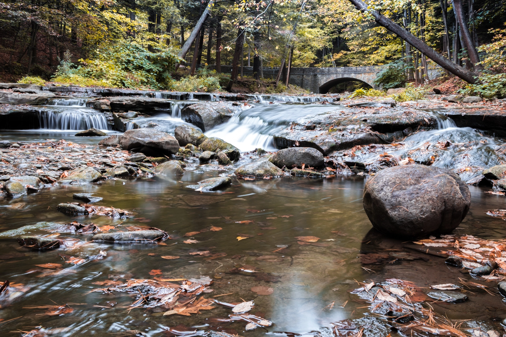
Wolf Creek Cascade via the Gorge Trail is a short, scenic out-and-back-style walk (or short loop depending on the exact junctions you choose) that packs a lot into roughly 1 km / 0.6 mi with essentially 0 m / 0 ft of net elevation gain. Even with the modest stats, the “Medium” feel usually comes from slick gorge footing, wet rock, roots, and narrow tread rather than steep climbing—plan for slow, careful steps.
Before I can convert the start location to the nearest address/landmark and give truly accurate access notes, I need one missing piece: the trailhead coordinates (lon/lat) or at least the state/province + nearest town/park. “Wolf Creek Cascade” and “Gorge Trail” are names used in multiple places.
If you send the lon/lat (or a map screenshot), I’ll tailor everything precisely. In the meantime, here’s how to plan for a 1 km gorge-to-waterfall hike like this, what to expect on the ground, and what to watch for.
What the hike feels like (distance, pacing, and terrain)
- Distance: ~1 km / 0.6 mi total (often 0.5 km / 0.3 mi each way if it’s a straight out-and-back to the cascade).
- Elevation: ~0 m / 0 ft net gain, but expect small undulations (little dips and rises) that don’t show up well in simple totals.
- Time estimate: Many hikers finish in 20–45 minutes, but it can take longer if you’re moving cautiously on wet rock or stopping at viewpoints.
- Footing: Typical gorge-trail surfaces include:
- Packed dirt transitioning quickly to roots, cobble, and bedrock
- Boardwalks/bridges in wetter sections (often slick with algae)
- Narrow bench-cut tread above the creek where a slip could mean a wet landing or a bump on rocks
- Why it can rate “Medium”: short distance doesn’t equal easy—traction and balance matter more than fitness here.
Landmarks and what to look for along the way
You’ll usually encounter these features in a predictable sequence on a gorge approach:
- Trailhead entry & riparian corridor (first ~0.2 km / 0.1 mi): The path often starts in mixed second-growth forest and quickly drops into a cooler, damper creekside microclimate. Look for mossy boulders, ferns, and water-polished stone.
- Gorge pinch points (~0.3–0.6 km / 0.2–0.4 mi): The walls tighten and the sound of moving water increases. This is where the tread can narrow and where you’ll most often find slick rock slabs or root ladders.
- Wolf Creek Cascade viewpoint/arrival (~0.5 km / 0.3 mi one-way): The cascade is typically best viewed from a rocky apron or a small bank-side opening. Expect spray in higher flow seasons; keep electronics and lenses protected.
If there are any unsigned junctions, use HiiKER to confirm you’re staying on the Gorge Trail alignment—short waterfall spurs sometimes braid into social paths near the falls.
Hazards and “Medium” difficulty factors (what to watch out for)
- Slippery surfaces: Wet bedrock, algae-coated boardwalk, and polished stones are the #1 reason people slip. Shoes with sticky rubber and defined lugs help.
- High water & undercut banks: After rain or snowmelt, the creek can rise fast. Avoid stepping onto overhanging edges that can collapse.
- Rooty steps: Roots can be ankle-twisters, especially when hidden under leaves.
- Falling debris: In narrow gorges, wind or freeze-thaw can knock down small branches or loosen rock. Don’t linger directly beneath steep, fractured walls.
- Cold, damp microclimate: Even on warm days, gorges can feel cooler. A light layer can be useful if you stop for long at the falls.
Nature and wildlife you may encounter
Gorge trails concentrate moisture, so plant life is often lush: - Mosses, liverworts, and ferns thrive on shaded rock faces. - Riparian shrubs and moisture-loving trees (species depend on region) often line the creek. - In many North American gorge corridors, you may see: - Songbirds and woodpeckers in the canopy - Amphibians (salamanders/newts) near seeps and wet leaf litter—watch your footing and avoid handling them - Insects near still pools; in warmer months, consider repellent
If this hike is in bear country, treat it like any short forest walk: make noise on blind corners, keep food secured, and give wildlife space.
Seasonal timing and waterflow expectations
- Best waterfall flow: commonly late winter through spring and after sustained rain.
- Lowest flow: often late summer/early fall, when the cascade may be thinner but the rocks can be drier (still slick in shade).
- Winter: ice can form on shaded rock and steps; traction devices may be warranted if temperatures hover around freezing.
What to pack for a 1 km gorge waterfall hike
Even though it’s short, the environment can be technical: - Footwear: trail shoes or light boots with good grip - Layers: a light shell if spray or drizzle

Surfaces
Unknown
Ground
Wood
Comments and Reviews
User comments, reviews and discussions about the Wolf Creek Cascade via Gorge Trail, New York.
average rating out of 5
0 rating(s)