Download
3D Flyover
Add to list
More
44.1 km
~2 days
189 m
Multi-Day
Old Croton Aqueduct Trail
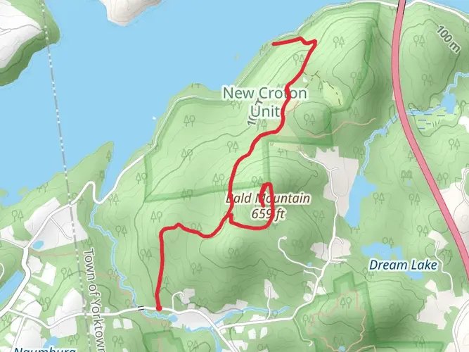
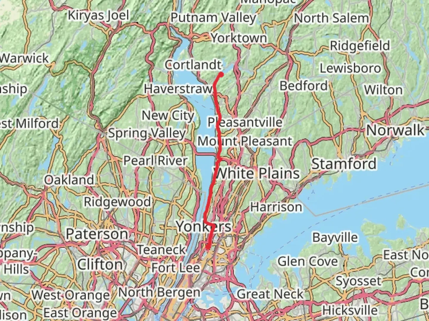
The Old Croton Aqueduct Trail, a historical gem, stretches approximately 44 kilometers (about 27 miles) and boasts a modest elevation gain of around 100 meters (328 feet). This point-to-point trail is nestled near Westchester County, New York, and is rated with a medium difficulty level, making it accessible to hikers with a moderate level of experience.
Getting to the Trailhead
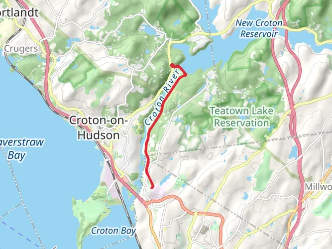
The trailhead is conveniently located near the Croton Dam and Croton Gorge Park, which is accessible by car. For those opting for public transportation, one can take the Metro-North Railroad from Grand Central Terminal in New York City to the Croton-Harmon station. From there, a taxi or a local bus can be taken to reach the trailhead.
Navigating the Trail
Hikers can utilize the HiiKER app to navigate the trail, ensuring they stay on the correct path and can easily locate points of interest along the way. The trail is well-marked, but having a digital tool can enhance the hiking experience and provide peace of mind.
Historical Significance
The Old Croton Aqueduct was constructed in the 1840s to bring fresh water to New York City. As you hike along the trail, you'll be walking atop the original aqueduct, which is now a historic state park. The trail offers a unique blend of natural beauty and a glimpse into the engineering marvels of the 19th century.
Landmarks and Surroundings
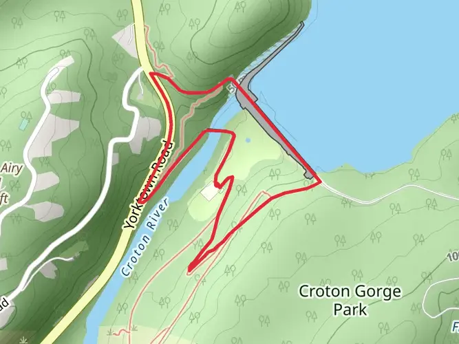
One of the most significant landmarks you'll encounter is the Croton Dam, which marks the northern end of the trail. The dam itself is an impressive structure, and the views of the cascading water are a highlight for many hikers.
As you progress southward, you'll pass through a variety of landscapes, including wooded areas, small towns, and suburban backyards. The trail is a green corridor that provides a haven for wildlife. Keep an eye out for deer, birds, and other local fauna that inhabit the region.
Nature and Wildlife
The trail is lined with a mix of deciduous trees, and depending on the season, you may witness the vibrant colors of fall foliage or the fresh blooms of spring. The canopy provides shade in the summer months, making for a pleasant hiking experience.
Preparation and Planning
Before embarking on your hike, ensure you have adequate water and snacks, as there are limited facilities along the trail. Wear sturdy footwear and dress in layers to adapt to changing weather conditions. It's also wise to check the weather forecast and trail conditions beforehand.
Remember that the trail is shared with joggers, cyclists, and sometimes horseback riders, so be prepared to encounter a variety of trail users. As always, practice Leave No Trace principles to help preserve the beauty and integrity of the trail for future visitors.
Whether you're interested in the historical aspects, the natural beauty, or simply looking for a pleasant day hike near New York City, the Old Croton Aqueduct Trail offers a unique and enjoyable outdoor experience.

Frequently asked questions
How long is the Old Croton Aqueduct Trail and how many days does the full hike take?
The Old Croton Aqueduct Trail is 44.13 kilometers, or about 27.4 miles, end to end through Westchester County. With only 189 meters of elevation gain, many hikers split it into two easy days, while strong walkers often complete it as a long single-day point-to-point route.
Is the Old Croton Aqueduct Trail difficult, and is it good for beginners?
The Old Croton Aqueduct Trail is generally considered easy, with a very gentle grade because it follows the line of the historic aqueduct. The route gains only 189 meters over 44.13 kilometers, so the main challenge is distance rather than steep climbing or technical terrain.
Where can you park for the Old Croton Aqueduct Trail in Westchester County?
One of the best-known access points for the Old Croton Aqueduct Trail is Croton Gorge Park near the northern end. New York State Parks lists parking there and notes a seasonal parking fee of $10 per car from May through Labor Day, making it a practical place to start a north-to-south hike.
Can you reach the Old Croton Aqueduct Trail by train from New York City?
Yes. Metro-North’s Hudson Line provides useful access to the Old Croton Aqueduct Trail, with Croton-Harmon serving the northern end and several river towns along the route also close to the trail. New York State Parks notes Croton-Harmon is about a 15-minute taxi ride from Croton Gorge Park, and Metro-North highlights multiple Hudson Line stations near the trail.
What is the trail surface like on the Old Croton Aqueduct Trail?
Most of the Old Croton Aqueduct Trail is known for a hard-packed dirt surface, which helps explain its easy rating and steady footing. Some sections also pass through village streets or use mixed surfaces, especially farther south, so the route feels more like a historic greenway than a remote backcountry trail.
What landmarks do you see on the Old Croton Aqueduct Trail?
The Old Croton Aqueduct Trail follows the route of the 1840s waterworks that carried fresh water from the Croton River toward New York City. Along the way, hikers pass features tied to that system, including the Croton Dam area at the north end and the aqueduct’s distinctive ventilator shafts, which appear at intervals along the route.
Is the Old Croton Aqueduct Trail a good hike for a low-elevation long walk in Westchester County?
Yes. The Old Croton Aqueduct Trail is unusually gentle for its length, covering 44.13 kilometers with just 189 meters of elevation gain. That makes it a strong option for hikers who want a long-distance day hike or overnight walk in Westchester County without major climbs.
Comments and Reviews
User comments, reviews and discussions about the Old Croton Aqueduct Trail, New York.
4.86
average rating out of 5
7 rating(s)