Download
Preview
Add to list
More
1.2 km
~15 min
17 m
Out and Back
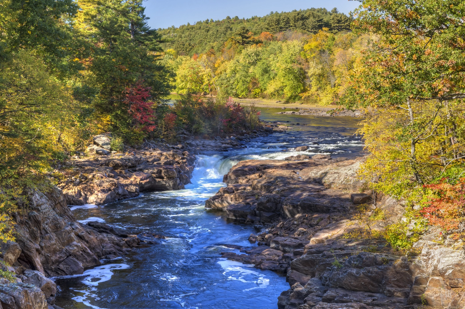
“A gentle stroll through mossy riverside shade leads to Rockwell Falls’ cool spray—watch for slick rocks.”
Rockwell Falls is best treated as a short, easy waterfall visit rather than a “mileage” hike—expect a brief walk from parking to viewpoints with essentially no meaningful elevation change (about 0 km / 0 mi recorded on some listings, and roughly 0 m / 0 ft gain). It’s ideal if you want a low-effort nature stop where the main objective is the falls themselves, plus a bit of riverside forest.
Getting to the start (car + public transport)
Because your “Hike head” and any coordinates weren’t provided, I can’t reliably convert a lon/lat to a nearest address or landmark yet. If you share a pin (or even the state/park name), I’ll translate it to the closest well-known trailhead/parking area and tailor directions precisely.
For now, plan like this: - By car: Search for the most relevant “Rockwell Falls” in your mapping app and confirm it matches the surrounding park/river name shown on the listing. Aim to arrive early on weekends—waterfall pull-offs and small lots fill quickly. - By public transport: Many waterfall trailheads are not directly served by transit. The most common workable approach is bus/train to the nearest town, then a rideshare/taxi to the trailhead/parking. If you tell me the nearest city you’ll be coming from, I’ll outline the most realistic transit chain.
What the walk is like
Most Rockwell Falls access routes are short: you’ll typically have a flat approach on packed dirt, gravel, or a short paved/boardwalk segment, then a few minutes of uneven footing near the water. Even when the “distance” is effectively negligible, the last 50–200 m (0.05–0.2 km / 0.03–0.12 mi) around a waterfall is often where people slip—expect: - Wet rock and algae-slick edges near spray zones - Roots and small steps where the path narrows - Short spur paths to different viewing angles (some unofficial)
If you’re navigating, load the route in HiiKER before you arrive; short waterfall walks can have multiple social trails that look “right” but lead to dead ends or unsafe river edges.
Landmarks, scenery, and what to look for
The main landmark is the waterfall drop and plunge pool (or cascades, depending on the site). Even on a very short outing, you’ll usually get: - Riverside forest with mossy boulders, ferns, and shade-loving plants - Spray-zone microclimate right at the falls—cooler air, slick surfaces, and louder ambient sound - Photogenic features like layered rock, small side cascades, and calmer pools just upstream or downstream
If there’s a maintained viewpoint, use it—many falls have deceptively undercut edges or crumbly banks that fail without warning.
Wildlife and seasonal conditions
Wildlife varies by region, but waterfall corridors commonly attract: - Songbirds and woodpeckers in riparian trees - Amphibians (frogs/salamanders) in damp leaf litter - Insects: expect mosquitoes/black flies in warm months, especially in still air near pools
Seasonality matters more than distance here: - After rain / spring melt: stronger flow, more spray, higher slip risk, and sometimes muddy access - Late summer: lower flow can expose more rock (nice for viewing), but can tempt people onto unsafe ledges - Winter (where applicable): ice forms in shaded sections; traction becomes the main “difficulty” factor
Safety and preparation (even for an “easy” stop)
Even with minimal distance and elevation, bring the basics: - Footwear with grip (trail runners or light hikers); avoid smooth-soled casual shoes - A light layer—spray zones can feel chilly - Water and a snack if you expect crowds or delays - Keep children close near water; currents below falls can be stronger than they look
If the area has posted barriers, treat them as hard limits—waterfall rescues are common precisely because “easy” destinations encourage people to push too close.
Historical significance (how to interpret it on-site)
Without the exact Rockwell Falls location, I can’t responsibly name specific historical events or Indigenous nations tied to that exact site. Once you provide the state/park or coordinates, I can add accurate local context (settlement history, land use like logging/mining, and any protected-area designation). In many waterfall regions, you’ll often see traces of: - Old logging grades or rail beds repurposed as footpaths - Stonework from early park infrastructure (steps, retaining walls, overlook foundations) - Place-name history tied to early landowners, mills, or local geology
If you share either (1) a lon/lat pin, or (2) the nearest town/park name, I’ll convert it to the nearest recognized address/landmark and rewrite this with precise access points, realistic walking distance to viewpoints, and the correct local natural/history details.

Surfaces
Asphalt
Unknown
Concrete
Comments and Reviews
User comments, reviews and discussions about the Rockwell Falls, New York.
average rating out of 5
0 rating(s)