Download
Preview
Add to list
More
884 m
~11 min
12 m
Loop
“Wander shaded Whitman woods to Long Island’s quiet high point—brief, gentle, and thoughtfully tread.”
This is a short, low-stress walk to the highest natural point on Long Island, with a gentle forested approach and a quick payoff at the summit marker. Expect a mostly shaded route on well-used park paths with minimal elevation change overall (about 1 km / 0.6 mi round trip, with ~0 m / 0 ft of sustained climbing—any ups and downs are brief and subtle).
Getting to the trailhead (car + public transport)
By car:
Aim for the main access into West Hills County Park (Town of Huntington) in West Hills, NY 11743. The most practical “nearest known” navigation target is the West Hills County Park parking areas off Sweet Hollow Road / Reservoir Road, which are the common jumping-off points for the Walt Whitman Trail network. Once parked, look for posted trail kiosks and blazes leading toward the Walt Whitman Trail.
By public transport:
The closest major rail access is the LIRR (Long Island Rail Road) to Huntington Station (Huntington, NY). From there, you’ll typically need a rideshare/taxi to reach West Hills County Park (there isn’t a simple, frequent bus-to-trailhead option that drops you right at the interior trail network). If you do use local buses, plan on a longer walk on roads/park edges and confirm the day’s schedules before committing.
What the hike is like (surface, grade, and pacing)
From the park access point, you’ll be on packed dirt and leaf-littered trail, sometimes with small roots and short sandy patches typical of Long Island’s glacial soils. Because the route is short, it’s easy to underestimate how “trail-like” it can feel after rain: expect a few soft spots and occasional puddling in low areas.
- Distance: ~1 km / 0.6 mi total
- Time: often 20–45 minutes, depending on stops
- Elevation: effectively flat overall; any rise to the summit is modest and gradual
Even though the difficulty is Easy, wear shoes with decent tread—roots and damp leaves can be slick, especially in fall.
Navigation and wayfinding (using HiiKER)
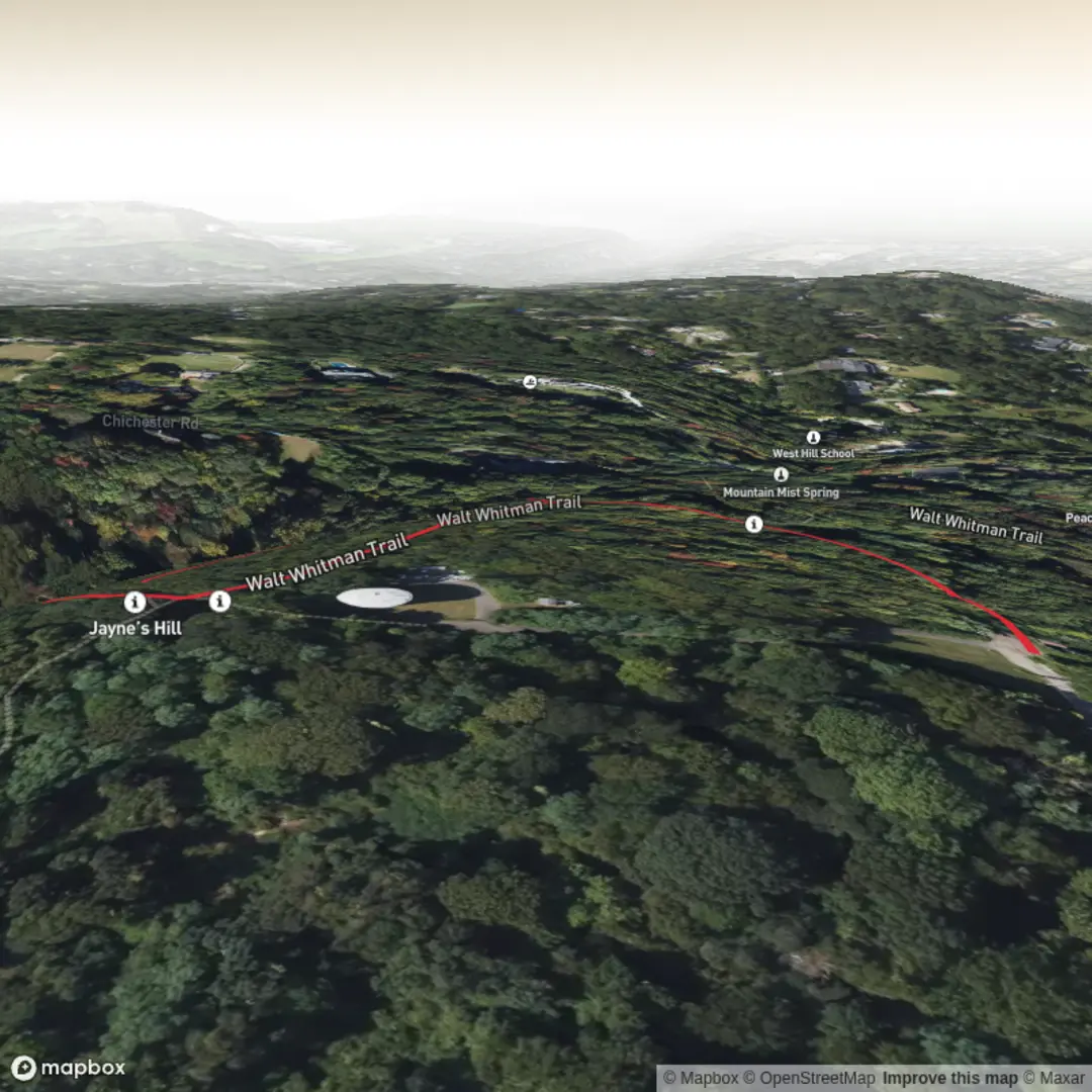
This area has multiple intersecting paths, and short hikes here can accidentally become longer loops if you follow the wrong junction. Use HiiKER to: - confirm you’re on the Walt Whitman Trail segment that trends toward Jayne’s Hill, - identify the spur/connector that leads to the summit area, - keep an eye on nearby parallel paths that can look similar in the woods.
Trail blazes and park signage are common, but junction density is the main reason people drift off-route.
Landmarks and the summit
The highlight is Jayne’s Hill, recognized as the highest point on Long Island (often cited around 400+ ft above sea level, though your hike’s gain is still minimal because you’re starting close to the high ground within the park). At the top, look for: - a summit marker/identifier (often a post or sign), - a small clearing feel rather than a dramatic overlook—this is a wooded high point, not a cliff-edge viewpoint.
Because the summit is forested, views are limited, but the “high point” novelty is the draw, and it’s a fun destination for families and peak-baggers.
Nature, terrain, and wildlife to watch for
West Hills County Park sits in classic Long Island woodland shaped by glacial history—rolling, sandy soils and mixed hardwood forest.
Common plants and habitat cues - Oak-dominated woods (especially oaks) with seasonal leaf cover - Understory shrubs and vines that can narrow the trail in summer - After wet periods, mushrooms and fungi are common along downed wood
Wildlife - White-tailed deer are frequent; ticks can be present anywhere deer travel. - Songbirds and woodpeckers are common in the canopy. - Small mammals (squirrels, chipmunks) are active near acorn-rich areas.
What to look out for - Ticks: Use repellent, consider light-colored clothing, and do a tick check after the hike—this is one of the most important practical considerations on Long Island trails. - Poison ivy: Often edges trails; “leaves of three” along sunny margins. - Mosquitoes/gnats: Can be noticeable in warm months, especially after rain.
Historical significance (Walt Whitman connection)
The Walt Whitman Trail name reflects the area’s association with Walt Whitman, the famed American poet who had strong Long Island roots. The park and surrounding West Hills area are closely tied to Whitman’s early life and the landscapes that influenced his writing. Hiking here isn’t just a quick nature walk—it’s also a small step through a region that helped shape one of the most influential voices in American literature.
Practical prep for a 1 km / 0.6 mi easy hike
- Water: A small bottle is enough, but bring more on hot, humid days.
- Footwear: Trail runners or light hikers; avoid smooth-soled shoes if it’s wet.
- Bug/tick protection: Strongly recommended in spring through fall.
- Weather: After rain, expect damp leaves and occasional mud; in winter, short icy patches can form in shaded spots.
If you share the start point coordinates (lon/lat) or a pin, I can translate them to the nearest trailhead/parking area name within West Hills County Park and describe the exact junctions you’ll take from that spot.

Surfaces
Unknown
Ground
Comments and Reviews
User comments, reviews and discussions about the Jayne's Hill via Walt Whitman Trail and Long Island Summit, New York.
average rating out of 5
0 rating(s)