Download
3D Flyover
Add to list
More
3.0 km
~43 min
76 m
Out and Back
“Stone steps and creekside paths thread a shale-and-sandstone gorge, where waterfalls keep surprising.”
A compact gorge-and-waterfalls walk with constant scenery changes, this route packs a lot into roughly 3 km / 1.9 mi with about 100 m / 330 ft of total climbing. Expect stone stairways, creekside footpaths, and frequent stops for overlooks of cascades and the narrow shale-and-sandstone gorge that makes this park famous.
Where the hike starts (and what’s nearby) The most practical starting point is the main day-use area in Stony Brook State Park, near the park’s central facilities and gorge access. The nearest widely recognized landmark/address to aim for is:
- Stony Brook State Park, 10820 NY-36, Dansville, NY 14437 (park entrance/primary access along NY-36)
From there, you’ll typically pick up the gorge trail system near the day-use/picnic area and follow signed paths toward the falls viewpoints.
Getting to the trailhead - By car: Drive to Stony Brook State Park (NY-36) and follow signs for the main parking/day-use area. Arrive earlier on warm weekends—parking fills quickly when the swimming/picnic areas are busy. - By public transport: The park is rural, so public transit is limited. The closest practical approach is usually to get to Dansville, NY (regional bus options vary by season/operator), then use a taxi/rideshare for the final leg to 10820 NY-36. If you’re planning a transit-only day, check schedules carefully and build in extra time—return options can be sparse.
What the trail is like You’ll be on a mix of packed dirt, gravel, rock steps, and short boardwalk/bridge sections. The “medium” feel comes less from distance and more from: - Stair climbs out of the gorge (short but punchy) - Wet, slick rock near spray zones - Narrow tread with drop-offs in places (usually fenced/railed at the most exposed overlooks)
Plan on 60–90 minutes moving time for 3 km / 1.9 mi, but many hikers take longer because the overlooks are hard to pass up.
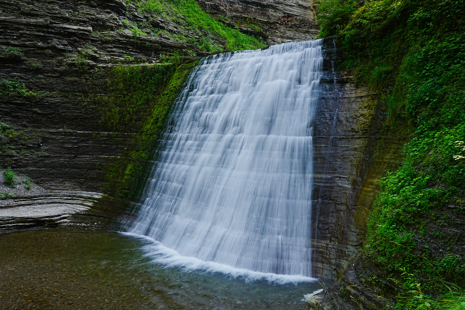
Waterfalls, gorge walls, and the best viewpoints
Within the first 0.5–1.0 km / 0.3–0.6 mi, you’ll start encountering the park’s signature scenery: a tight gorge carved by Stony Brook, with layered rock walls and multiple cascades. The falls here tend to appear in quick succession—short drops, angled slides, and stepped cascades—so keep your camera accessible but your footing even more so.
As you progress, the trail alternates between: - Creek-level walking beside rushing water (cooler, damper air; more slippery surfaces) - Overlook spurs and bridges that give you a top-down view into plunge pools and chutes
The cumulative climbing (about 100 m / 330 ft) is usually spread across several short ascents rather than one long hill. You’ll feel it most on the stair segments leaving the gorge floor to reach higher overlooks.
Navigation Trails in the gorge area are generally well-signed, but intersections can come quickly. Use HiiKER to confirm which side of the gorge you’re on and to avoid accidentally extending the hike by taking a longer loop connector.
Landmarks and natural features to watch for - Plunge pools and potholes: Look for circular scours in the rock where swirling stones have drilled into the bedrock over time. - Layered gorge walls: The rock strata are often visibly banded; after rain, seep lines and tiny springs can appear along the layers. - Footbridges: These are natural pause points—great for looking upstream at cascades framed by the gorge.
Nature and wildlife This is classic Finger Lakes / western New York gorge habitat: cool, moist microclimates near the water and drier upland edges above. - Plants: Expect ferns, mosses, and moisture-loving wildflowers near the creek; mixed hardwoods (maple, oak, beech) higher up. In spring and early summer, the gorge can be especially lush. - Birds: Songbirds in the canopy; you may also spot birds that favor moving water corridors. - Amphibians: Salamanders and frogs are most likely in damp areas—watch where you step, especially near shaded rock and leaf litter. - Mammals: Deer are common in the region; smaller mammals are more active at dawn/dusk.
Seasonal and safety notes (what to look out for) - Slippery stone: The biggest hazard is slick rock from spray, algae, or wet leaves. Trekking poles help on steps, but keep tips controlled on stone. - High water after storms: After heavy rain, the creek can run fast and loud, and splash zones expand. Expect more mud and reduced traction. - Winter/shoulder season: Ice can form on shaded steps and along the gorge floor. If you go in cold months, traction devices are often the difference between “fine” and “sketchy.” - Crowds: On peak days, the narrowest sections can bottleneck. Be patient at overlooks and pass only where the tread is wide and safe.
Historical significance of the area Stony Brook State Park sits within a region shaped by glacial history—the broader landscape of western New York was heavily influenced by the last Ice Age, with meltwater and post-glacial streams helping carve and deepen ravines like this one. The park itself is part of New York’s long tradition of protecting scenic gorges and waterfalls for public

Surfaces
Unknown
Gravel
Asphalt
Comments and Reviews
User comments, reviews and discussions about the Stony Brook State Park Falls, New York.
average rating out of 5
0 rating(s)