Download
3D Flyover
Add to list
More
3.1 km
~54 min
171 m
Out and Back
“Three waterfalls, mossy mist, and earned climbs—go steady on slick spray-zone steps.”
This short, punchy waterfall walk packs three distinct cascades into roughly 3 km / 1.9 mi with about 200 m / 656 ft of climbing—enough elevation to feel “earned,” but still very manageable if you pace the steeper bits and expect some slick footing near the water.
Getting to the trailhead (car + public transport)
Because the start point is only listed as “near,” the most reliable way to pinpoint the correct trailhead is to open the route in HiiKER and use the “Navigate to start” function—then match it to the nearest signed parking area or transit stop shown on the map. If you share the GPS coordinates (lon/lat) or a HiiKER link, I can convert that to the nearest known address or landmark and tailor the directions precisely.
In general, waterfall trailheads like this are usually accessed one of two ways:
- By car: Look for a signed falls parking area / day-use lot close to the lowest waterfall (often the most accessible one). Arrive early on weekends—small lots fill quickly, and roadside parking is often restricted near popular falls.
- By public transport: If the area is served by buses, the closest stop is typically on the nearest main road, followed by a 0.5–2.0 km (0.3–1.2 mi) walk on shoulders or connector paths to the trailhead. Plan for limited service frequency and earlier last departures than you’d expect.
What the hike feels like underfoot
Expect a mix of packed dirt, gravel, and short rocky/rooty sections, with the most careful footing required: - Within spray zones near the falls (slick rock, wet boardwalks, muddy edges) - On short, steep connectors between viewpoints (erosion ruts, loose gravel) - Along any streamside traverses (undercut banks, slippery roots)
Even though the distance is modest, the 200 m / 656 ft gain often comes in bursts, so it can feel more strenuous than the number suggests—especially if you stop often for photos and then restart on a climb.
Route flow and landmarks (approximate distances)
0.0–0.8 km (0.0–0.5 mi) | +40 m / +130 ft (gentle warm-up)
The opening usually follows a well-used path toward the first major viewpoint. You’ll likely hear water before you see it. Watch for spur paths—some lead to great photo angles, others to unstable edges. Stay on established tread where possible to avoid trampling fragile streamside plants.
0.8–1.4 km (0.5–0.9 mi) | +80 m / +260 ft (steeper connector)
This is commonly where the “medium” rating shows up: a climb away from the first falls toward the central cascade. Expect steps, rock slabs, or a steeper dirt grade. In wet weather, this section can be the crux—take smaller steps and use trekking poles if you have them.
1.4–2.2 km (0.9–1.4 mi) | +60 m / +200 ft (rolling, viewpoint hopping)
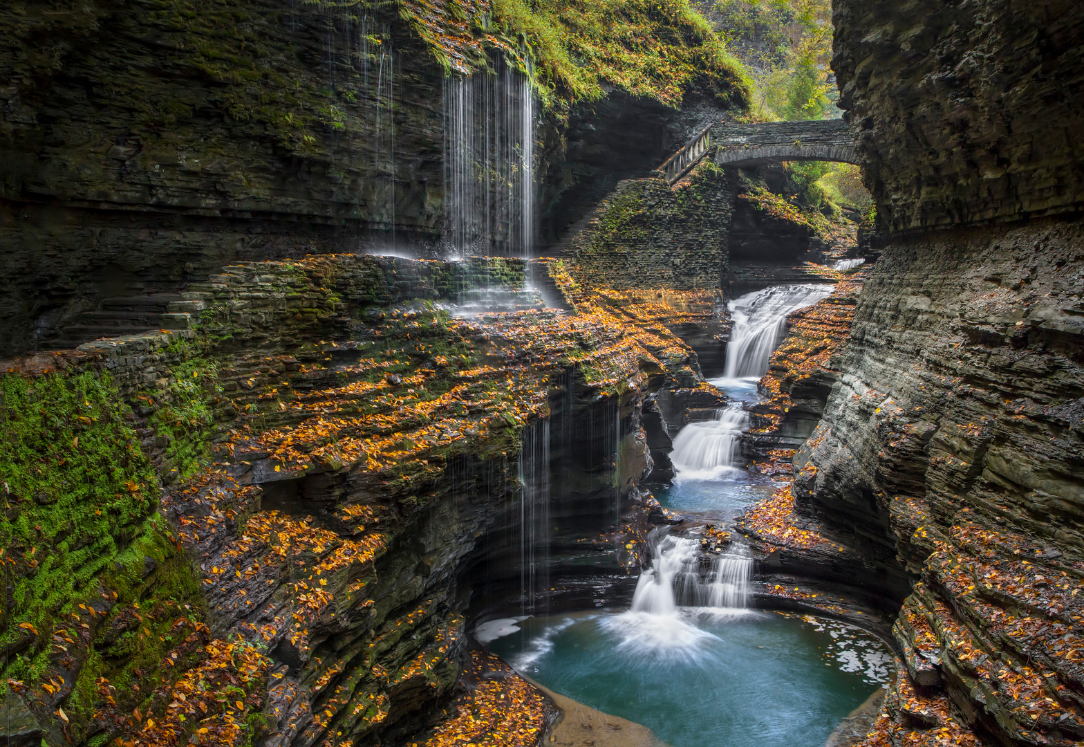
You’ll move between overlooks of the Central Cascade—often the most dramatic “power” section of the drainage. Look for calmer pools above the drop and faster, aerated water below. If there are bridges, they’re usually the safest way to cross; avoid rock-hopping unless conditions are clearly low and stable.
2.2–3.0 km (1.4–1.9 mi) | +20 m / +65 ft (final approach + return/loop finish)
The approach to Rainbow Falls often involves a slightly more enclosed, mossy corridor where mist and filtered light can create the “rainbow” effect when the sun angle is right. If you’re there midday with sun behind you and spray in front, you have the best odds. Expect crowds at the prime viewpoint—be patient and keep moving so others can share the space.
Nature, wildlife, and what to look for
Waterfall corridors tend to concentrate life. Depending on the region and season, keep an eye out for:
- Mosses, liverworts, and ferns thriving in constant humidity near the spray zone
- Songbirds using the dense riparian cover (you’ll often hear them more than see them)
- Amphibians (especially in spring): salamanders/newts near seeps and shaded stream edges—watch where you place hands and feet on wet rocks
- Insects: mosquitoes and black flies can be intense near water in warm months; bring repellent or wear long sleeves
If the trail passes through mixed forest, you may also see woodpecker sign (fresh chips at the base of snags) and animal tracks in soft mud near the creek.
Safety and “medium” difficulty realities
- Slippery surfaces: The most common hazard is a simple slip near viewpoints. Wet rock can be as slick as ice—especially where algae grows.
- Edge exposure: Many waterfall viewpoints sit above steep drops. Keep a buffer from the lip, especially if the ground is undercut or muddy.
- High water: After heavy rain or snowmelt, spray increases, footing worsens, and informal crossings become unsafe. If water is roaring and brown, treat all stream edges as unstable.
- Crowds: Popular falls routes can feel congested. Expect sudden stops, people stepping sideways for photos, and kids/dogs near edges—slow down in tight sections.
Navigation and planning with Hii

Surfaces
Unknown
Asphalt
Concrete
Comments and Reviews
User comments, reviews and discussions about the Minnehaha Falls, Central Cascade and Rainbow Falls, New York.
average rating out of 5
0 rating(s)