
Download
3D Flyover
Add to list
More
808 m
~10 min
13 m
Out and Back
“A breezy canal-side wander to a misty waterfall viewpoint—easygoing, but watch slick edges.”
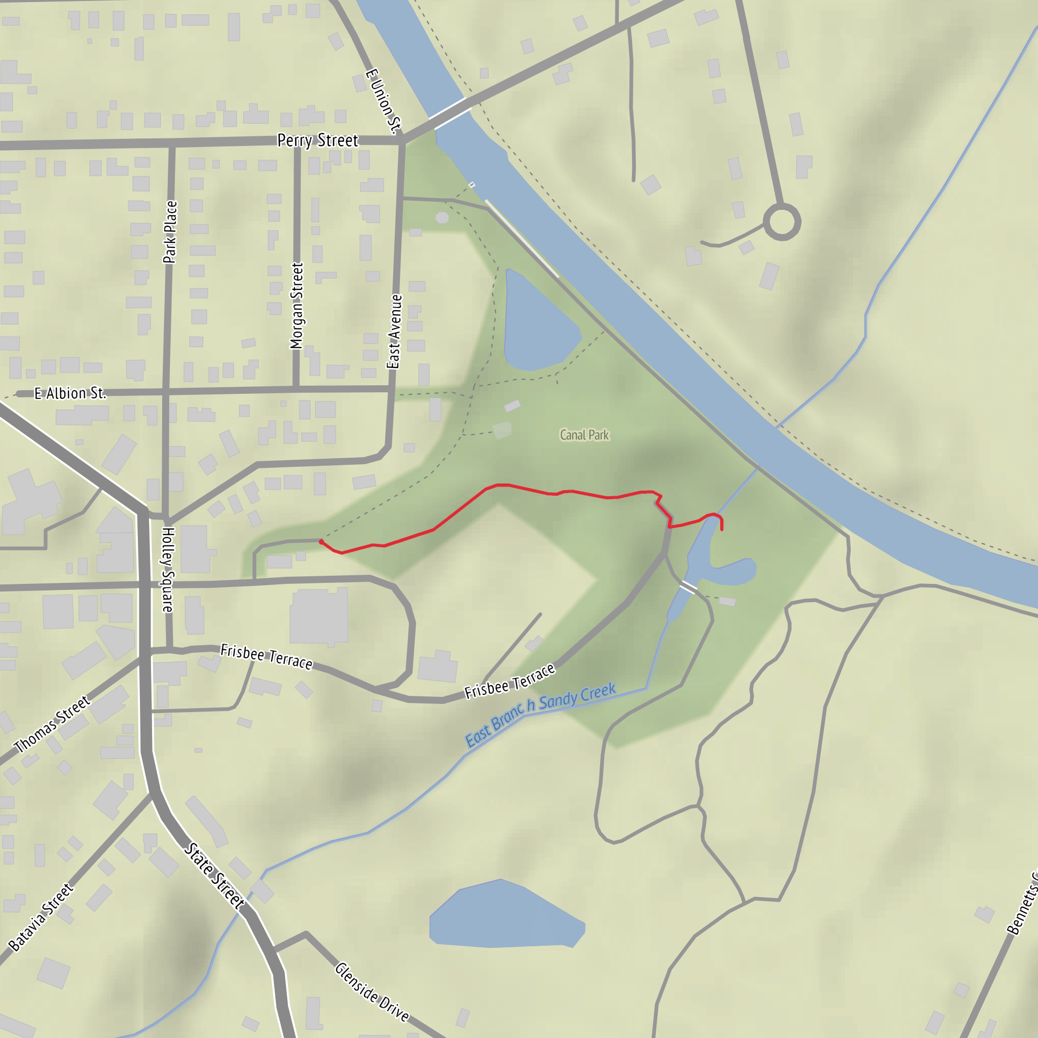
This is a short, mostly level out-and-back stroll (about 1 km / 0.6 mi total with roughly 0 m / 0 ft of climbing) that suits families, casual walkers, and anyone wanting a quick waterfall viewpoint without committing to a longer day. Expect paved paths or well-compacted park trails, frequent foot traffic in good weather, and a route that’s more about scenery and a single highlight than endurance.
Getting to the trailhead (Canal Park area)
Because the start point is only listed as “near” and no coordinates were provided, the most reliable way to pinpoint the exact trailhead is to open HiiKER and search “Honey Canal Falls via Canal Park”—then use the mapped start marker to confirm the nearest street address/landmark.
By car - Aim for Canal Park parking areas (typically signed from the nearest main road). In many towns, “Canal Park” lots fill quickly on weekends; arriving early helps. - If there are multiple Canal Park entrances, choose the one closest to the canal-side promenade/trail (HiiKER’s start marker will show which entrance aligns with the route).
By public transport - Look for the nearest bus or rail stop that serves the Canal Park district/park entrance. From there, it’s usually a short walk on sidewalks to the park paths. - If you share your city/state (or the trail’s coordinates), I can translate that into the nearest known address or landmark and suggest the most practical transit stop.
Once you’re at Canal Park, the route is straightforward: you’ll be following the canal corridor toward the sound and sight of the falls.
What the walk is like
From the park entrance, you’ll typically start on a maintained path—often paved or fine gravel—running alongside the canal. Over the first 0.3–0.5 km (0.2–0.3 mi), you’ll pass classic canal-side features: straightened water edges, small footbridges, and occasional benches or viewing pull-offs. The terrain stays essentially flat, so the “effort” is more about footing and awareness around water than physical exertion.
As you near the falls (usually around 0.5 km / 0.3 mi from the start on a 1 km total walk), you’ll notice: - A rise in ambient noise from moving water - Cooler air and heavier mist in humid conditions - Darker, slicker surfaces on rocks, boardwalks, or concrete edges
The turnaround is commonly at a designated viewpoint, railing, or natural pinch point where the canal constricts and drops. Plan a few extra minutes here—this is the main payoff of the walk.
Landmarks, nature, and what to look for
Even on a short route, canal corridors can be surprisingly rich:
Water and canal infrastructure - Watch for remnants of canal engineering: stonework, retaining walls, old lock-like structures, or straightened banks. These features often hint at the area’s working-waterway past—canals were historically built to move timber, grain, coal, or manufactured goods before modern road networks dominated. - The falls themselves may be natural, partially engineered, or enhanced by channeling—look for uniform stone blocks or unusually straight edges that suggest human shaping.
Plants - Expect moisture-loving vegetation near the waterline: reeds/sedges, mosses on shaded stone, and dense shrubs where the bank is less manicured. - In warmer months, canal edges can be thick with wildflowers and grasses; in cooler seasons, the open sightlines make the water features easier to photograph.
Wildlife - Common sightings along calm canal stretches include ducks, geese, and small songbirds. Near the falls, you may spot birds that hunt insects in the misty air. - If the canal connects to broader wetlands or a river system, keep an eye out for turtles or fish in clearer pools. - Give wildlife space—especially waterfowl with young—and keep snacks secured.
Safety and practical planning (easy hike, real hazards)
Even with an “Easy” rating, the main risks are water-adjacent:
- Slippery surfaces: Mist from the falls can make stone, concrete, and boardwalks slick. Shoes with decent tread are more important than hiking boots here.
- Edge awareness: Canal banks can drop abruptly. Keep children close near railings or unprotected edges.
- High water/ice: After heavy rain or during freeze-thaw periods, the safest viewpoint may be behind barriers. If any section is flooded or icy, turn around—there’s no need to force it on a 1 km walk.
- Crowds: On popular days, expect cyclists, runners, and strollers. Stay right, pass politely, and be cautious at blind corners.
Navigation (keep it simple)
This route is usually intuitive—follow the canal to the falls and return the same way—but it’s still worth downloading the track on HiiKER before you arrive. That helps you: - Confirm the correct Canal Park entrance - Identify the intended viewpoint/turnaround - Avoid accidentally continuing onto longer canal greenways if the park connects to a larger trail network
What to bring for a 1 km / 0.6 mi outing
- Water (a small bottle is enough for most people)
- Light rain layer if conditions are changeable (mist near falls can dampen you)
- Phone with HiiKER map downloaded
- If you’re photographing: a lens cloth (spray from the falls can spot lenses)
If you send the lon/lat for the start point (or a HiiKER link), I can convert it to the **nearest known address or significant landmark
Comments and Reviews
User comments, reviews and discussions about the Honey Canal Falls via Canal Park, New York.
average rating out of 5
0 rating(s)
