Download
3D Flyover
Add to list
More
242 m
~3 min
6 m
Out and Back
“A jewel-like waterfall stroll—mossy, mist-kissed, and best savoured with careful footing.”
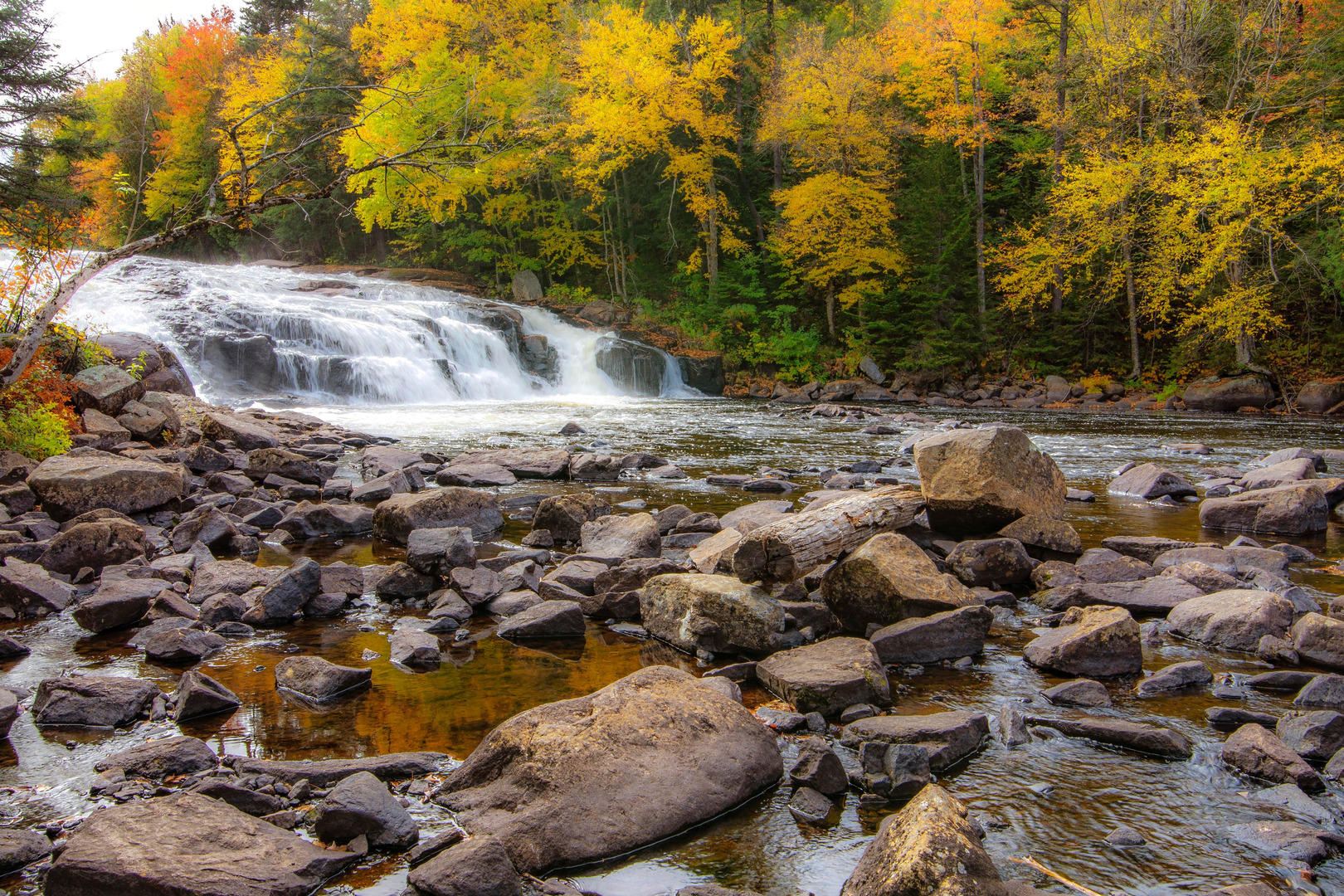
Buttermilk Falls is typically approached as a short, waterfall-focused outing rather than a long-distance hike—more of a “get to the base (or viewpoint), explore safely, and linger” walk. With your listed distance and elevation gain both near zero, plan for a compact route (often well under 0.6 mi / 1 km total) where the main effort comes from uneven footing, wet rock, steps, and crowding rather than sustained climbing. Even on a “short” route, the difficulty can feel Medium because waterfalls create slick surfaces, spray, and tricky edges.
Getting to the start (car + public transport)
Because “Buttermilk Falls” is a very common trail name (there are several across the U.S.), the exact directions depend on which one you mean. If you share a lon/lat, a state, or the nearest town/park, I can convert that to the nearest known address/landmark and give precise routing.
In the meantime, here’s how these trailheads are usually accessed:
- By car: Most Buttermilk Falls trailheads are reached via a small roadside pull-off, a state park lot, or a day-use parking area near a creek. Arrive early on weekends—waterfall spots fill fast, and overflow parking often means walking along narrow shoulders.
- By public transport: Many waterfall trailheads are not directly served by transit. The most workable approach is usually:
- Take regional rail/bus to the nearest town center, then
- Use a local taxi/rideshare to the trailhead (often a 10–30 minute ride).
If you tell me the specific Buttermilk Falls location, I’ll map the most realistic transit chain and the closest drop-off point.
What to load into HiiKER: search the exact trail listing for “Buttermilk Falls” in your state/region, confirm the trailhead pin matches the parking area you intend to use, and download the route for offline use—waterfall ravines often have patchy reception.
What the hike feels like (even when it’s “0 km”)
Expect a short approach on one or more of the following: - Packed dirt and gravel path that can turn muddy after rain - Boardwalk/steps near viewpoints - Rocky creekside tread with roots and slick stone - Short spur paths to different overlooks
Even if the net elevation gain is close to 0 ft / 0 m, you may still do small ups/downs—think 10–60 ft / 3–18 m in little bursts—especially if there are stairs to a viewing platform or a side path to the base of the falls.
Waterfall hazards and what to watch for
Waterfall areas concentrate risk into a small space. The most important things to plan around:
- Slippery rock and algae: Dark, wet stone near the spray zone can be as slick as ice. Treat all wet rock as “no traction,” even with good boots.
- Undercut edges: The lip and sides of falls can be undercut by erosion. Stay behind railings and well back from the brink even if it looks solid.
- Flashy water levels: After storms, snowmelt, or heavy upstream rain, the creek can rise quickly. A calm-looking approach can become hazardous within minutes.
- Crowds and distraction: People step backward for photos. Give edges extra space and pass carefully.
- Cold-water risk: If someone slips in, cold shock can happen fast even in mild air temperatures.
Footwear: prioritize grippy soles over light sneakers. Trekking poles can help on wet steps, but keep hands free near railings and crowded overlooks.
Landmarks, scenery, and the natural setting
Most Buttermilk Falls hikes are built around a single dramatic cascade (sometimes a tiered set of drops) with a short approach to: - a base pool viewpoint (often the most popular photo spot), - a mid-falls overlook (if there are steps/railings), and/or - a top-of-falls viewpoint (only where a maintained trail exists—never scramble to the top on unofficial paths).
Ecologically, waterfall ravines tend to be cooler and wetter than surrounding forest. Look for: - Mosses, ferns, and moisture-loving wildflowers along shaded rock walls - Hemlock/hardwood mixes in the canopy in many eastern sites, or conifers and riparian shrubs in western sites - Songbirds using the ravine as a travel corridor - Amphibians (salamanders, frogs) in damp leaf litter—watch your step and avoid handling them
Wildlife notes (general): black bears are possible in many regions but rarely an issue on short, busy waterfall trails; the more common concerns are ticks (brushy edges), stinging insects in warm months, and snakes sunning on rocks in shoulder seasons. Do a tick check after, especially if you step off the main tread.
Historical significance (what’s commonly true of waterfall sites)
Without the exact state/park, the safest way to frame history is what’s typical of Buttermilk Falls areas across the U.S.:
- Indigenous homelands: Waterfalls and river corridors were often important travel routes and seasonal gathering areas long before modern trails. Many parks now acknowledge the original stewards of the land—check the local site signage once you identify the specific location.
- Milling and early industry: “Falls” frequently powered gristmills, sawmills, or small industrial works in the 18th–

Comments and Reviews
User comments, reviews and discussions about the Buttermilk Falls, New York.
average rating out of 5
0 rating(s)