Download
3D Flyover
Add to list
More
9.8 km
~2 hrs 48 min
508 m
Loop
“A punchy Devil’s Path romp—steep scrambles through shadowy forest to wind-brushed ledges and wide Catskill views.”
This is a rugged Catskills out-and-back/partial-loop style hike on the eastern end of the Devil’s Path in the Indian Head Wilderness (Catskill Park), packing a lot of steep, rocky trail into a relatively short distance. For a “~10 km / ~6.2 mi, ~500 m / ~1,640 ft” day, expect sustained climbing, a few scrambly moves, and big ledge views—especially from the Jimmy Dolan Notch Overlook area and the open rock on/near Indian Head’s high points. The Devil’s Path is widely regarded as one of the Catskills’ most demanding trails for its constant steep ups/downs and rough footing. (dec.ny.gov)
Getting to the start (car + public transport options)
Trailhead / parking (car):
Most hikers start from the Prediger Road Parking Area (DEC) at the end of Prediger Road, reached via the Platte Clove area (near Tannersville/Hunter on the east side of the Catskills). This is the recognized eastern trailhead for the Devil’s Path. (dec.ny.gov)
- Arrive early on weekends/peak foliage—parking is limited and this area is popular.
Public transport:
There’s no truly “door-to-trailhead” public transit to Prediger Road. The most workable approach is:
- Take intercity transit to the Hudson Valley/Catskills gateway towns (often Kingston, Saugerties, or the Hunter/Tannersville area depending on seasonal service), then use a taxi/rideshare to Prediger Road. Service can be spotty—plan a backup and don’t count on cell coverage at the trailhead.
- If you’re coordinating with a group, a car shuttle is far more reliable than trying to time a pickup at the end of Prediger Road.
What the route feels like underfoot (and why “Medium” can feel harder)
Even though the stats are moderate on paper (~10 km / 6.2 mi; ~500 m / 1,640 ft), the Devil’s Path character makes this hike feel more strenuous than many longer trails: - Footing: rock steps, roots, and uneven ledge slabs that slow your pace. - Grade: short, steep pitches rather than a steady climb. - Hands-on moments: you may use hands for balance on steeper rock/ledge sections, especially if wet.
Use HiiKER to keep a close eye on junctions—this area has multiple intersecting trails (Devil’s Path, Jimmy Dolan Notch Trail, Overlook connections), and it’s easy to follow the wrong line when you’re tired or visibility drops.
On-trail breakdown (approximate distances + elevation)
Distances vary depending on the exact turnaround point (overlook vs. summit vs. notch), but this matches the common “Indian Head + Jimmy Dolan Notch Overlook” outing.
0.0 km / 0.0 mi — Prediger Road trailhead (start)
You’ll begin in mixed Catskill forest—hardwoods lower down, with more conifers as you gain elevation. The trail quickly establishes its tone: narrow tread, frequent roots, and early steepening.
~0.4 km / ~0.25 mi — Junction opportunities (watch your blazes)
Many versions of this hike use the Jimmy Dolan Notch Trail as part of the route (either to reach the notch between Indian Head and Twin, or to connect toward viewpoints). Pay attention here—confirm your intended line on HiiKER before committing, especially if you’re trying to hit the overlook first.
~2.5–3.5 km / ~1.6–2.2 mi — Steeper climbing into the notch/overlook zone
This is where you’ll feel most of the day’s elevation gain. Expect:
- Short rock scrambles and steep dirt chutes
- Slippery conditions after rain (roots + angled rock)
- Limited water on the ridge/trail—carry what you need
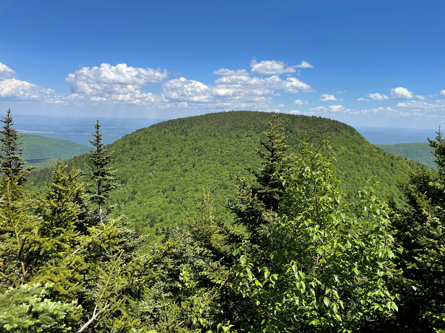
~4–5 km / ~2.5–3.1 mi — Jimmy Dolan Notch Overlook (primary viewpoint area)
The “overlook” is the reward for the grind: open ledges and big Catskill escarpment scenery on clear days. Wind exposure can be noticeable even when the woods below are calm—bring a layer.
**Optional extension — Indian Head high points /

Surfaces
Unknown
Ground
Dirt
Unpaved
Comments and Reviews
User comments, reviews and discussions about the Indian Head Mountain and Jimmy Dolan Notch Overlook via Devil's Path, New York.
average rating out of 5
0 rating(s)