Download
3D Flyover
Add to list
More
35.4 km
~2 days
2315 m
Multi-Day
Devil's Path, nestled in the heart of the Catskill Mountains near Greene County, New York, is a formidable trek that spans approximately 35 kilometers (about 22 miles) and ascends roughly 2300 meters (approximately 7500 feet) in elevation. This point-to-point trail is renowned for its challenging terrain and is often rated as Extra Difficult, making it a magnet for seasoned hikers seeking a demanding adventure.
Getting to the Trailhead
The western terminus of Devil's Path is located near the town of Phoenicia, NY. Those arriving by car can navigate to Prediger Road, which is the closest landmark to the trailhead. For those relying on public transportation, the nearest bus stops are in the towns of Phoenicia or Tannersville, from which you can arrange a taxi or a local shuttle service to reach the starting point.
Trail Overview
As you embark on Devil's Path, prepare for steep ascents and descents, technical rock scrambles, and narrow ledges that demand careful footing and a steady pace. The trail traverses several peaks, including Indian Head, Twin, Sugarloaf, Plateau, and West Kill Mountains, each offering its own unique challenges and vistas.
Notable Landmarks and Natural Features
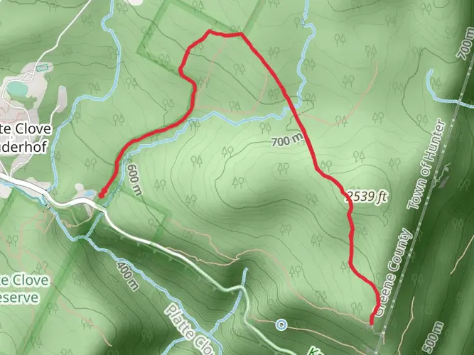
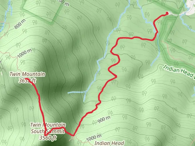
Indian Head Mountain: The first major peak on the trail, Indian Head offers stunning views and a taste of the rugged terrain to come. Expect a climb of about 1100 meters (3600 feet) over 5 kilometers (3 miles) to reach the summit.
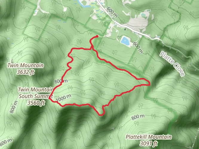
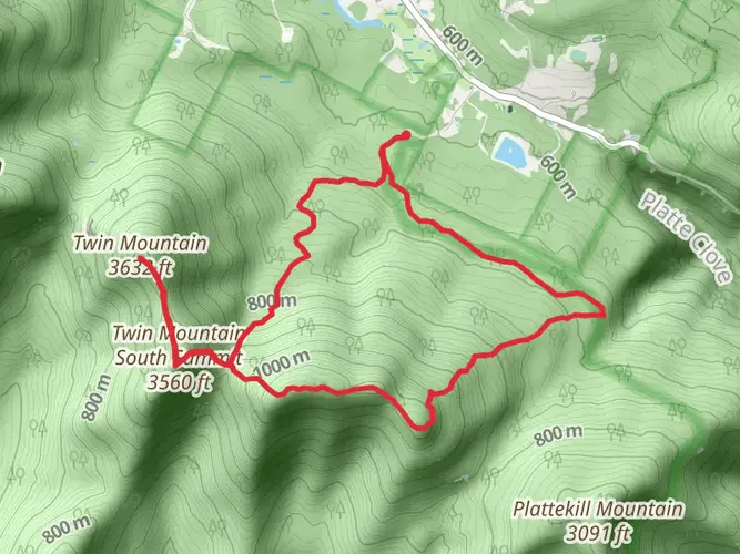
Twin Mountain: Following Indian Head, Twin Mountain presents two summits, with the second peak slightly higher. This section includes a steep descent into the col between the peaks and another ascent, totaling around 600 meters (2000 feet) of elevation gain.
Sugarloaf Mountain: Known for its challenging rock scrambles, Sugarloaf requires hikers to navigate through boulder-strewn paths. The ascent here adds another 500 meters (1640 feet) of elevation over a distance of 3 kilometers (2 miles).
Plateau Mountain: With a long, flat summit, Plateau Mountain offers a brief respite from the relentless climbs. However, the approach and descent are steep, contributing to the trail's overall elevation gain.
West Kill Mountain: The highest peak on Devil's Path at 1220 meters (4000 feet), West Kill Mountain is the final major climb. The summit, known as Buck Ridge Lookout, provides panoramic views of the Catskills.
Wildlife and Flora
The Catskill Mountains are home to a diverse range of wildlife, including black bears, deer, and a variety of bird species. Hikers should be aware of their surroundings and practice bear safety. The trail also winds through dense forests of hemlock, birch, and maple, with the foliage offering a spectacular display of colors in the fall.
Historical Significance
Devil's Path is steeped in lore, with its ominous name believed to be derived from early settlers' impressions of the treacherous terrain. The Catskills themselves have a rich history, having been a favored destination during the 19th-century American Romantic movement and inspiring artists and writers like Thomas Cole and Washington Irving.
Navigation and Preparation
Given the trail's difficulty, it is imperative to carry a detailed map and compass or use a reliable GPS tool like HiiKER to navigate the path. Hikers should be well-prepared with adequate water, food, and gear for sudden weather changes. It is also advisable to plan for a multi-day hike or arrange for pick-ups at various access points along the trail if attempting to complete it in a single day.
Safety and Etiquette
Due to the trail's rugged nature, it is essential to hike with a partner or group. Leave no trace principles should be strictly followed to preserve the natural beauty of the Catskills. Additionally, hikers should be prepared for remote and potentially hazardous conditions by carrying a first aid kit, headlamp, and emergency shelter.
Devil's Path is not just a hike; it's an endurance test that rewards the brave with breathtaking views, a sense of accomplishment, and a deep connection with the wild heart of the Catskill Mountains.

What to expect?
Activity types
Frequently asked questions
How long does it take to hike Devil's Path in the Catskills?
Devil's Path is 35.45 km, or about 22 miles, with 2,315 meters of climbing, so it is usually treated as a full-day sufferfest for very strong hikers or a 2-day backpacking trip for most parties. The route is point-to-point and crosses Indian Head, Twin, Sugarloaf, Plateau, and West Kill, with repeated steep ascents and descents that slow the pace well below normal trail mileage.
Where do you start and finish the Devil's Path hike?
Devil's Path runs point-to-point across the central Catskills from the Prediger Road Parking Area on the east end to County Route 6, also signed as Spruceton Road, on the west end. The trail crosses from the Indian Head Wilderness into the Hunter-West Kill Wilderness and finishes near the Devils Path Trailhead parking lot on Spruceton Road.
Which mountains are on Devil's Path?
The main summits on Devil's Path are Indian Head Mountain, Twin Mountain, Sugarloaf Mountain, Plateau Mountain, and West Kill Mountain. Those five peaks are the core of the route and account for the trail's reputation as one of the hardest hikes in New York because the climbs are steep, rocky, and closely stacked together.
Is Devil's Path really the hardest hike in the Catskills?
Devil's Path is widely regarded as one of the toughest hikes in the Catskills, and the numbers back that up: 35.45 km with 2,315 meters of elevation gain on rugged, technical terrain. The route is rated Extra Difficult and is known for steep scrambles, narrow ledges, and punishing descents between major peaks rather than one long steady climb.
Can you camp on Devil's Path?
Camping is possible along sections of Devil's Path on Catskill Forest Preserve land, but the rules matter. Backcountry camping is allowed at designated sites and generally below 3,500 feet if camp is at least 150 feet from water, roads, and trails; in the Catskills, camping above 3,500 feet is prohibited between March 22 and December 20 except in an emergency. Devil's Tombstone Campground also sits directly on the route in Stony Clove.
Where can you park for Devil's Path?
The standard east-end parking for Devil's Path is the Prediger Road Parking Area, and the west-end access is the Devils Path Trailhead parking lot on Spruceton Road, about 3.8 miles from Route 42. Parking restrictions apply on Route 23A and Platte Clove Road, so roadside parking outside designated lots can lead to ticketing or towing.
Is Devil's Path a loop or an out-and-back trail?
Devil's Path is not a loop. It is a point-to-point, multi-day trail that runs roughly 35.45 km across Greene County, so most hikers either arrange a shuttle between Prediger Road and Spruceton Road or turn it into a long out-and-back with much more distance and elevation.
Comments and Reviews
User comments, reviews and discussions about the Devil's Path, New York.
4.5
average rating out of 5
12 rating(s)