Download
3D Flyover
Add to list
More
4.2 km
~1 hrs 3 min
129 m
Loop
“A compact loop of shady creek coolness, snug gorge stone, and breezy rim views—watch footing.”
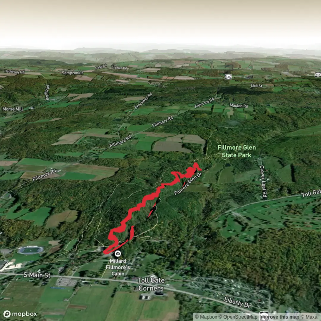
Dry Creek via the Gorge Trail and North Rim Trail is a compact loop-style outing (or lollipop, depending on the exact access point) that packs a lot into roughly 4 km / 2.5 mi with about 100 m / 330 ft of climbing. Expect a mix of shaded creekside walking, a short gorge section where the walls feel closer and cooler, and a more open rim segment with wider views and a breezier feel. With the distance being short but the terrain changing frequently, it tends to feel “Medium” more because of footing and short, punchy grades than because of endurance.
Getting to the trailhead (car + public transport)
You wrote “Hike head: near” but didn’t include the location coordinates or a place name. If you share a lon/lat (or even the park/trailhead name), I can convert it to the nearest known address or prominent landmark and give precise directions.
For now, here’s the practical approach that works for most Dry Creek/Gorge/North Rim trail systems: - By car: plan to park at the signed Gorge Trail / North Rim Trail trailhead lot (often a small paved or gravel pull-in). Arrive early on weekends—short scenic hikes fill up fast, and overflow parking can be limited or prohibited along narrow access roads. - By public transport: many canyon and rim trailheads are not directly served by buses/trains. The most reliable method is usually transit to the nearest town center, then a rideshare/taxi to the trailhead. If you tell me the nearest city (or provide coordinates), I’ll map the most realistic transit-to-rideshare handoff point.
What the hike feels like, step by step
0.0–0.8 km (0.0–0.5 mi): settling into the creek corridor
The opening is typically the gentlest part: a defined path that trends toward the drainage. You’ll often notice a temperature drop as you enter the creek’s influence—more shade, more humidity, and softer light. Footing here can be deceptively easy until you hit the first rocky patches: watch for rounded stones that roll underfoot and roots that cross the tread.
0.8–2.0 km (0.5–1.25 mi): the gorge section—cooler air, tighter walls, trickier footing
This is where the hike earns its “Medium” label. The trail commonly narrows and becomes more uneven, with short rises and dips as it threads along the gorge. Expect:
- Rock steps and ledges (natural or built) that can be slick if there’s seepage.
- Seasonal water: after rain or snowmelt, you may have shallow crossings or wet rock. Even when the creek is low, algae-darkened stone can be slippery.
- Fallen debris: narrow drainages collect branches and occasional downed trees; step carefully around them to avoid ankle twists.
If you’re using navigation, keep HiiKER handy here—gorge trails sometimes have faint side paths (social trails) that lead to viewpoints or down to the water and can pull you off-route.
2.0–3.2 km (1.25–2.0 mi): climbing to the North Rim—short, punchy gain
The climb to the rim is usually the main elevation gain of the day, totaling about 100 m / 330 ft across the whole hike. It rarely feels like a long ascent, but it can be steeper for short bursts, especially where the trail switchbacks or climbs directly up a rib. You’ll likely transition from riparian plants to drier, more sun-exposed vegetation. This is a good place to pace yourself: steady steps, avoid rushing on loose gravel.
3.2–4.0 km (2.0–2.5 mi): rim walking—views, wind, and exposure
On the North Rim segment, the trail often becomes more open with:
- Wider sightlines across the drainage and down into the gorge.
- More wind (a factor in cooler months and on hot days alike).
- Sun exposure: even a short rim stretch can feel intense midday.
Stay back from cliff edges—rim trails can have undercut sections or crumbly margins, and the safest line is usually a few feet inside the obvious edge.
Landmarks, nature, and wildlife to look for
Even without the exact region specified, gorge-and-rim hikes tend to share a few consistent highlights: - Riparian corridor features: cottonwoods/willows (where present), mossy rock, and shaded pockets that hold moisture longer than surrounding slopes. - Rock layers and erosion: gorges often reveal distinct strata—look for changes in color and texture that show different depositional periods and how water carved the channel over time. - Birdlife: canyon wrens and other songbirds often favor rocky drainages; raptors may ride thermals near the rim. - Mammals and reptiles: deer are common in many rim-and-creek systems; lizards and snakes may be active on warm rock. Give all wildlife space and watch where you place hands/feet when stepping up ledges.
Hazards and what to prepare for
- Slippery rock in the gorge: bring footwear with reliable traction; move deliberately on dark, polished, or wet stone.
- Flash-flood potential: if this is in an arid or monsoon-prone region, avoid narrow gorges when storms are forecast upstream—even if skies are clear at the trailhead.
- Heat and exposure on the rim: carry more water than the short distance suggests. For

Surfaces
Dirt
Unknown
Comments and Reviews
User comments, reviews and discussions about the Dry Creek via Gorge Trail and North Rim Trail, New York.
average rating out of 5
0 rating(s)