Download
3D Flyover
Add to list
More
5.6 km
~1 hrs 43 min
360 m
Loop
“A punchy, rock-hopping climb to Delaware Water Gap’s skyline views, then a gentler forest glide.”
This is a short, steep loop with a big payoff: a rapid climb to one of the best overlooks in the Delaware Water Gap, then a more gradual return through mixed forest with occasional rocky footing. Expect sustained grades, rock steps, and sections where you’ll be using hands for balance on boulders—especially on the way up.
Getting to the trailhead (car + public transport)
Nearest well-known start point: the main Mount Tammany trailhead at Dunnfield Creek Natural Area / Mount Tammany Trailhead, on the New Jersey side of the Delaware Water Gap, just off I‑80 at Exit 1. The parking area is commonly signed for “Dunnfield Creek / Mt. Tammany” and sits along Old Mine Road / NPS roads near the Delaware Water Gap National Recreation Area facilities.
- By car: From I‑80, take Exit 1 and follow signs toward the Delaware Water Gap / Old Mine Road area. Arrive early on weekends—this is a very popular hike and parking can fill quickly.
- By public transport: The Delaware Water Gap area has limited direct transit to the trailhead. The most workable approach is typically:
- Bus/train to Stroudsburg/East Stroudsburg, PA (regional hub), then
- Rideshare/taxi to the Dunnfield Creek / Mount Tammany trailhead (a short drive). If you’re trying to do this fully car-free, check current regional bus schedules to Stroudsburg and plan for a rideshare backup—service can be spotty.
What the route feels like (distance + elevation)
- Total distance: ~6 km / 3.7 mi
- Total elevation gain: ~400 m / 1,300 ft
- Type: commonly done as a loop using the Mount Tammany Trail for the ascent and the Pahaquarry Trail for the return (with short connectors depending on the exact loop variant).
Even though the mileage is modest, the climb is concentrated—most of the elevation comes quickly, which is why it earns a “Difficult” feel for many hikers.
The climb: Mount Tammany Trail (steep, rocky, relentless)
From the trailhead, the path wastes no time gaining height. You’ll move through hardwood forest (oak, maple, hickory) and quickly encounter rock steps and boulder-strewn tread. The grade is sustained and often steep enough that pacing matters more than speed.
Underfoot, expect: - Angular rocks and loose gravel on bedrock slabs - Short scrambly moves where you’ll want both hands free - Erosion channels after rain—water runs straight down the trail in places
As you climb, the forest opens intermittently and you’ll start getting partial views toward the Delaware River corridor. The geology here is part of the Delaware Water Gap, where the river cuts through the Kittatinny Ridge—a dramatic notch that has guided travel routes for centuries.
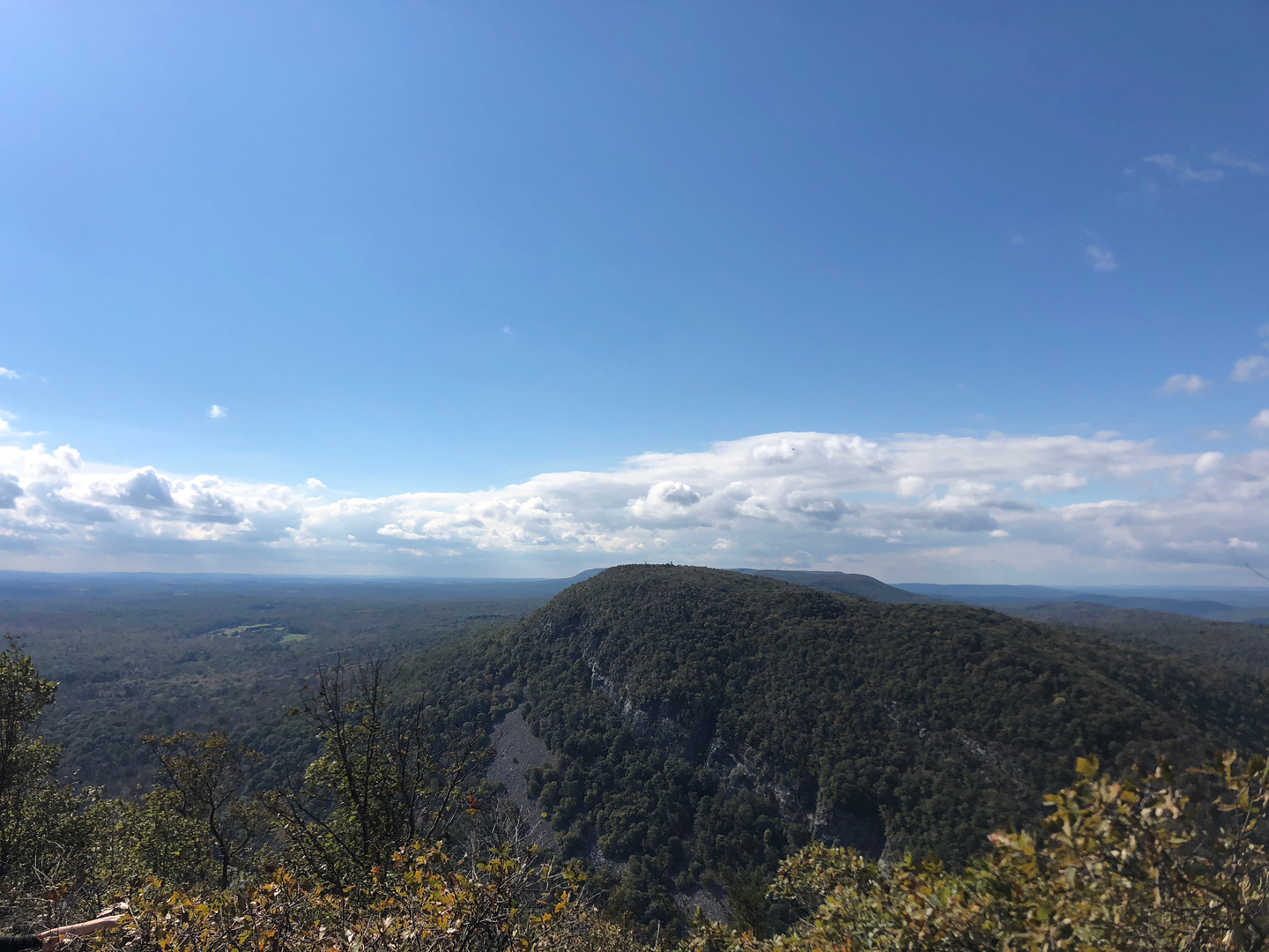
Ridge and viewpoints (the payoff)
Near the top, the trail reaches open rock with expansive views. The classic overlook looks across the river to Mount Minsi on the Pennsylvania side, with I‑80 and the river far below. On clear days, you can trace the ridge lines and see how the “gap” forms a natural passage through the mountains.
Plan to spend time here, but be cautious: - Cliff edges are abrupt and can be slick with dew, rain, or ice. - Wind exposure is higher on open rock—bring a layer even on warm days. - In shoulder seasons, thin ice can linger in shaded cracks while the rest of the rock looks dry.
Descent and return: Pahaquarry Trail (more gradual, still technical)
After the summit area, the loop typically transitions onto the Pahaquarry Trail for a longer, more moderate descent. The footing generally becomes less relentlessly steep than the ascent route, but it’s not a “walk in the park”—you’ll still deal with: - Rocky sections and uneven tread - Leaf cover that can hide ankle-turning rocks in autumn - Wet roots and slick stones near drainages
You’ll pass through quieter forest with a more “ridge-walk” feel at times, then gradually drop back toward the Dunnfield Creek area. Depending on the exact connectors used, you may rejoin near the creek corridor and return to the parking area.
Landmarks, nature, and wildlife to look for
- Delaware Water Gap vistas: The signature feature—an iconic river-cut notch through the ridge.
- Ridgetop oak forest: Drier, wind-pruned trees near exposed rock.
- Spring wildflowers: Look for ephemeral blooms in richer soils lower down (timing varies year to year).
- Wildlife: White-tailed deer are common. You may spot hawks and ravens riding thermals near the cliffs. In warmer months, timber rattlesnakes can occur in rocky ridge habitats in this region—watch where you place hands and feet on sun-warmed rocks, and give any snake a wide berth.
Historical significance of the area
The Delaware Water Gap has long been a natural corridor through the Appalachians. Indigenous peoples traveled and lived in the Delaware River valley for thousands of years, and later the gap became a key passage for regional movement and commerce. Today, the area is protected as part of the Delaware Water Gap National Recreation Area, preserving both the scenic river landscape and the ridge ecosystems that make this hike so distinctive.
Planning notes

Surfaces
Ground
Unknown
Dirt
Wood
Comments and Reviews
User comments, reviews and discussions about the Mount Tammany via Mount Tammany Trail and Pahaquarry Trail, New Jersey.
average rating out of 5
0 rating(s)