Carris Hill and Wyanokie High Point via Macopin Trail and Wyanokie Circular Trail
Download
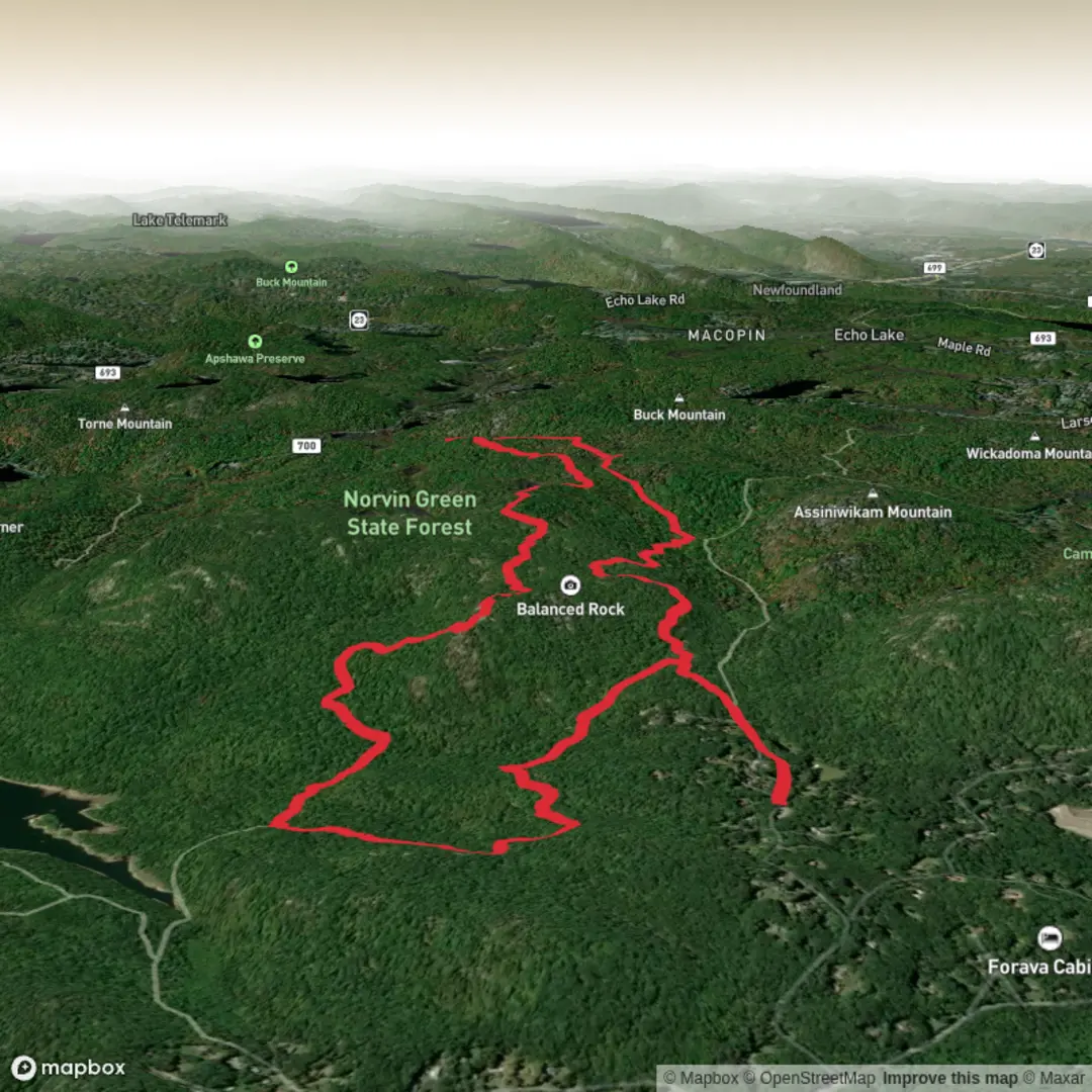
3D Preview
Add to list
More
11.4 km
~2 hrs 57 min
412 m
Loop
“Rock-hop rugged ridgelines between Carris Hill and Wyanokie High Point for hard-won, sweeping views.”
This medium loop links two of the best viewpoints in the Wyanokie Wilderness—Carris Hill and Wyanokie High Point—using the Macopin Trail and the Wyanokie Circular Trail. Expect a rugged, rocky ridgeline feel typical of the New Jersey Highlands: short, steep pitches, frequent stone steps and boulder-hopping, and long stretches of forested singletrack. At around 11 km (6.8 mi) with roughly 400 m (1,300 ft) of total climbing, it’s a steady workout rather than a long-distance day.
Getting to the start (car + public transport)
Nearest well-known start area: the most common and practical access for this route is from the Otter Hole / Wyanokie Wilderness trailhead area in Norvin Green State Forest (Ringwood, NJ), near Otter Hole Road and the Wanaque Reservoir. If you’re using HiiKER to load the route, match the start point to the closest marked trailhead/parking shown for Wyanokie Wilderness / Otter Hole.
- By car: Aim for the Norvin Green State Forest – Otter Hole / Wyanokie Wilderness parking area off Otter Hole Road (Ringwood, NJ). Parking is limited and fills quickly on fair-weather weekends; arrive early. Roads in this part of the Highlands are narrow and wooded—drive slowly, especially at dawn/dusk for wildlife.
- By public transport: Public transit is possible but inconvenient. The most realistic approach is to take NJ Transit rail or bus to a nearby town such as Wanaque or Ringwood, then use a rideshare/taxi to reach the Otter Hole trailhead area. Plan for spotty cell service near the forest; arrange your return pickup timing conservatively.
What the terrain feels like
The New Jersey Highlands are old, hard bedrock country. Trails here often run over gneiss and granite-like outcrops, with loose angular rock, rooty tread, and occasional wet seeps. Even when the mileage is modest, the footing can slow your pace. After rain, expect slick rock and muddy pockets in low spots; in winter, freeze–thaw can turn shaded sections into persistent ice.
Route flow and key landmarks (with approximate distances)
0.0–2.0 km (0.0–1.2 mi) | Warm-up through mixed forest, gentle-to-moderate climbing (~80–120 m / 260–390 ft gain)
From the trailhead area, the Macopin Trail typically starts with a forested approach—oak, maple, and hemlock pockets depending on the exact line—before the grade begins to bite. Early on, you’ll likely cross or skirt small drainages that feed the Wanaque watershed. Listen for woodpeckers and spring peepers in season.
2.0–4.5 km (1.2–2.8 mi) | Steeper pitches onto Carris Hill (~150–200 m / 490–650 ft gain over this segment)
As you climb toward Carris Hill, the trail becomes more “Highlands classic”: rock ledges, short scrambles, and frequent micro-ups and downs. Carris Hill’s open rock provides one of the first big rewards—broad views over the surrounding ridges and, in clearer openings, toward the reservoir and the patchwork of forested hills. Wind exposure can be noticeable here even on mild days; bring a light layer.
4.5–7.0 km (2.8–4.3 mi) | Ridge travel and the approach to Wyanokie High Point (rolling, rocky, slower going)
Between the two high points, the route tends to undulate along the ridge system. This is where hikers often underestimate time: the elevation profile may look moderate, but the footing demands attention. Watch for:
- Rock slabs that become slick with leaf litter
- Narrow notches where water collects and mud persists
- Blowdowns after storms (common in shoulder seasons)
7.0–8.5 km (4.3–5.3 mi) | Wyanokie High Point (~80–120 m / 260–390 ft gain)
Wyanokie High Point is a standout viewpoint—an open, rocky perch with a “big country” feel despite being in northern New Jersey. On clear days, you can pick out multiple ridge lines stepping away into the distance. This is a good place for a longer break, but keep an eye on weather: exposed rock is not where you want to be during thunderstorms.
8.5–11.0 km (5.3–6.8 mi) | Descent via the Wyanokie Circular Trail (net downhill with a few sting-in-the-tail bumps)
The return leg generally trends downhill, but don’t expect a smooth cruise. Descents here can be as demanding as climbs—steep, rocky chutes and uneven stone steps can be hard on knees and ankles. Trekking poles help many hikers on this section. Near lower elevations, you may pass wetter ground and denser understory; mosquitoes and ticks can be more noticeable in warm months.
Nature and wildlife to look for
This area sits in the New Jersey Highlands, a region known for extensive forests and important drinking-water watersheds.
- Forest: Predominantly hardwoods (oak, maple, birch), with evergreen pockets. In autumn, leaf cover can hide rocks and holes—slow down.
- Wildlife: White-tailed deer are common. Black bears live in this region; sightings are possible though most bears avoid people. Keep food secured and give

Surfaces
Unpaved
Ground
Unknown
Comments and Reviews
User comments, reviews and discussions about the Carris Hill and Wyanokie High Point via Macopin Trail and Wyanokie Circular Trail, New Jersey.
average rating out of 5
0 rating(s)