Download
3D Flyover
Add to list
More
24.3 km
~2 days
1763 m
Multi-Day
“Embark on the historical and rugged Bonanza Trail for an epic adventure through Nevada's scenic and wild backcountry.”
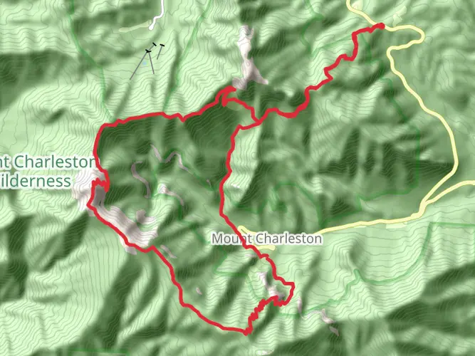
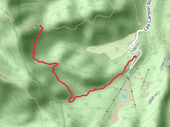
The Bonanza Trail is a challenging point-to-point hike located near Clark County, Nevada, offering an adventurous trek through the Spring Mountains National Recreation Area. Spanning approximately 24 kilometers (15 miles), this trail presents an elevation gain of around 1700 meters (5577 feet), which places it in the category of extra difficult hikes. It's a demanding route that requires good physical condition and proper preparation.
Getting to the Trailhead To reach the trailhead, hikers can drive to a location near Cold Creek, Nevada. From Las Vegas, take US-95 N towards Reno for about 30 miles, then turn left onto Cold Creek Road and continue for about 16 miles. The road will lead you to the small community of Cold Creek, and from there, the trailhead is accessible via a dirt road that may require a high-clearance vehicle. There is no direct public transportation to the trailhead, so a personal vehicle or a taxi service is necessary.
Navigating the Trail Hikers should prepare to navigate the trail with a reliable GPS tool. HiiKER is an excellent resource for trail maps and navigation, ensuring that you stay on the correct path throughout your journey. The trail is not always well-marked, so having a digital map on hand is crucial.
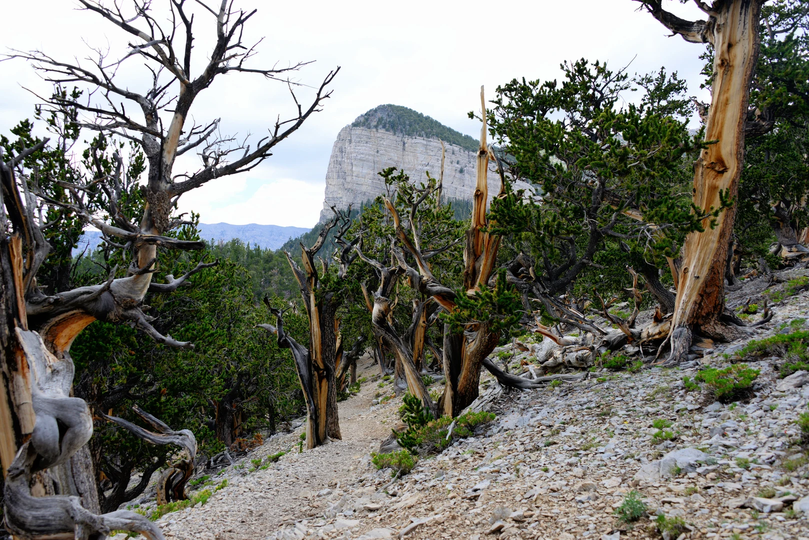
Trail Experience The Bonanza Trail offers a mix of challenging ascents, serene forested areas, and panoramic views. As you begin your hike, the initial few kilometers will introduce you to the local flora, including bristlecone pines and junipers. The ascent is steady, and you'll quickly gain elevation, offering views of the surrounding mountains and valleys.
Historical Significance The area is steeped in history, with the trail itself named after the mining boom of the late 1800s and early 1900s. The Spring Mountains were once the center of a mining frenzy, with the most notable commodity being silver. Hikers will encounter remnants of this era, including old mines and ghost towns, which serve as a reminder of the region's rich past.
Wildlife and Nature As you progress along the trail, keep an eye out for the diverse wildlife that inhabits the area. It's not uncommon to spot mule deer, wild horses, and even the elusive bighorn sheep. Birdwatchers will also appreciate the variety of bird species that can be observed, especially in the early morning hours.
Landmarks and Scenery One of the most significant landmarks you'll encounter is McFarland Peak, a prominent feature in the Spring Mountains. The trail doesn't summit McFarland Peak, but it offers stunning views of it, especially as you approach the halfway point of the hike. Additionally, the trail provides vistas of the Las Vegas Valley and, on clear days, the distant Death Valley.
Preparation and Safety Given the trail's difficulty and remote nature, it's essential to be well-prepared. Carry plenty of water—at least 4 liters per person—as there are no reliable water sources along the route. Dress in layers, as temperatures can fluctuate, and be prepared for sudden weather changes. It's also advisable to inform someone of your hiking plans and expected return time.
Seasonal Considerations The best time to hike the Bonanza Trail is from late spring to early fall. Snow and ice can make the trail treacherous in winter, and the summer heat can be intense. Always check the weather forecast before setting out and start early in the day to avoid the midday sun.
Remember, the Bonanza Trail is a backcountry experience that requires respect for the environment and adequate preparation. With the right planning and a sense of adventure, hikers will find this trail to be a rewarding challenge.

What to expect?
Activity types
Frequently asked questions
How long is the Bonanza Trail in Clark County, Nevada?
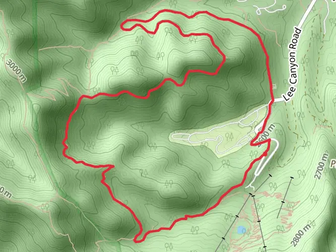
The Bonanza Trail is 24.32 km long, or about 15.1 miles. It is a point-to-point route in the Spring Mountains National Recreation Area, running from the Cold Creek side toward the Bristlecone Trail area near Lee Canyon, so many hikers plan a shuttle rather than a simple out-and-back.
How hard is the Bonanza Trail and how much elevation does the Bonanza Trail gain?
The Bonanza Trail is rated Extra Difficult and gains about 1,763 m, which is roughly 5,784 feet. That combination of length and climbing makes it a strenuous mountain route better suited to strong hikers with solid fitness, especially on a full point-to-point day.
Where is the Bonanza Trail trailhead and where do you park for the Bonanza Trail?
The main Bonanza Trailhead is near Cold Creek in the Spring Mountains National Recreation Area. From US-95, Cold Creek Road leads through the community and continues as Forest Road 45202 to the end of the road at the trailhead; the Forest Service lists the site at about 36.3826, -115.7406 and notes that it is open 24 hours a day.
Is the Bonanza Trail a loop, out-and-back, or point-to-point hike?
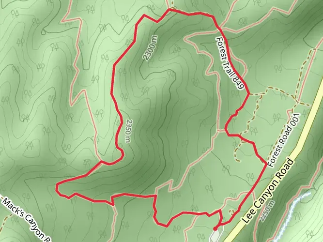
The Bonanza Trail is best treated as a point-to-point hike. The route starts near Cold Creek, climbs switchbacks toward the ridgeline behind Bonanza Peak, passes Wood Spring and McFarland Peak, then reaches the Bristlecone Trail junction near Lee Canyon rather than circling back to the same trailhead.
Are dogs allowed on the Bonanza Trail?
Dogs are allowed at the Bonanza Trailhead, but the Forest Service requires them to be on a leash at the trailhead. Because this route enters the Mt. Charleston Wilderness and covers long, steep terrain with no potable water at the trailhead, it is not a casual dog walk even where dogs are permitted.
Is there water or a restroom at the Bonanza Trail trailhead?
The Bonanza Trailhead does not have potable water or restrooms. That means all drinking water needs to be carried in or treated from backcountry sources, and trailhead logistics should be planned with no toilet, no tap, and no picnic-table infrastructure.
When is the best time of year to hike the Bonanza Trail?
The Bonanza Trailhead is generally open year-round as weather and conditions allow, but the best hiking window is usually the snow-free season. Because the route climbs high into the Spring Mountains and the Forest Service notes winter use such as snowshoeing and cross-country skiing in the area, snow and icy conditions can make the trail much more serious outside the warmer months.
Comments and Reviews
User comments, reviews and discussions about the Bonanza Trail, Nevada.
4.71
average rating out of 5
21 rating(s)