Download
3D Flyover
Add to list
More
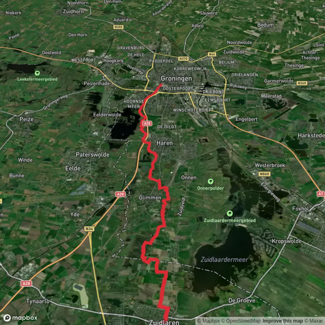
21.0 km
~4 hrs 12 min
0 m
Point-to-Point
“A gentle borderland ramble from village lanes to wind-swept peat meadows, quiet woods, and Groningen’s lively finish.”
This is a mostly flat, low-effort point‑to‑point walk through the Drenthe–Groningen border landscape: village edges, open peat-meadow nature reserves, small lakes and reedbeds, then long, quiet stretches of woodland before you finish in the city of Groningen. At ~21 km (about 13.0 mi) with roughly 0 m (0 ft) of climbing, it’s ideal when you want distance without hills—just plan for wind exposure across the open fields and potentially muddy sections in wetter months.
Getting to the start (Zuidlaren area)
By public transport - Train + bus: The nearest major rail hub is Groningen Centraal. From there, frequent regional buses run south toward Zuidlaren (typically via Haren/Glimmen or via the N34 corridor depending on the line). Get off in/near Zuidlaren village center (look for stops around the main shopping street and Brink area), then walk a few minutes to your chosen trailhead. - From Assen: Buses also connect Assen to Zuidlaren; check schedules for the day and time you’re hiking.
By car - Zuidlaren is easily reached via the N34. Parking is usually simplest near the Brink (village green) or other signed public car parks in the center. If you’re finishing in Groningen, consider leaving the car in Groningen and bussing to Zuidlaren first, so you don’t have to backtrack at the end.
Nearest landmark for the start - If your “hike head” is unspecified, the most practical, well-known starting reference in Zuidlaren is Brink, Zuidlaren (the central village green and event space). It’s a clear meeting point with services nearby.
What to expect underfoot and on the horizon (0–7 km / 0–4.3 mi)
Leaving Zuidlaren, you’ll quickly trade village streets for quiet lanes and farm tracks. The terrain is characteristically flat—expect long sightlines, drainage ditches, and the classic patchwork of northern Dutch farmland. In wet periods, the edges of tracks can be soft; waterproof shoes or light boots help even on an “easy” profile.
As you approach the Wolddeelen area, the landscape becomes more “watery”: peaty meadows, reed fringes, and small pools. This is the kind of country where the weather is a major factor—wind can be the biggest “difficulty” on an otherwise gentle day.
Wildlife to look for - Birdlife is the headline here: herons, egrets, geese, and a variety of ducks are common around open water and reedbeds. - In quieter moments you may spot roe deer at field edges, especially early or late in the day. - Expect plenty of frogs and other amphibians near ditches and wet ground in spring and early summer.
Wolddeelen and the peat-meadow character (7–12 km / 4.3–7.5 mi)
This middle portion is defined by open nature reserve scenery—low vegetation, wet grassland, and water features that can feel surprisingly remote despite being close to towns. The walking is straightforward, but pay attention at junctions where multiple farm tracks run parallel; it’s easy to drift onto the “wrong” line without noticing.
If you’re navigating, load the route in HiiKER and keep an eye on: - Track splits where one option stays on a raised farm road and another drops closer to wet ground - Small bridges/culverts over drainage channels (these can be the “real” crossing points)
Practical notes - Shade is limited here. On sunny days, bring sun protection; on colder days, windproof layers matter more than insulation. - After rain, some sections can be slick with mud even though there’s no climbing.
Noordlaarder Bosch: woodland walking and a change of mood (12–17 km / 7.5–10.6 mi)
The transition into Noordlaarder Bosch is a noticeable shift: from open, bright polder-like views to sheltered forest paths. Underfoot you’ll typically find firmer ground—packed earth, leaf litter, and occasional sandy patches—though puddles can linger in low spots.
This is the most “immersive nature” segment of the day: - Expect mixed woodland with a calmer soundscape and less wind. - Watch for narrower trails and occasional roots; still easy, but you’ll want to place your feet more carefully than on the farm tracks.
Wildlife - Woodland birds (woodpeckers, tits, finches) are common. - Deer are possible; keep voices low if you’re hoping to see them.
Into Groningen: paths, parks, and city finish (17–21 km / 10.6–13.0 mi)
As you leave the forest, the route gradually becomes more urban: paved cycle paths, residential edges, and greener corridors leading toward Groningen. The final kilometers are typically the easiest for navigation because infrastructure becomes clearer, but you’ll share space with cyclists—stay predictable, keep right, and be extra cautious at crossings.
If you’re finishing near Groningen’s central areas, you’ll have abundant options for food, water, and onward transport at the end—useful if you’re treating this as a one-way hike.
Landmarks and historical context to enrich the walk
This route sits in the broader Drenthe–Groningen cultural landscape, shaped by centuries of: - Peat extraction and drainage: The

Surfaces
Unknown
Asphalt
Sand
Concrete
Gravel
Paved
Wood
Comments and Reviews
User comments, reviews and discussions about the Zuidlaren to Groningen via Wolddeelen and Noordlaarder Bosch, Netherlands.
average rating out of 5
0 rating(s)