Download
3D Flyover
Add to list
More
20.2 km
~4 hrs 2 min
0 m
Point-to-Point
“Drifting past wide skies, grazing cattle, and tranquil canals, this peaceful path captures Drenthe’s quiet charm.”
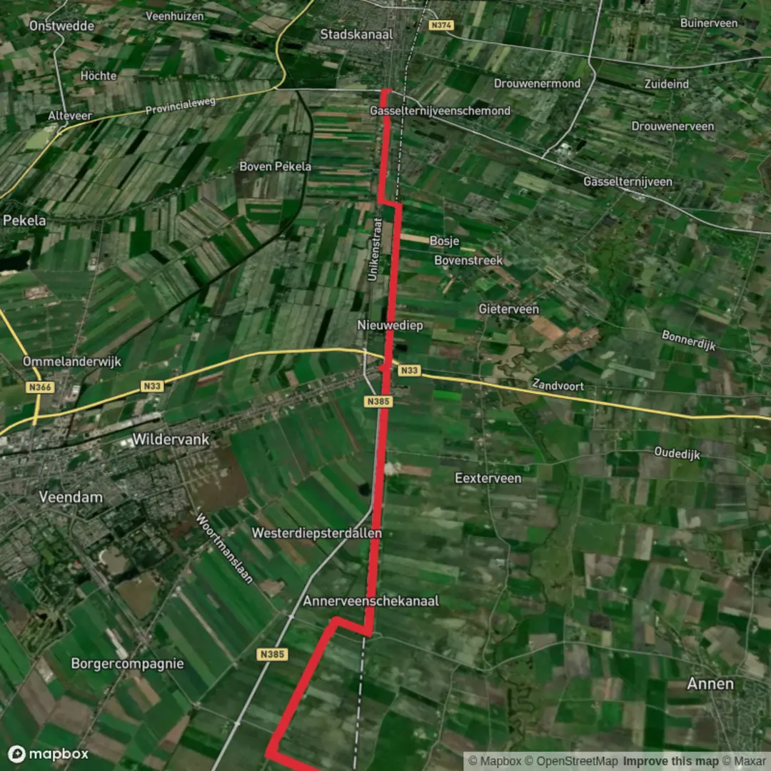
Starting from the small village of Zuidlaarderveen, this gentle 20 km (about 12.4 miles) route meanders through the tranquil landscapes of the Drenthe and Groningen provinces in the Netherlands, with virtually no elevation gain—perfect for those seeking a relaxed, scenic walk. The trailhead is easily accessed near the intersection of Zuidlaarderveen’s main road and the Zuidlaarderweg, a short distance from the Zuidlaardermeer lake, a well-known local landmark.
Getting There
For those arriving by public transport, Zuidlaarderveen is best reached via bus from Groningen or Assen, both of which are major train hubs. Buses run regularly to Zuidlaarderveen, with stops close to the village center. If driving, parking is available near the village’s main street, close to the Zuidlaarderweg, making it convenient to start your hike.
Trail Overview and Navigation
The route is predominantly flat, following a mix of quiet country roads, grassy dikes, and canal-side paths. Navigation is straightforward, but for precise wayfinding and to track your progress, HiiKER offers detailed maps and GPS guidance for this trail.
Landscapes and Nature
Leaving Zuidlaarderveen, the path quickly immerses you in the open peatlands and reclaimed agricultural fields that define this region. The area is part of the Hunze Valley, a landscape shaped by centuries of peat extraction and water management. Expect to see wide skies, grazing cattle, and a patchwork of canals and drainage ditches. Birdlife is abundant, especially in spring and autumn, with marsh harriers, lapwings, and herons commonly spotted along the waterways.
Nieuwediep and the Peat History
At roughly the halfway point, you’ll pass through Nieuwediep, a small canal village that owes its existence to the peat industry. The canal itself was dug in the 19th century to transport peat, and remnants of this history are visible in the linear layout of the village and the old lock structures. Nieuwediep is a good spot for a rest, with benches along the water and a small café open seasonally.
Continuing to Eerste Dwarsdiep
The second half of the hike continues along the canal, with the landscape gradually transitioning to more open farmland and scattered woodlots. The route remains flat and easy, with well-maintained paths. The final stretch leads you to Eerste Dwarsdiep, a hamlet near the intersection of Eerste Dwarsdiep canal and the N366 road, close to the village of Stadskanaal. This area is another testament to the region’s water management heritage, with straight canals and dikes dominating the scenery.
Wildlife and Points of Interest
Keep an eye out for roe deer in the early morning or late afternoon, and listen for the calls of reed warblers and bitterns in the marshy patches. The canals themselves are home to waterfowl and, in summer, dragonflies and damselflies are abundant. The route is also dotted with traditional Dutch farmhouses and windmills, offering plenty of photo opportunities.
Practical Tips
There are limited facilities along the route, so bring enough water and snacks for the day. The terrain is suitable for all fitness levels, and the lack of elevation makes it accessible for families and casual walkers. Waterproof footwear is recommended in wetter months, as some sections near the canals can be muddy.
For navigation and up-to-date trail conditions, consult HiiKER before setting out. The trail is best enjoyed from late spring to early autumn, when the fields are green and the wildlife most active.

Surfaces
Unknown
Asphalt
Concrete
Wood
Comments and Reviews
User comments, reviews and discussions about the Zuidlaarderveen to Eerste Dwarsdiep via Nieuwediep, Netherlands.
average rating out of 5
0 rating(s)