Download
3D Flyover
Add to list
More
17.5 km
~3 hrs 30 min
0 m
Loop
“A breezy loop across Groningen’s sea-flat polders, linking a storied borg, dikes, canals, and big skies.”
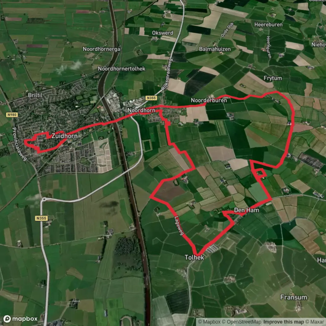
You’ll be walking in the wide-open, sea-shaped lowlands of Groningen’s Westerkwartier, where the land is almost ruler-flat and the “height” comes more from dikes, canal banks, and old settlement mounds than from hills. For an ~18 km (11.2 mi) loop with essentially no climbing (about 0 m / 0 ft of gain), expect easy footing, big skies, and long sightlines—plus a few standout cultural landmarks that make the kilometres pass quickly.
The most practical “anchor” for this loop is Piloersemaborg (Hamsterborg) in Den Ham, a 17th‑century borg (manor/castle) that now operates as a hotel/restaurant. The nearest clear address to use for planning and navigation is: Piloersemaborg, Sietse Veldstraweg 25, 9833 TA Den Ham (near Aduard), Netherlands. (piloersema.nl)
Getting to the start (car + public transport)
By car
- Set HiiKER (or your car GPS) to Sietse Veldstraweg 25, 9833 TA Den Ham. There is typically parking associated with the borg/restaurant area, and it’s a common place to begin local walks. (piloersema.nl)
- From the city of Groningen, Den Ham is a short drive west/northwest into the Westerkwartier countryside.
By public transport - The easiest approach is usually train/bus to the Zuidhorn/Noordhorn area, then a short taxi or local bus connection toward Den Ham (near Aduard). Rural services can be infrequent, so check the day’s timetable before committing to a specific departure. (If you tell me where you’re coming from—e.g., Groningen Centraal—I can outline the most straightforward connection pattern.)
What the route feels like underfoot
Because the landscape is so flat, the “difficulty” comes less from elevation and more from: - Distance and exposure: 18 km (11.2 mi) is still a solid half-day for many walkers, and wind can be the real workout here. - Surface variety: expect a mix of paved farm lanes, compacted paths on dikes/canal edges, and occasional softer verge sections. After rain, some field-edge stretches can be slick or muddy. - Navigation simplicity with a catch: the terrain is open and the network of straight lanes can look similar. Use HiiKER to stay on the intended loop and avoid accidentally adding extra kilometres on parallel farm roads.
Landmarks and scenery you’ll pass
Piloersemaborg (Hamsterborg) – the cultural highlight (0–2 km / 0–1.2 mi) Starting near the borg gives you an immediate sense of the region’s wealth and history. The building dates to 1633 and represents the “borg” tradition of Groningen—manor houses tied to landownership and farming estates. It’s also described as the last “farmborg” in the Netherlands, which is part of what makes it such a notable stop. (en.wikipedia.org)
Open polder views and historic landscape patterns (roughly 2–12 km / 1.2–7.5 mi) You’re walking through (and alongside) one of the Netherlands’ most historically layered rural areas. The broader region connects to National Landscape Middag‑Humsterland, often described as the oldest cultural landscape in the Netherlands, shaped by former sea channels, winding roads, and settlement mounds (“wierden”) where people lived to stay above floodwaters. Even when you’re not standing on a mound, you’ll notice how roads and ditches trace older natural lines rather than modern grids. (visitgroningen.nl)
Noordhorn – canal-side village character (roughly 12–16 km / 7.5–10 mi) As you swing toward Noordhorn, the scenery becomes more “village-and-water” focused. Noordhorn sits at about 2 m (6–7 ft) above sea level, and its history is closely tied to waterways and regional conflict. The village is separated from Zuidhorn by the Van Starkenborgh Canal, and the area saw the Battle of Noordhorn (30 September 1581) during the Dutch Revolt. Even if your loop doesn’t pass a specific battlefield marker, knowing this was contested ground adds

Surfaces
Asphalt
Unknown
Concrete
Comments and Reviews
User comments, reviews and discussions about the Ijsbaan, Piloersemaborg and Noordhorn Loop, Netherlands.
average rating out of 5
0 rating(s)