Download
3D Flyover
Add to list
More
13.0 km
~2 hrs 36 min
0 m
Loop
“Stride beneath vast coastal skies through flat reedbeds and wet grasslands—wind and wildlife keep it adventurous.”
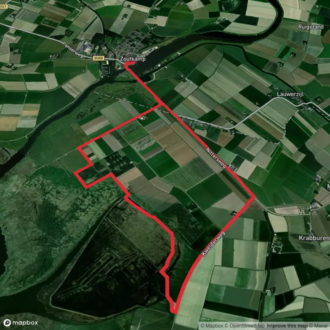
You’ll be walking through the wide-open southern edge of Nationaal Park Lauwersmeer, where the land is almost perfectly flat and the “elevation gain” is essentially 0 m (0 ft)—but don’t let that fool you: wind, wet ground, and big skies can make this feel like a real coastal expedition. At roughly 13 km (about 8.1 miles), the Kollumerwaard Loop is an easy, steady day out with huge views over reedbeds, wet grasslands, and open water, plus some of the best birdlife in the northern Netherlands.
Getting to the start (car + public transport)
Most practical start area: the Kwelderweg access points near Kollumerpomp (a tiny settlement on the Friesland/Groningen edge of the park). A commonly used trailhead for routes in this area is the parking area on Kwelderweg near Kollumerpomp (Staatsbosbeheer lists a start at Kwelderweg, 9293 MJ, between Dokkumer Nieuwe Zijlen and Zoutkamp). (staatsbosbeheer.nl)
A major landmark you can also aim for is Uitkijktoren De Baak (De Baak lookout tower) near Munnekezijl, reached from the same Kwelderweg corridor; signage may mention “Kollummerwaard Natuurbeleving.” (visitwadden.nl)
- By car: From the regional road network, you’ll typically approach via Buitenpost → N358 toward Dokkumer Nieuwezijlen, then turn onto Kwelderweg toward Zoutkamp; after several kilometers you’ll see small parking areas and nature signage for Kollumerwaard/De Baak. (visitwadden.nl)
- By public transport: The park edge is rural and buses can be infrequent. The most reliable approach is usually train to Buitenpost (or another nearby rail station such as Grijpskerk depending on your direction), then a bus/taxi toward Kollumerpomp / Dokkumer Nieuwe Zijlen, finishing with a short road-walk to Kwelderweg. Check same-day schedules before committing.
For navigation, download the route to HiiKER before you arrive—mobile signal can be patchy in open wetland, and the maze of dikes, grazing enclosures, and seasonal path closures can make “obvious” lines on the ground misleading.
What the loop feels like underfoot
Expect a mix of: - Dike-top tracks and grassy farm-style access lanes (fast, exposed to wind) - Unpaved wetland paths that can be soft, muddy, or waterlogged after rain or in winter - Short sections where the “path” is more like a trodden line through grass/reed edge, especially near the Middelplaat shoreline in parts of Kollumerwaard (some stretches are not hardened). (friesland.nl)
Even though the route is rated easy, footwear matters: waterproof hiking shoes are usually enough in dry spells; in wetter months, boots can be the difference between comfortable and miserable (the approach to De Baak is specifically noted as sometimes difficult due to wet ground and grazing impacts). (visitwadden.nl)
Kilometer-by-kilometer expectations (approximate)
Because this landscape is flat and open, the “high points” are mostly view mounds, dikes, and lookout structures rather than hills.
0–2 km (0–1.2 mi): Settling into the polder-wetland edge
You’ll leave the roadside/parking area and quickly enter a broad, treeless scene: wet grassland, reedbeds, drainage channels, and long sightlines. In calm weather it feels serene; in wind it can feel surprisingly committing because there’s little shelter.2–6 km (1.2–3.7 mi): Reedbeds, open water, and grazing zones
This is classic Lauwersmeer habitat—marsh and reed with open water nearby. The park uses large grazers to keep the landscape open (preventing scrub and woodland from taking over), so you may share the area with Konik horses and Scottish Highland cattle. (friesland.nl)
Give them space, don’t try to pass between animals, and be especially cautious if you encounter calves.**6–8 km (3.7–5.0 mi): Lookout focus—De Baak area (

Surfaces
Asphalt
Concrete
Unknown
Grass
Wood
Comments and Reviews
User comments, reviews and discussions about the Kollumerwaard Loop, Netherlands.
average rating out of 5
0 rating(s)