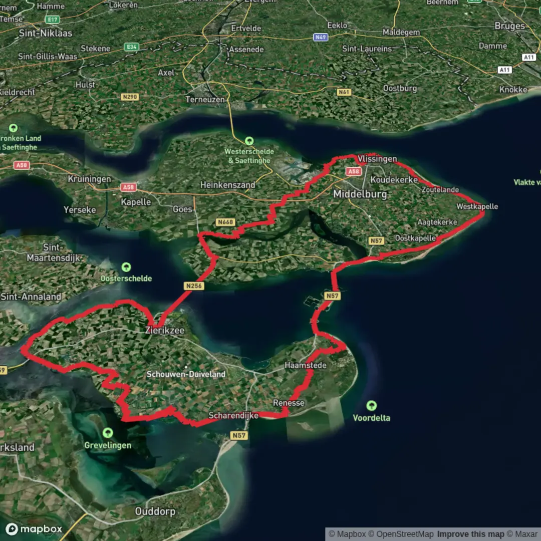
Zeeland Bridge, Europapad West, Zwanenburg, Strand Zoutelande and Schelpweg Loop
Download
3D Flyover
Add to list
More
165.9 km
~6 days
29 m
Multi-Day
“A long, low-lying Dutch ramble along dikes, dunes and polders—where wind, not hills, leads.”
This is a long, low-relief Netherlands walk of roughly 166 km / 103 miles with essentially 0 m / 0 ft of cumulative climbing—not because it’s perfectly flat every step, but because the route spends so much time on dikes, dunes, reclaimed polders, and coastal paths that any ups and downs tend to cancel out. Expect a mix of hard-surfaced dike tops, compact gravel, dune sand, and village pavements, with frequent opportunities to resupply.
Because the “hike head” and exact start coordinates weren’t provided, the most practical anchor points implied by the route name are:
- Zeeland Bridge (Zeelandbrug / Oosterscheldebrug) on the N256 between Zierikzee and Noord-Beveland (near Colijnsplaat) as the Zeeland-side landmark start area. (structurae.net)
- Zwanenburg / Halfweg-Zwanenburg Station (between Amsterdam and Haarlem) as the North Holland waypoint that suggests a second “chapter” of the loop or a linked segment. (en.wikipedia.org)
- Zoutelande and Schelpweg (Zoutelande area) as the coastal/dune segment on Walcheren. (en.wikipedia.org)
If you share a GPX (or the lon/lat points), I can convert each to the nearest named place/landmark and tighten the stage-by-stage distances precisely; below is a planning-grade description that matches the named places and the overall distance.
Getting to the start (public transport + car)
If starting near Zeeland Bridge (N256):
- By car: Navigate to the Zeelandbrug (N256) area; parking is typically easiest in nearby towns such as Zierikzee or Colijnsplaat, then walk to the bridge approach. (structurae.net)
- By public transport: The most common rail hub is Goes (Zeeland). From there, buses run toward Zierikzee and the N256 corridor; local connections can get you close enough to walk to the bridge approaches.
If starting near Zwanenburg (North Holland):
- By train: Use Halfweg–Zwanenburg Station, which has frequent Sprinter service linking Amsterdam Centraal and Haarlem (roughly every 30 minutes). (en.wikipedia.org)
- By car: Park near the station area or in designated village parking; this is a commuter belt, so be mindful of permit-only streets.
What the walking feels like (surface, exposure, pacing)
Over 166 km / 103 miles, most hikers break this into 5–7 days (about 24–33 km / 15–21 miles per day) depending on daylight, wind, and how much beach/dune sand is included.
- Wind is the real “elevation”: Zeeland’s open water and coastal plains can turn an “easy” profile into a grind. Plan layers and a windproof shell even in mild forecasts.
- Underfoot variety:
- Dike tops & polder roads: fast, firm, sometimes monotonous—great for steady pacing.
- Dune paths near Zoutelande: softer sand patches can slow you down and stress calves/Achilles.
- Village connectors: paved sections through towns where foot fatigue can build; rotate socks and manage hotspots early.
- Dike tops & polder roads: fast, firm, sometimes monotonous—great for steady pacing.
Use HiiKER to keep your line clean through the many junctions where dike paths, farm tracks, and village streets braid together—especially in polder country where everything looks similar in flat light.
Zeeland Bridge to Walcheren coast: big water, dikes, and Delta Works country
Starting around the Zeeland Bridge area, you’re immediately in the landscape shaped by the Southwestern Delta—a region defined by storm-surge risk, engineered defenses, and the constant presence of tidal water. The bridge itself (on the N256) is a major landmark spanning the Oosterschelde. (structurae.net)
What to expect on this portion: - Long, straight horizons with water on one side and reclaimed land on the other. - **Birdlife

Surfaces
Asphalt
Unknown
Concrete
Gravel
Ground
Paved
Cobblestone
Grass
Comments and Reviews
User comments, reviews and discussions about the Zeeland Bridge, Europapad West, Zwanenburg, Strand Zoutelande and Schelpweg Loop, Netherlands.
average rating out of 5
0 rating(s)