Download
3D Flyover
Add to list
More
20.3 km
~4 hrs 4 min
0 m
Point-to-Point
“Follow dike-top tracks beneath vast skies, where shifting wetlands and sand lakes mirror the Rhine’s moods.”
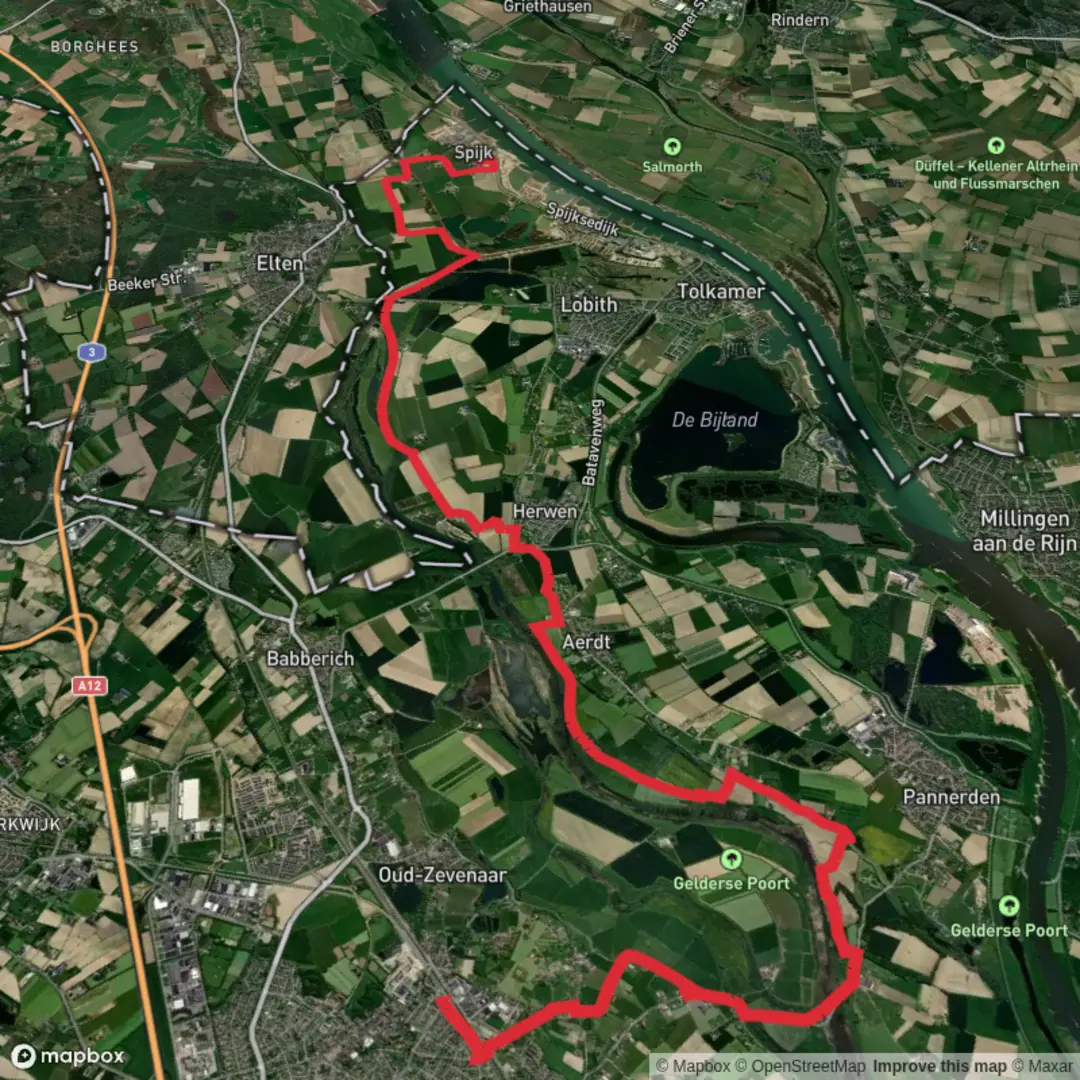
This is a flat, lowland walk through the Dutch–German border landscape east of Arnhem: wide skies, dike-top paths, old river channels, and a patchwork of wetlands, grazing meadows, and sand-extraction lakes. At ~20 km (12.4 mi) with ~0 m / ~0 ft of climbing, it’s more about wind exposure, path surfaces, and seasonal wet ground than physical steepness.
Getting to the start (Zevenaar)
By train (public transport):
Zevenaar has an NS rail station with frequent connections via Arnhem. From Zevenaar Station (Stationsplein, Zevenaar) you can walk a few minutes to the town edge and pick up paths leading toward the Rijnstrangen area. If you’re using HiiKER, set your start point near Zevenaar Station or the nearest mapped trail access on the eastern side of town.
By car:
Aim for parking near the center or station area, such as around Stationsplein, Zevenaar, where you’ll find public parking options and easy access to shops for last-minute supplies. Zevenaar is close to the A12 corridor; expect quick access but also commuter traffic at peak times.
What the route feels like underfoot (and why it’s “easy”)
Most of the day is on level tracks: paved cycle paths, compacted gravel, farm lanes, and dike-top paths. “Easy” here can still mean: - Wind: exposed dikes and open fields can feel harder than the elevation suggests. - Mud/soft verges: after rain, some sections near wetlands and old channels can be slick. - Mixed surfaces: road crossings and short paved stretches are common in this region.
Plan on 4.5–6 hours depending on pace and stops.
0–5 km (0–3.1 mi): Leaving Zevenaar and entering the river landscape
The first few kilometers typically transition from town edges into open countryside. Expect: - Straight, efficient paths (often shared with cyclists). - Drainage ditches and canals paralleling fields—classic Dutch water management scenery. - Early birdlife even before the “wild” sections: gulls, corvids, and in warmer months swallows over fields.
Navigation is generally straightforward, but the density of intersecting farm tracks can be confusing—use HiiKER to confirm you’re taking the correct turn when multiple parallel lanes head the same direction.
5–14 km (3.1–8.7 mi): Oude Rijnstrangen — wetlands, old channels, and big-sky birding
This middle portion is the heart of the walk: Oude Rijnstrangen is part of the broader Rhine floodplain system, shaped by centuries of river movement, dike building, and controlled flooding. The landscape often includes: - Old river arms and wet depressions that hold water seasonally. - Reedbeds, willow scrub, and wet meadows—excellent habitat for waterfowl. - Grazed areas where cattle or horses may be used for conservation management.
Wildlife to look for - Geese, ducks, coots, and herons are common; in migration seasons, numbers can be impressive. - Raptors (buzzards, kestrels) often hunt over open fields. - Amphibians in wetter months; expect frogs in ditches and shallow pools. - Insects: in late spring/summer, bring protection for mosquitoes/gnats near still water.
What to watch out for - Seasonal flooding or saturated paths: even if the route is “flat,” water levels can change quickly in floodplain areas. If a track is waterlogged, detours may be necessary—HiiKER is useful for checking nearby parallel paths. - Electric fences and livestock gates: pass through carefully and close gates behind you. - Limited shade: on sunny days, the open floodplain can feel surprisingly hot.
Historical context This region’s identity is tied to the Rhine’s shifting channels and the Netherlands’ long history of dike construction and water control. Many “natural” looking wetlands here are influenced by engineered hydrology—polders, drainage, and managed flood storage—reflecting centuries of living with (and reshaping) the river.
14–20 km (8.7–12.4 mi): Zandwinning — sand-extraction waters and the run-in to Willibrordusweg
As you approach the zandwinning (sand extraction) area, the scenery often changes from marshy floodplain to larger open water bodies with more industrial origins. These lakes and pits can still be rich for nature: - Clearer, deeper water than the marsh sections. - Open shorelines where you may see terns, gulls, and other waterbirds. - Long, straight embankments that make for fast walking but can be very exposed to wind.
The final kilometers toward Willibrordusweg tend to be on firm tracks and local roads. “Willibrordusweg” is a road name you’ll see in several Dutch towns; for the nearest recognizable reference, treat your endpoint as the mapped road segment labeled Willibrordusweg in the Zevenaar/Rijnstrangen vicinity on HiiKER, and use that to pinpoint the exact finish location for pickup or return transit.
Practical planning: timing, water, and facilities
- Food & water: Once you leave Zevenaar, services can be sparse. Carry enough water for a half-day walk (more in warm weather).

Surfaces
Unknown
Asphalt
Unpaved
Ground
Concrete
Comments and Reviews
User comments, reviews and discussions about the Zevenaar to Willibrordusweg via Oude Rijnstrangen and Zandwinning, Netherlands.
average rating out of 5
0 rating(s)