Download
3D Flyover
Add to list
More
10.5 km
~2 hrs 5 min
0 m
Loop
“Wander through vibrant woodlands, wildflower meadows, and echoes of history on this peaceful Achterhoek loop.”
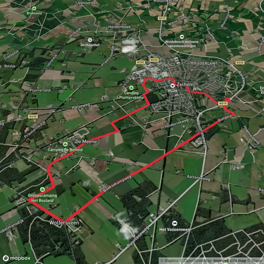
Nestled in the scenic Achterhoek region of Gelderland, the Het Pelikaanbos and Papenborg and Zelhemsche Mark Loop offers a gentle 10 km (about 6.2 miles) circuit with virtually no elevation gain, making it an ideal choice for hikers seeking a leisurely day out in nature. The trailhead is conveniently located near the village of Zelhem, with the closest significant landmark being the historic Sint-Lambertuskerk (St. Lambert’s Church) in the heart of Zelhem. This makes the route easily accessible whether arriving by car or public transport—buses from Doetinchem and Ruurlo stop at Zelhem’s central bus station, just a short walk from the start.
Getting Started and Navigation
The loop begins on the outskirts of Zelhem, where you’ll find ample parking near the village center. For those relying on public transport, the bus stop at Zelhem, Centrum is the most convenient, placing you within a few hundred meters of the trailhead. To ensure you stay on track throughout the walk, use HiiKER for up-to-date navigation and trail information.
Woodlands, Heath, and Farmland
The first section leads you into Het Pelikaanbos, a tranquil woodland area characterized by tall pines, oaks, and birches. The forest floor is often carpeted with moss and ferns, and in spring and summer, wildflowers add bursts of color. Listen for woodpeckers and songbirds, and keep an eye out for roe deer, which are sometimes spotted in the quieter clearings.
After about 3 km (1.9 miles), the trail transitions into open farmland and heath, typical of the Achterhoek landscape. Here, you’ll pass through Papenborg, a patchwork of meadows and hedgerows that support a variety of butterflies and small mammals. The flat terrain and well-maintained paths make this section particularly accessible for families and less experienced hikers.
Historic Zelhemsche Mark
At roughly the halfway point, you’ll enter the Zelhemsche Mark, an area steeped in local history. This region was once part of a medieval common land system, where local farmers grazed livestock and gathered wood. Remnants of old boundary markers and traditional farmhouses can still be seen along the route, offering a glimpse into rural life from centuries past. Interpretive signs provide context about the area’s agricultural heritage and the evolution of land use in Gelderland.
Returning to Zelhem
The final stretch brings you back through mixed woodland and past several small streams, which attract herons and kingfishers. The path is mostly flat and wide, with occasional benches for rest stops. As you approach Zelhem, the spire of Sint-Lambertuskerk comes into view, signaling the end of the loop.
Trail Essentials
With a total distance of 10 km (6.2 miles) and negligible elevation gain, this loop is rated as easy and suitable for most fitness levels. The well-marked paths are accessible year-round, though waterproof footwear is recommended in wetter months due to occasional muddy patches. Facilities such as cafes, shops, and restrooms are available in Zelhem, making it easy to stock up before or after your hike.
For navigation and real-time trail updates, HiiKER is the recommended tool, ensuring you make the most of your walk through this peaceful and historically rich corner of the Netherlands.

Surfaces
Unknown
Asphalt
Concrete
Comments and Reviews
User comments, reviews and discussions about the Het Pelikaanbos and Papenborg and Zelhemsche Mark Loop, Netherlands.
average rating out of 5
0 rating(s)