Download
3D Flyover
Add to list
More
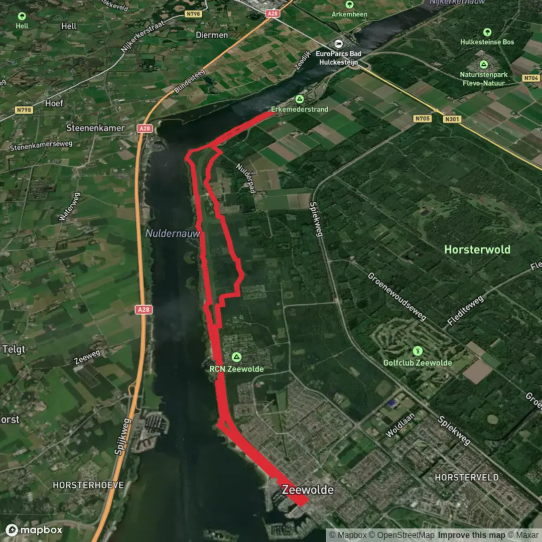
18.0 km
~3 hrs 36 min
0 m
Loop
“A wind-swept dike loop of wide skies, shimmering Randmeren waters, and reedbed birdsong.”
You’re looking at a true “flatlands water-and-dike” walk: ~18 km (11.2 mi) with essentially 0 m / 0 ft of climbing, circling the narrow Randmeren waters around Nulderhoek and the long shoreline of Erkemederstrand. Expect wide skies, constant water views, reedbeds full of birdsong, and long, straight dike sections where wind is the main challenge—not hills.
Nearest start landmark / address (good for navigation and parking):
Erkemederstrand (beach/campsite area), Erkemederweg 79, 3896 LB Zeewolde, Netherlands. (erkemederstrand.nl)
This is the most practical “trailhead” anchor because it’s a well-signed recreation area with established access.
Getting to the start (car + public transport)
By car
- Set your destination to Erkemederweg 79, 3896 LB Zeewolde (Erkemederstrand). (erkemederstrand.nl)
- You’ll typically approach via the N301 and then follow signs for Erkemederstrand after the bridge area. (anwbcamping.nl)
- Parking is usually along/near the Erkemederstrand access; note that some seasons/periods may involve paid entry/parking controls at the recreation area.
By public transport
- The closest useful stop to aim for is “Zeewolde, Nijkerkersluis” (bus stop name). (en.busti.me)
From there, you’re in the right corridor to walk toward the Erkemederstrand/Nuldernauw dike area. (Exact bus lines/timetables change—check your route in advance.)
From the Erkemederstrand access, the loop quickly settles into its rhythm: dike-top walking with water on one side and polder/fields on the other. Underfoot is typically a mix of compacted path, short grass, and occasional paved cycleway segments—easy on the lungs, but the wind can make it feel longer than the distance suggests.
At roughly 0–3 km (0–1.9 mi) you’ll be skirting the long recreational shoreline of Erkemederstrand, known as one of the longest beaches in Flevoland (around 3 km). (fietsnetwerk.nl)
This section is great for warming up: open views across the Nuldernauw and plenty of space. In warmer months, this is also where you’ll notice the area’s heavy recreation use (swimmers, beachgoers, dogs, and cyclists).
By about 3–7 km (1.9–4.3 mi) the feel becomes more “nature-forward” as you move away from the busiest beach access points. The shoreline transitions into reed fringes, wet meadows, and quieter banks—classic Randmeren habitat. The Nuldernauw is part of the Veluwe Randmeren system: a chain of “border lakes” created to separate the low Flevoland polders from the higher mainland and manage water levels. (ecoshape.org)
That engineering history is the backdrop of your entire walk: you’re hiking along a landscape that’s as much designed as it is natural, where water management and recreation share the same narrow strip of land.
Nulderhoek & the bird-rich dike corridor
Around 7–11 km (4.3–6.8 mi) you’ll be near Nulderhoek, where the water narrows and the dike views open up in multiple directions. This is often the most rewarding stretch for wildlife scanning because you can look over: - open water (diving ducks, grebes), - wet meadows (waders), - reedbeds and scrub (warblers and small passerines).
This corridor is well known for waterfowl and marsh birds; species commonly noted in the area include geese and ducks,

Surfaces
Unknown
Concrete
Grass
Ground
Paved
Asphalt
Dirt
Comments and Reviews
User comments, reviews and discussions about the Zeewolde, Nulderhoek and Erkemederstrand Loop, Netherlands.
average rating out of 5
0 rating(s)