Download
Preview
Add to list
More
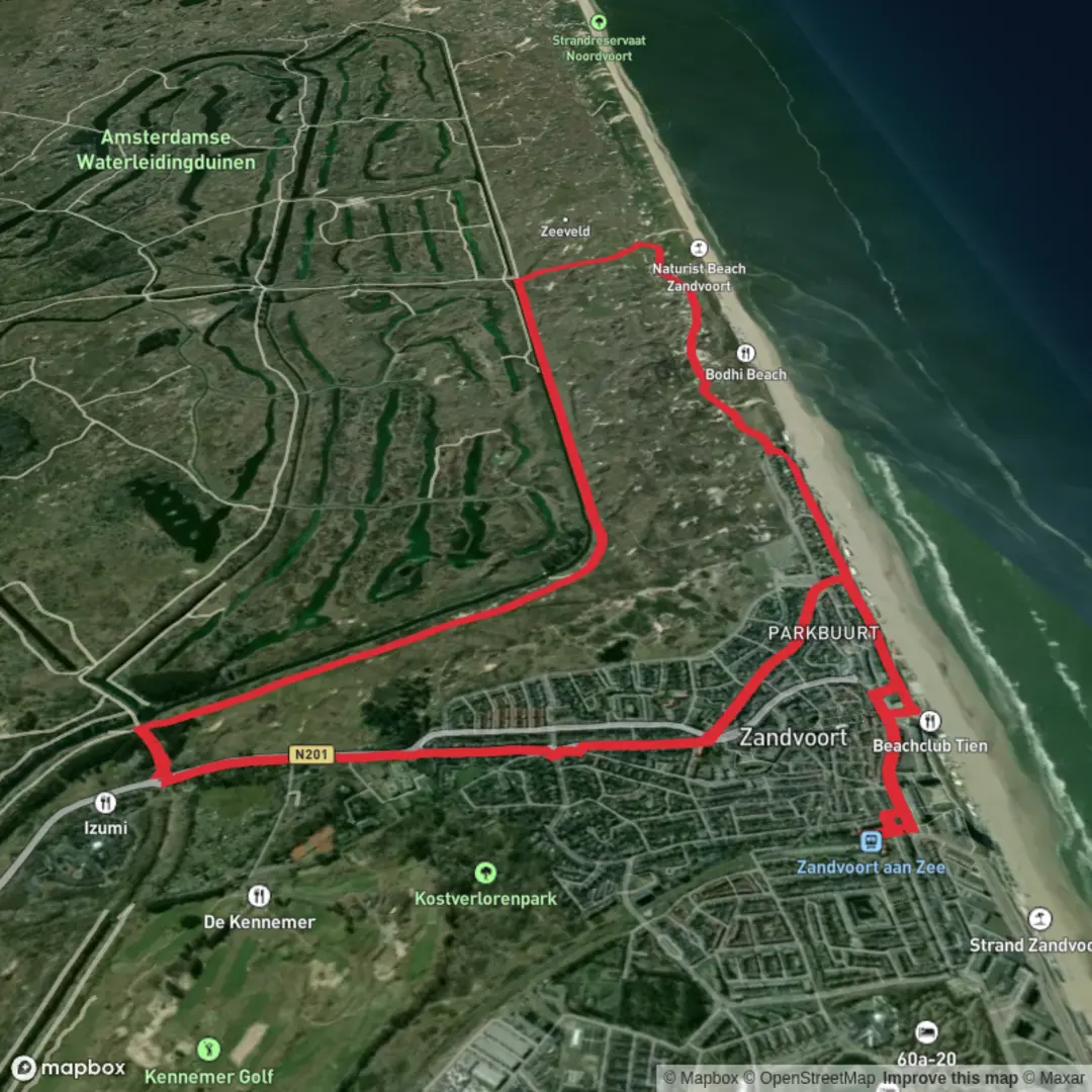
11.8 km
~2 hrs 22 min
6 m
Loop
“Wander Zandvoort’s wind-sculpted dunes—bright sands, quiet hollows, and deer glimpses along easy paths.”
You’ll be walking a classic Dutch coastal-dune circuit: broad, sandy dune ridges, sheltered hollows with scrub and grasses, and (depending on the exact line of the loop) stretches of straight, well-surfaced paths that feel almost park-like. At ~12 km / ~7.5 mi with essentially no meaningful climbing (about 0 m / 0 ft of elevation gain), it’s an easy outing that’s more about wind, sand underfoot, and wildlife-spotting than hills.
Expect a mix of firm gravel/asphalt multi-use tracks and softer sandy footpaths. Even on a “flat” route, dunes can make the effort feel a notch harder if you hit loose sand or a headwind off the North Sea—bring a light wind layer year-round.
Getting to the start (and what “near” usually means here)
This loop name strongly suggests you’re starting around the southern edge of Zandvoort, near the main access points into the Amsterdamse Waterleidingduinen (Amsterdam Water Supply Dunes). A common, easy-to-find landmark start is the Amsterdamse Waterleidingduinen entrance on Zandvoortselaan, by Restaurant De Duinrand, Zandvoortselaan 130, 2042 LK Zandvoort (NL). (inyourpocket.com)
- By public transport: From Zandvoort (and connections via Haarlem/Amsterdam), bus line 80 stops at Zandvoortselaan / New Unicum, which is used as a convenient stop for the Waterleidingduinen entrance area. (visitzandvoort.com)
- By car: There’s paid parking at the Waterleidingduinen entrance on Zandvoortselaan, and also at P De Zuid in Zandvoort (useful if your loop swings closer to town). (visitzandvoort.com)
If you’re loading the route in HiiKER, double-check the exact trailhead pin—Zandvoort has multiple dune access points, and starting at the “wrong” entrance can add a couple of kilometers.
What the walk feels like, kilometer by kilometer
0–3 km / 0–1.9 mi: You’ll ease in on wide, obvious paths at the dune edge. The landscape is immediately “dune country”: marram grass (helmgras) stabilizing sand, low shrubs, and open views where the wind has kept vegetation short. In calm weather it can feel surprisingly quiet just a few minutes from town. (visitzandvoort.nl)
3–7 km / 1.9–4.3 mi: The middle of the loop is where the character usually deepens—more dune hollows, more sheltered stretches, and (if your line enters the Waterleidingduinen) a distinctive pattern of canals/ponds and wet dune slacks tied to the area’s water function. The Amsterdamse Waterleidingduinen are part of the drinking-water system for Amsterdam: water is brought in, infiltrates into the dunes, and is naturally filtered over time before further treatment. (visitzandvoort.com)
This is also prime wildlife territory: keep your pace relaxed and scan ahead on the path edges.
7–10 km / 4.3–6.2 mi: You’ll often get the most “open dune” feeling here—bigger skies, brighter sand, and more exposure. If the route skirts the North Dunes (Noordduinen) side of Zandvoort, you may notice a patchwork of grassland, small pools, and areas with cultural-landscape traces like old fields. (visitzandvoort.com)
10–12 km / 6.2–7.5 mi: The loop typically funnels you back toward the access roads and the town edge. Footing becomes firmer again, and you’ll likely see more day-walkers and families near the entrances.
Landmarks, nature, and wildlife to look out for
- Deer are the headline species in the Waterleidingduinen area; sightings are common enough that many visitors treat it as “deer-guaranteed,” especially around dawn/dusk. (visitzandvoort.nl)
- Foxes, rabbits, and lots of birdlife are also typical in these dune systems; bring binoculars if you enjoy identifying birds. (zandvoort-holland.com)
- Dune vegetation: Marram grass is the key stabilizer on exposed sand; you’ll also see scrub and hardy dune plants adapted to salt spray and wind. (visitzandvoort.nl)
Seasonal note: in early autumn (often September–October), deer rut activity can make wildlife encounters more dramatic—give animals extra space and don’t get between deer on paths.

Surfaces
Unknown
Asphalt
Paved
Cobblestone
Concrete
Comments and Reviews
User comments, reviews and discussions about the Nieuw Duynen and Zandvoort Loop, Netherlands.
average rating out of 5
0 rating(s)