Download
3D Flyover
Add to list
More
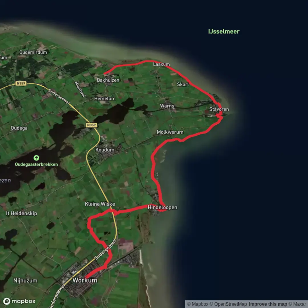
26.8 km
~5 hrs 21 min
0 m
Point-to-Point
“Follow Workum’s watery past along wind-swept dikes to Mirns, where the IJsselmeer horizon widens.”
This is a long, flat coastal-and-polder walk through Southwest Fryslân, linking the old Zuiderzee trading town of Workum with the lakeside village of Mirns, while tracing sweeping bends of the Bocht fan Molkwar and the open horizon of the IJsselmeer. Expect big skies, constant water views, and classic Dutch landscape engineering—dikes, drainage canals, and reclaimed land—rather than climbs.
Distance & ascent: ~27 km / ~16.8 mi, with ~0 m / ~0 ft elevation gain (any “ups and downs” are just dike crests and bridge ramps).
Difficulty: Easy (physically), but exposure to wind and weather can make it feel tougher than the profile suggests.
Getting to the start (Workum)
Start point (practical landmark): Workum railway station (Station Workum), Workum, Friesland, Netherlands — the simplest, most recognizable place to begin and to meet others.
- By public transport: Workum has a train station on the regional line in Fryslân; from there it’s a short walk to the historic center and onward to the dike and waterfront routes. If you’re coming from larger hubs (e.g., Leeuwarden), you’ll typically connect via regional rail.
- By car: Park near Station Workum or in public parking areas by the town center (look for signed municipal parking). Workum is small and walkable; starting near the station reduces the need to thread narrow streets.
Finish point (practical landmark): Mirns (Murnserdyk area / near the Mirnser Klif access points)—Mirns is a village rather than a single “trailhead,” so the most useful end landmark is the Mirnser Klif area on the IJsselmeer shore, where paths and viewpoints converge.
If you’re planning a point-to-point day, check return options in HiiKER before you go so you know where the nearest bus stops or pickup points are in Mirns and nearby villages.
What the route feels like, section by section
Workum to the waterfront and out onto the dike (first ~5–7 km / 3.1–4.3 mi)
Leaving Workum, you’ll quickly notice the transition from town textures—brick, canals, small bridges—to open farmland and water infrastructure. Workum is one of the historic Eleven Cities of Friesland (Friese Elfsteden), and its prosperity historically tied to water: shipping, trade, and later the constant Dutch project of managing land and sea.
Underfoot, expect a mix of paved lanes, compacted paths, and dike-top surfaces. The walking is straightforward, but pay attention at farm access tracks and minor road crossings—traffic is usually light, yet cyclists can be fast and quiet.
Landmarks & character - Workum’s historic core (if you pass through it): canals, old warehouses, and the feel of a former maritime town. - Drainage canals and sluices: small but telling reminders that this landscape is “maintained” every day by pumps, gates, and careful water levels.
Wildlife - In the fields and along ditches: geese, swans, ducks, and depending on season, waders feeding in wet margins. - Overhead: raptors and gulls riding the wind coming off the IJsselmeer.
Along Bocht fan Molkwar: wide water, wind, and big-sky walking (middle ~10–14 km / 6.2–8.7 mi)
This is the heart of the day: long, level progress with the Bocht fan Molkwar shaping the shoreline and the IJsselmeer opening out like an inland sea. The “elevation gain” stays essentially zero, but the wind is the real variable—headwinds can slow your pace dramatically, and crosswinds can be tiring on exposed dike tops.
What to look out for - Exposure: There’s little shelter. In cool months, wind chill can be significant; in summer, sun reflection off water can be intense. - Surface changes: Dike paths can alternate between asphalt, concrete, and compacted gravel. After rain, some edges can be slick or soft. - Water edges: Stay mindful near steep-sided ditches and canal banks—many are deeper than they look.
Navigation The route is generally intuitive—follow the dike lines and shoreline connections—but the polder grid can create “look-alike” junctions. Use HiiKER to confirm you’re taking the correct dike segment when multiple parallel tracks appear.
Nature & wildlife - Expect classic IJsselmeer birdlife: cormorants, gulls, and seasonal movements of migratory waterfowl. - Reeds and wet margins can hold small passerines; you may also see hares in open fields.
Toward Mirns: from engineered shoreline to cliff-like viewpoints (final ~6–10 km / 3.7–6.2 mi)
As you approach Mirns, the landscape subtly shifts from pure polder geometry to a more varied lakeshore feel. The standout natural feature here is Mirnser Klif—a rare “cliff” by Dutch standards, formed by older sediments and shaped by water and wind. It’s not mountainous, but it’s a noticeable change from the flat dike world and offers some of the best viewpoints over the IJsselmeer.
Historical significance of the region - The IJsselmeer was once the saltwater Zuiderzee. The transformation into a freshwater lake after major 20th-century engineering works reshaped

Surfaces
Asphalt
Unknown
Concrete
Paved
Grass
Comments and Reviews
User comments, reviews and discussions about the Workum to Mirns via Bocht fan Molkwar and Ijsselmeer, Netherlands.
average rating out of 5
0 rating(s)