Download
3D Flyover
Add to list
More
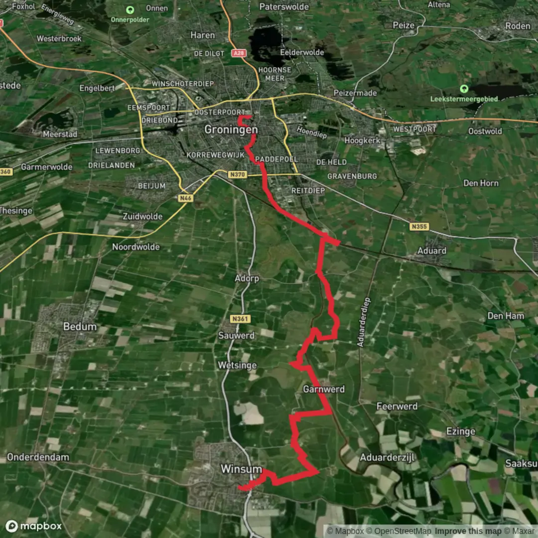
22.2 km
~4 hrs 26 min
0 m
Point-to-Point
“From Winsum’s quiet canals and wide skies to Groningen’s streets, a flat, wind-shaped journey.”
This easy, mostly level point-to-point walk runs from the village of Winsum down into the city of Groningen, finishing at Groningen Hoofdstation (Groningen Central Station). Expect a classic northern Netherlands landscape: wide skies, canals and drainage ditches, pastureland, and long straight paths that make the distance feel very manageable—until the wind reminds you how open the terrain is.
- Distance: ~22 km / ~13.7 miles
- Elevation gain: ~0 m / ~0 ft (bridges and embankments create only tiny, short rises)
- Time planning: many hikers budget 4.5–6 hours depending on pace, stops, and wind
- Difficulty: Easy (navigation and footing are generally straightforward; exposure to weather is the main challenge)
Getting to the start (Winsum) and end (Groningen Hoofdstation)
Start landmark: plan to begin near Winsum railway station (Station Winsum), a convenient and recognizable meeting point close to the village center.
- By public transport: Winsum is served by regional trains and buses in Groningen province. A common approach is to travel to Groningen first, then take a short regional train ride north to Winsum.
- By car: Winsum is reachable via local roads connecting to the Groningen ring-road network. Parking is typically easiest near the station area or village-center public parking (check local signage for time limits).
- Finish logistics: the route ends at Groningen Hoofdstation, which is ideal for onward trains/buses and has services nearby (shops, cafés, restrooms in/around the station).
If you’re using a navigation app, load the route in HiiKER before you set off; in flat farmland, paths can look similar and small turns are easy to miss.
What the route feels like underfoot
From Winsum, the walk quickly settles into quiet rural corridors—farm tracks, paved cycle paths, and compacted gravel alongside waterways. Surfaces are usually firm and fast, with occasional muddy edges after rain where tractors have churned the verge. Because the region is engineered for water management, you’ll cross or parallel ditches, canals, and small sluices; these are scenic but can be slippery at the margins, especially in winter or after storms.
Wind exposure is the defining “terrain feature.” With few hills and long sightlines, a headwind can add noticeable effort even though the elevation gain is essentially zero.
Route breakdown with approximate distances
0–5 km / 0–3.1 mi: Winsum outskirts to open fields
Leaving the station area, you’ll transition from village streets to open countryside. Look for classic Groningen province details: tidy farmyards, straight drainage lines, and occasional stands of trees acting as windbreaks. This early section is a good place to settle into a steady pace and check that your layers are right—once you’re out in the open, stopping to adjust clothing can feel chilly.
5–12 km / 3.1–7.5 mi: Canal-side walking and long rural straights
The middle portion tends to be the most “linear”: long, flat stretches beside watercourses and across agricultural land. Expect:
- Birdlife: herons, gulls, and seasonal flocks of geese; in wetter margins you may spot ducks and waders.
- Livestock: cattle and sheep are common; keep dogs leashed and give animals space at gates and narrow paths.
- Water edges: many banks are steep-sided; stay on the path rather than the grassy lip, which can collapse or be slick.
This is also where navigation discipline matters most. In a grid of paths and dikes, it’s easy to follow the “obvious” straight line that isn’t actually your route—use HiiKER to confirm junctions.
12–18 km / 7.5–11.2 mi: Approaching Groningen’s northern edge
You’ll begin to notice more infrastructure: busier cycle routes, more frequent bridges, and the first suburban edges. The landscape shifts from farm plots to mixed green corridors and built-up areas. Footing remains easy, but you’ll share space with cyclists—stay predictable, keep right where appropriate, and be especially careful when stepping aside near water or soft verges.
18–22 km / 11.2–13.7 mi: Into the city and to Groningen Hoofdstation
The final stretch becomes distinctly urban. You’ll likely pass parks, canals, and city streets as you thread toward the station. Wayfinding can actually feel trickier here than in the countryside because of intersections and one-way cycle lanes—again, HiiKER helps keep you on the cleanest line to the station entrance.
Landmarks, nature, and what to look out for
- Water management landscape: Groningen’s countryside is shaped by centuries of drainage, dikes, and canal engineering. The straight waterways and raised paths you’ll follow are part of a long tradition of keeping low-lying land productive and settlements safe.
- Wide-sky wildlife watching: open fields make it easy to scan for birds of prey and large flocks. Bring binoculars if you enjoy birding.
- Seasonal conditions:
- Autumn/winter: short daylight and strong winds; edges can be slick with leaf litter and algae on bridges.
- Spring/summer: more comfortable temperatures, but sun exposure can be high due to limited shade—pack sunscreen and water.
- Autumn/winter: short daylight and strong winds; edges can be slick with leaf litter and algae on bridges.
Practical planning: food, water, clothing, and safety
- Water & snacks: Winsum has village services, and Groningen has everything at the end, but the rural

Surfaces
Concrete
Unknown
Asphalt
Paved
Comments and Reviews
User comments, reviews and discussions about the Winsum to Hoofdstation via Selwerderhof, Netherlands.
average rating out of 5
0 rating(s)