Download
3D Flyover
Add to list
More
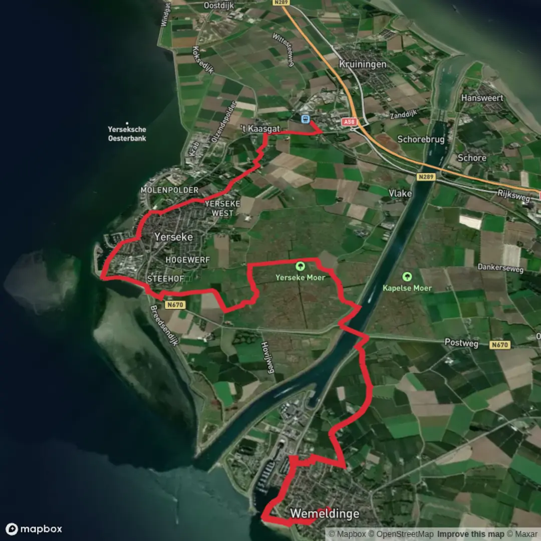
15.6 km
~3 hrs 7 min
0 m
Point-to-Point
“A breezy, sea-level Zeeland ramble of big skies, tidal flats, and quiet polder lanes.”
This is a flat, sea-level walk of about 16 km / 10 miles with essentially 0 m / 0 ft of elevation gain, linking two classic Zeeland landscapes: a tidy dike-top coastline on the Oosterschelde (Eastern Scheldt) and the low, reclaimed polders and creeks inland around De Breede. Underfoot is mostly firm: paved village streets, compacted gravel, and long stretches of dike path—ideal for an easy day, but very exposed to wind.
Getting to the start (Wemeldinge)
Best start landmark: the waterfront by Jachthaven Wemeldinge (Wemeldinge Marina), Sluisplateau 29, 4424 BK Wemeldinge. (debloesemvanzeeland.nl)
That marina area is a practical “trailhead” because it’s easy to find, has clear access to the sea dike, and you’re immediately in the open Oosterschelde landscape.
By car: Drive to Wemeldinge and park near the marina/Sluisplateau area (look for signed marina parking). From there you can step straight onto the dike routes.
By public transport: Wemeldinge is served by buses; a common village stop is Wemeldinge, Dorpsplein (the central square stop). (drgl.nl)
From Dorpsplein it’s a short walk to the waterfront and the dike.
Getting back from the finish (Kruiningen / Yerseke side)
A convenient end-point for public transport is Station Kruiningen–Yerseke, Stationsweg 23, 4416 PH Kruiningen, which has a large P+R and rail connections. (vertrekinfo.nl)
Buses also call here (including lines that connect toward Wemeldinge on weekdays). (en.wikipedia.org)
You’ll want to have HiiKER loaded before you start, because the dike network and farm lanes can present multiple “almost-parallel” options—easy terrain, but easy to drift onto the wrong spur if you’re not checking junctions.
The walk: what to expect, section by section
0–3 km (0–1.9 mi): Wemeldinge waterfront and onto the Oosterschelde dike
Starting near the marina, the route quickly becomes about big skies and salt air. The Oosterschelde is a tidal estuary, so the view changes hour by hour: at high tide it’s open water; at low tide you’ll often see exposed mudflats and sandbanks.
Conditions to plan for - Wind exposure: there’s very little shelter on the dike. Even on mild days, windchill can feel sharp. - Sun exposure: bring sunscreen and a brimmed hat in warmer months—shade is scarce.
Wildlife watch From the shore around Wemeldinge, seals can sometimes be spotted with patience and binoculars, especially around low tide when they haul out on sandbanks. (np-oosterschelde.nl)
3–8 km (1.9–5 mi): Long dike miles—tidal flats, birds, and “working water”
This is the most “Zeeland” feeling part: straight, steady dike walking with wide views over the Oosterschelde. The estuary is internationally important for coastal birds because the tidal flats are rich feeding grounds (worms, crabs, shellfish). Rijkswaterstaat monitoring on sandbanks like the Roggenplaat highlights how crucial these flats are for large numbers of waterbirds at low tide. (rijkswaterstaat.nl)
What to look for - Waders and waterfowl probing the mud at low tide. - Seals resting on distant banks (binoculars help). - In calm conditions, you may also see signs of porpoises (brief dorsal fin slices), which are known in the Oosterschelde.

Surfaces
Unknown
Asphalt
Grass
Unpaved
Concrete
Wood
Comments and Reviews
User comments, reviews and discussions about the Wemeldinge to Kruiningen Yerseke via De Breede and Oosterschelde, Netherlands.
average rating out of 5
0 rating(s)