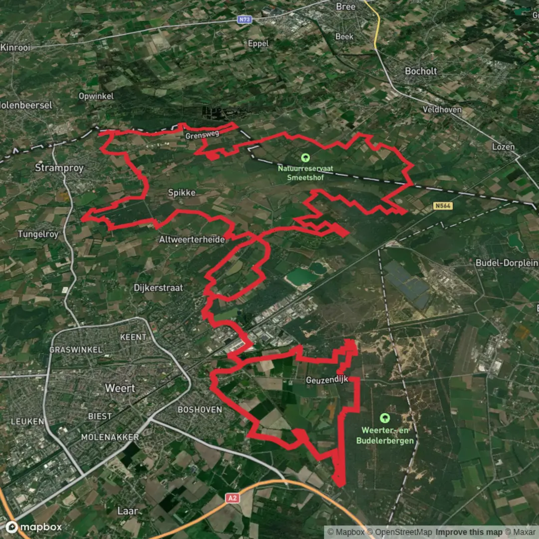
Grote Ijzeren Man, Tungelerwallen, Stramprooise Heide and Kruispeel en Achterbroek Knot
Download
3D Flyover
Add to list
More
62.5 km
~3 days
6 m
Multi-Day
“A meandering loop of lake, heath, pine and hushed border wetlands—best savoured with steady feet.”
This is a long, low-lying loop-style day hike (or relaxed 2-day outing) through a classic patchwork of South Netherlands landscapes: a large recreational lake and woodland edges, sandy heath and pine, long straight farm tracks, and some of the quietest wetland corners near the Belgian border. At around 62 km / 38.5 mi with roughly 0 m / 0 ft of climbing, the challenge is less about elevation and more about time on feet, foot comfort on mixed surfaces, and staying oriented through a dense network of paths.
Getting to the start (car + public transport)
Because the start point is listed only as “near” (no coordinates provided), the most practical and common trailhead for this route name is the Grote IJzeren Man recreation area in/near Weert (Limburg, Netherlands)—a well-known lake and park area used as a walking hub.
- By car: Aim for the Grote IJzeren Man / De IJzeren Man recreation area, Weert (look for parking signed for the lake/recreation grounds). Arrive early on weekends; this is a popular local destination and parking fills quickly in good weather.
- By public transport: The nearest major rail hub is typically Weert Station. From there, local buses and/or a short taxi ride can get you close to the lake area; if you prefer walking in, plan extra distance and time from the station to the recreation area.
If you share the start lon/lat, I can pin it to the nearest street address or landmark precisely and tailor the approach directions.
What the route feels like underfoot (and why “easy” still needs planning)
Even with minimal elevation change, 62 km / 38.5 mi is a big day. Expect a steady rotation of: - Firm cycle paths and compacted gravel (fast, but repetitive) - Forest tracks (often sandy in places—slower, more calf/ankle work) - Heathland paths (can be narrow, with soft edges) - Dike-top or drainage-canal tracks in the peat/wetland sections (straight, exposed to wind)
Plan for 10–14 hours moving time for most hikers depending on pace and breaks. Foot care matters: long flat routes can create hot spots because you repeat the same stride for hours.
Grote IJzeren Man → Tungelerwallen (approx. 0–18 km / 0–11 mi)
You’ll likely begin around the Grote IJzeren Man—a broad lake with a recreational feel, fringed by trees and paths that quickly let you settle into a rhythm. Early on, you’ll pass through woodland edges and managed green spaces before the route starts feeling more rural.
As you angle toward Tungelerwallen, the landscape becomes more open and agricultural, with straight tracks, hedgerows, and drainage ditches typical of this part of Limburg. Navigation is generally straightforward here, but there are many junctions where multiple tracks look similar—this is where having your route loaded in HiiKER helps prevent small wrong turns that can cost time later.
What to look out for: - Hard surfaces early can tempt a fast pace—save your legs for the later sandy/heath sections. - Wind exposure increases as you leave the lake/woodland shelter. - In wet periods, some field-edge paths can be muddy or slick, even though the region is flat.
Stramprooise Heide (approx. 18–38 km / 11–24 mi)
This is the section that most hikers remember: heathland and pine with a more “wild” feel than the farmland corridors. The ground can turn sandy, especially on well-used forest tracks, and your pace may drop without you noticing at first.
Nature and wildlife: - Heath and mixed woodland can host roe deer, and you may spot buzzards and kestrels hunting over open patches. - In warmer months, expect insects (especially near wetter edges); in tick season, do a quick check after passing through taller grasses and heather margins. - The heathland ecology is shaped by long-term land use—historically, heaths in the Netherlands were often maintained by grazing and cutting; today many areas are actively managed to prevent them from turning entirely into forest.
Practical notes: - Shade comes and goes; on sunny days this middle stretch can feel surprisingly warm. - Sandy segments can work grit into shoes—consider gaiters if you’re prone to sand irritation.
Kruispeel & Achterbroek (approx. 38–62 km / 24–38.5 mi)
The final third trends into quieter, more water-influenced terrain—peaty wetlands, reedbeds, drainage channels, and flat tracks that can feel very remote despite being in a densely managed country. “Peel” landscapes are strongly associated with historic peat extraction across the broader region (the Peel area spans parts of Limburg and North Brabant). Even where extraction has ended, the legacy remains in the straight canals/ditches, reclaimed parcels, and wetland restoration zones.
Expect: - Long straight lines (can be mentally tiring late in the day) - Damp ground near ditches and low spots; after rain, some paths may have puddles that force detours along the verge - Big skies and open views—beautiful, but more exposed if weather turns
Wildlife highlights often include: - Waterfowl (ducks, geese) and wetland songbirds - Occasional herons along ditches and pools
Late-route hazards:

Surfaces
Unknown
Ground
Sand
Asphalt
Gravel
Unpaved
Dirt
Concrete
Paved
Comments and Reviews
User comments, reviews and discussions about the Grote Ijzeren Man, Tungelerwallen, Stramprooise Heide and Kruispeel en Achterbroek Knot, Netherlands.
average rating out of 5
0 rating(s)