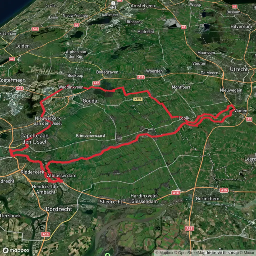
Reeuwijkse Plassen and Nieuwpoort via Zwarteweg, Baarsjeskade, Damweg and De Hetting
Download
3D Flyover
Add to list
More
127.4 km
~5 days
27 m
Multi-Day
“A long, flat ribbon of water and wind—reedbeds, dikes, and polder horizons to Nieuwpoort.”
This is a long, flat, water-shaped trek through the Green Heart of the Netherlands: peat lakes, reedbeds, canal banks, dikes, and wide polder horizons, linking the Reeuwijkse Plassen lake district with the Lek River landscape and the fortified town of Nieuwpoort. At around 127 km (79 mi) with roughly 0 m (0 ft) of climbing, the effort is less about elevation and more about surface variety, wind exposure, and staying comfortable for many hours on open dikes.
Because your “Hike head” and hike type aren’t specified, plan this as either:
- a 2–4 day point-to-point (most common for 127 km / 79 mi), or
- a fast 1–2 day push if you’re used to long, flat distances.
For navigation, load the full line in HiiKER and keep an eye on the many junctions where dike paths, farm tracks, and canal-side lanes intersect.
Getting to the start (public transport + car)
This route name references Zwarteweg in the Reeuwijk/Reeuwijk-Brug area (South Holland), so the most practical approach is to start near Reeuwijk-Brug / Gouda and finish near Nieuwpoort (Molenlanden) on the Lek.
By public transport (typical approach): - Take the train to Gouda (major rail hub), then a local bus toward Reeuwijk / Reeuwijk-Brug. From there it’s usually a short walk to the Zwarteweg-area lanes that lead into the plassen (lakes). - For the finish, Nieuwpoort (South Holland) is served by regional buses via nearby towns in the Alblasserwaard/Lek corridor; you’ll typically connect through larger nodes such as Gorinchem or Schoonhoven depending on the line.
By car: - Park near Reeuwijk-Brug (look for public parking around village centers and lake access points), then arrange a pickup at Nieuwpoort or use two cars. In peak warm-weather weekends, lake-area parking can fill early.
If you share the route’s start coordinates (lon/lat), I can pin it to the nearest specific landmark/address; with the current info, the best “nearest known” anchor is Reeuwijk-Brug / Reeuwijkse Plassen access area. (en.wikipedia.org)
What the walking is like (surfaces, pacing, and exposure)
Expect long stretches of:
- Dike-top paths (often paved or compacted),
- Canal-side lanes (quiet asphalt),
- Farm tracks (can be muddy after rain), and
- Narrow embankments where you’ll want steady footing.
Even with “0 m” of gain, you’ll feel the day because: - Wind off open water and across polders can be relentless. - Hard surfaces dominate; cushioned footwear and blister management matter more than ankle support. - Limited shade is common—sun and glare off water can be surprisingly tiring.
A realistic all-day pace for many hikers on flat Dutch terrain is 4–5 km/h (2.5–3.1 mph) moving speed, but plan extra time for gates, photos, food stops, and navigation checks.
Reeuwijkse Plassen: lakes, reedbeds, and birdlife (first major section)
The Reeuwijkse Plassen are a classic lowland lake landscape—broad water, reed fringes, and long sightlines. You’ll often be walking with water on one side and polder fields on the other, with frequent small bridges and side channels.
Nature & wildlife to look for - Waterfowl and marsh birds are the headline here: ducks, geese, grebes, coots, and seasonal migrants. Reedbeds can also hold smaller songbirds, though they’re easier to hear than see. - In warmer months, insects can be intense near still water—pack repellent and consider long sleeves if you’re sensitive.
Key things to watch out for - Narrow edges on some embankments: give cyclists space where paths are shared. - Slippery algae on waterside concrete/wood near locks and small landings. - Sudden weather shifts: open water means you’ll notice wind and squalls quickly.
Along Zwarteweg, Baarsjeskade, Damweg, and De Hetting: the “quiet lanes” backbone
The named roads in your title suggest a route stitched together from local dike roads and canal-side kades (quays/embankments). These are typically low

Surfaces
Asphalt
Unknown
Concrete
Grass
Wood
Paved
Unpaved
Comments and Reviews
User comments, reviews and discussions about the Reeuwijkse Plassen and Nieuwpoort via Zwarteweg, Baarsjeskade, Damweg and De Hetting, Netherlands.
average rating out of 5
0 rating(s)