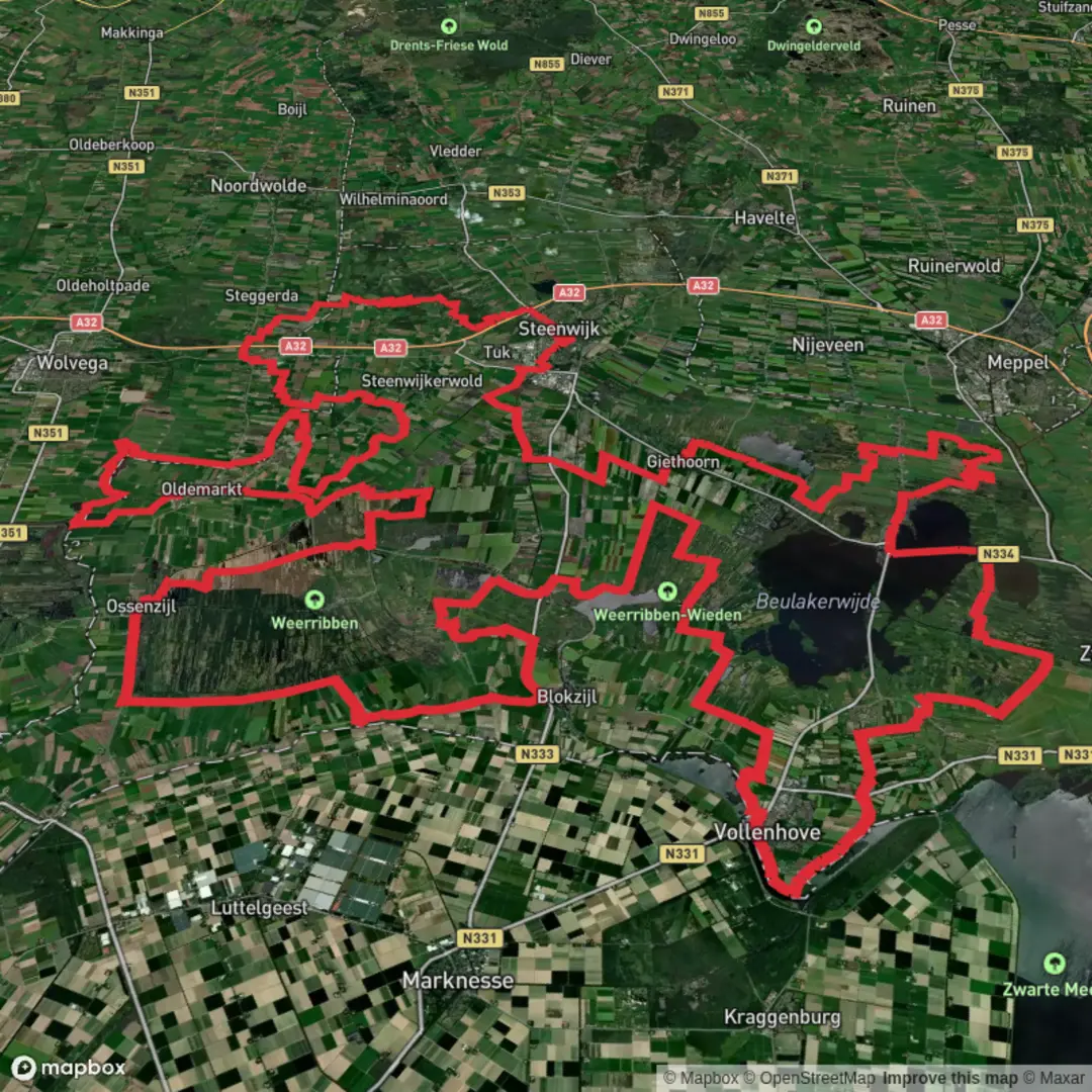
Bentendijkpad, Blauwehandseweg, Eesveenseweg and Overlendepad Loop
Download
3D Flyover
Add to list
More
156.1 km
~6 days
109 m
Multi-Day
“A big-sky borderlands loop of farm lanes, reed-fringed waters, and dead-straight dikes—flat, wind-tested, and quietly demanding.”
This is a big, lowland loop through the borderlands of Overijssel and Flevoland, linking quiet farm lanes (Eesveenseweg/Overlendepad), peat-and-reed waterscapes around the Kop van Overijssel, and long, ruler-straight dike and polder corridors where names like Bentendijkpad make sense: you’re often walking on engineered embankments that keep reclaimed land dry. At roughly 156 km / 97 mi with only about 100 m / 330 ft of total ascent, the challenge is almost never steepness—it’s time on feet, wind exposure, and surface variety.
A practical “hike head” for planning is the Eesveen / De Eese area, just southeast of Steenwijk. A reliable landmark to aim for is Landgoed De Eese (near Eesveen), a well-known estate landscape on the edge of the Woldberg ridge. (deeese.nl)
Getting to the start (car + public transport)
- By train: Use Steenwijk railway station as the main rail hub; it’s on the NS intercity line between Zwolle and Leeuwarden. (en.wikipedia.org)
- By bus: From the Steenwijk station area, regional buses run toward the countryside villages; Eesveen is served by services that include stops such as “Eesveen, De Eese” on the corridor between Heerenveen and Steenwijk (service patterns vary by day/time). Check the current timetable before committing to a start time. (wiki.ovinnederland.nl)
- By car: Navigate to the Eesveen side of the route via Eesveenseweg (Eesveen)—this road is the direct rural connector between Steenwijk and Eesveen. For a “nearest known address” anchor, Eesveenseweg, 8347 JE/JC, Eesveen is the correct corridor to target, then choose a safe, legal pull-in/parking spot near public access points (avoid blocking farm gates). (funda.nl)
For navigation, load the full loop into HiiKER and also save key “bail-out” points (Steenwijk, Wanneperveen/Belt-Schutsloot area, Emmeloord area) so you can shorten days if weather turns.
What the terrain feels like (and why it’s “easy” but not “casual”)
Expect a steady rotation of: - Asphalt farm lanes (fast, repetitive, hard on feet) - Dike-top paths and canal-side tracks (open, windy, big skies) - Shorter unpaved segments that can be slick after rain, especially where paths run beside reedbeds and drainage ditches
Because the elevation gain is tiny (~100 m / 330 ft total), pacing is straightforward—until wind and exposure slow you down. In this part of the Netherlands,

Surfaces
Asphalt
Unknown
Concrete
Grass
Sand
Ground
Gravel
Wood
Paved
Dirt
Comments and Reviews
User comments, reviews and discussions about the Bentendijkpad, Blauwehandseweg, Eesveenseweg and Overlendepad Loop, Netherlands.
average rating out of 5
0 rating(s)