Download
3D Flyover
Add to list
More
18.7 km
~3 hrs 44 min
0 m
Point-to-Point
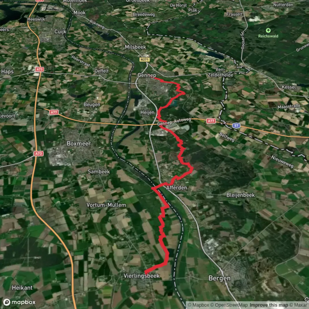
“A gentle, flat meander from Heijen’s church through sandy pinewoods to the reedy Niers near Gennep.”
This is a flat, lowland walk through the northern Limburg border landscape: quiet pine-and-oak woodland, sandy tracks, and then the open, reedier feel of the Niers valley as you approach the bridge area near Gennep. At around 19 km / 11.8 mi with roughly 0 m / 0 ft of climbing, it’s more about steady pacing, footing on mixed surfaces, and staying oriented through a web of forest paths than about elevation.
Getting to the start (and where “Kerk” usually means)
“Kerk” in this area typically refers to the church in/near Heijen (Limburg, NL)—a practical, recognizable meeting point in the village core. If you’re arriving by car, aim for parking near the village center around the church (look for signed public parking by the main streets in Heijen). If you’re using public transport, the most straightforward approach is usually: - Train to Gennep or Boxmeer, then a regional bus/taxi onward to Heijen village center (services vary by day/time). Because rural bus timetables can change seasonally, it’s worth checking the current connections the day before you go.
For the finish, “Niersbrug” is best understood as the bridge area over/along the River Niers at Gennep—a well-known landmark tied to both older crossings and WWII history (more on that below). (liberationroute.com)
What the route feels like underfoot
Expect a mix of village pavements, hard-packed forest tracks, and sandy stretches where the path crosses drier heath/duin (dune) soils. After rain, the Quin area can feel damper underfoot in places (pond-and-wetland influence), while the conifer sections of the Heijense Bossen tend to drain quickly but can hide soft sand that slows your pace.
Because the terrain is so flat, the main “effort spikes” come from: - Loose sand (especially if you’re in lighter, dune-like soils) - Long straight forest lanes (mentally monotonous for some hikers) - Navigation at junction-dense sections (many similar-looking tracks)
If you’re using a navigation app, keep it to HiiKER and zoom in at every multi-track junction—this region has lots of parallel forestry roads that can lure you off-route without you noticing until the next crossing.
From the church area into the Quin (approx. 0–6 km / 0–3.7 mi)
The first few kilometres ease you out of the village and into a greener, quieter corridor. As you enter the Quin nature reserve, the character shifts: this is known for a vennencomplex—a cluster of small ponds/wet hollows—sheltered by higher, wind-shaped dune ridges. (voetstappen.nl)
What to look for here: - Still water and reedier edges in the hollows - Heathland hints where the soil turns sandy and nutrient-poor - Birdlife that favors wet pockets (listen for calls around the ponds)
Even on an “easy” route, this is a good place to slow down: narrow side paths and wildlife-view temptations can add distance if you wander.
Through Heijense Bossen (approx. 6–15 km / 3.7–9.3 mi)
After the Quin, the walk settles into longer woodland miles. The Heijense Bossen are classic Dutch managed forest: a blend of conifers and mixed woodland, with wide tracks that make for efficient walking. On some lines you may pass near holiday parks (often visible or signed but not necessarily entered), which can be a useful “you’re on track” confirmation when matching your position in HiiKER. (voetstappen.nl)
Key practical notes in this middle section: - Footing: alternating firm gravel/packed earth and occasional sand - Wayfinding: frequent intersections—confirm direction at each major crossing rather than “following the nicest track” - Wind exposure: generally sheltered in the forest, but openings can feel surprisingly breezy
Wildlife is typically subtle rather than dramatic—think woodland birds, small mammals, and the usual signs of deer in quieter stretches (tracks, browsing). Keep voices low if you want the best chance of spotting movement at the edges of clearings.
Dropping toward the Niers valley and Niersbrug (approx. 15–19 km / 9.3–11.8 mi)
As you leave the drier forest landscape, the route trends toward the Niers—a river that ultimately meets the Maas near the Dutch border area. The Niers is about 114 km / 71 mi long overall, with only a short stretch navigable in the Netherlands, and it’s well known locally for gentle current and a meandering valley feel. (kanoroutes.nl)
The approach to Niersbrug feels more open and “riverine” than the forest miles: expect softer ground

Surfaces
Unknown
Asphalt
Unpaved
Ground
Gravel
Sand
Paved
Comments and Reviews
User comments, reviews and discussions about the Kerk to Niersbrug via Quin and Heijense Bossen, Netherlands.
average rating out of 5
0 rating(s)