Download
3D Flyover
Add to list
More
9.2 km
~1 hrs 51 min
15 m
Loop
“Wander the Geul valley’s quiet lanes between monastery courtyards and castle views, pausing often.”
A gentle countryside loop through South Limburg’s Geul valley, linking two standout heritage sites—Kasteel Geulzicht and the monastery complex at Sint Gerlach—on mostly flat terrain. At ~9 km (5.6 mi) with roughly 0 m (0 ft) of climbing, it’s well-suited to a relaxed half-day walk, with frequent chances to pause for architecture, river scenery, and café stops.
Getting to the start (car + public transport)
Because the start point is listed only as “near” (no coordinates or place name), the most practical assumption for this loop is a start in Valkenburg aan de Geul, close to the Sint Gerlach area in Houthem-St. Gerlach (a common access point for these landmarks).
- By train: Take the train to Valkenburg station (Valkenburg aan de Geul). From there, you can walk or take a short local bus/taxi toward Houthem-St. Gerlach / Sint Gerlach to begin the loop near the monastery complex.
- By bus: Regional buses connect Maastricht ↔ Valkenburg ↔ Houthem depending on the line and day; check current schedules and stops for “Houthem” / “St. Gerlach” and plan your approach walk.
- By car: Aim for parking near Sint Gerlach (Houthem-St. Gerlach) or in Valkenburg aan de Geul and walk to the trail. Parking availability can vary on weekends and during events, so arriving earlier helps.
If you share a lon/lat for the trailhead, I can pin it to the nearest street address or landmark precisely.
You’ll want HiiKER loaded before you set off—this area has a dense web of footpaths, farm tracks, and signed junctions where it’s easy to take a parallel path that “feels right” but drifts off the intended loop.
From the start near the Sint Gerlach complex, the walk typically eases you out through quiet lanes and footpaths into the open valley landscape. Expect a mix of: - Paved village edges (brief, low-traffic stretches) - Hard-packed farm tracks and grassy field margins - Occasional gates/stiles where paths cross pasture boundaries
Within the first 1–2 km (0.6–1.2 mi), you’ll likely be moving between manicured grounds and pastoral scenery—hedgerows, small orchards, and open meadows that are characteristic of South Limburg’s softer, rolling countryside (even when the elevation gain is effectively negligible on this particular loop).
Landmarks and historical context (mid-route highlights)
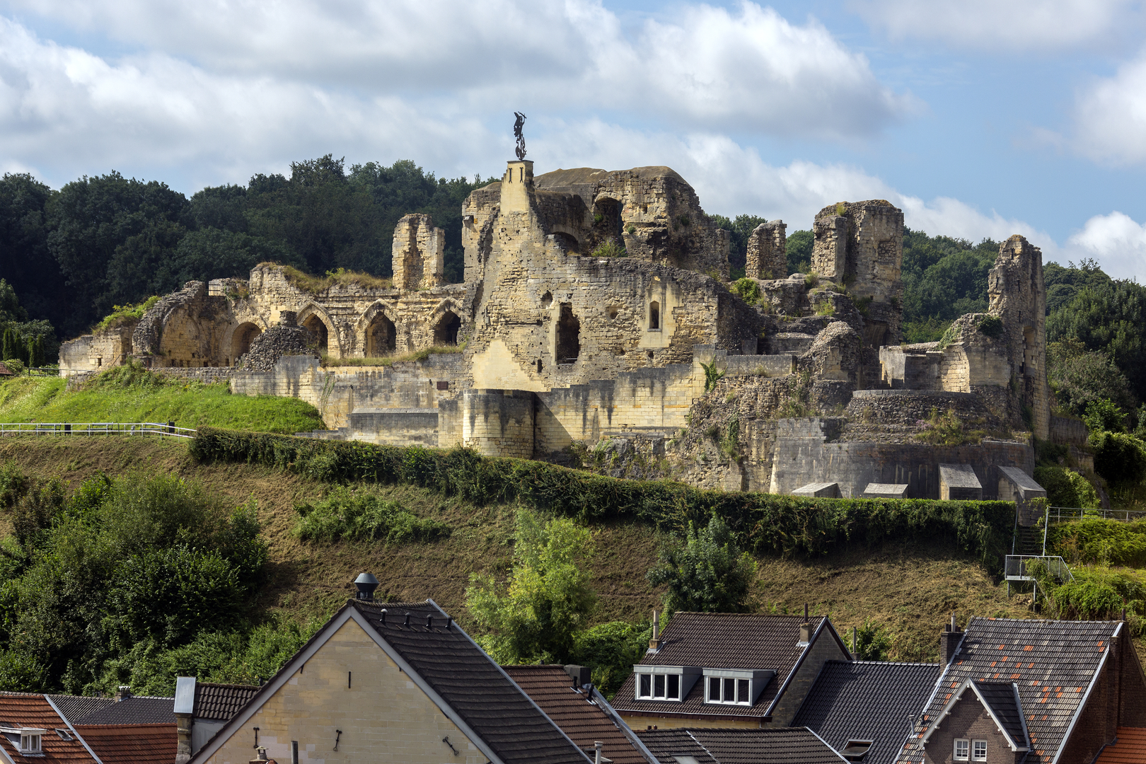
Sint Gerlach is one of the most significant cultural stops on the loop. The complex is known for its long religious history and distinctive architecture, and it anchors the route with a sense of place that’s very different from a purely “nature” walk. Even if you don’t go inside, the exterior views—courtyards, church elements, and surrounding grounds—are worth slowing down for.
As you continue (roughly 3–6 km / 1.9–3.7 mi into the loop, depending on the exact line you follow), the route swings toward Kasteel Geulzicht. “Kasteel” sites in this region often sit strategically near waterways and fertile land, reflecting centuries of land management, local power, and agricultural wealth. You may not always have full access to castle grounds (many are private or partially private), but the approach typically offers classic estate scenery: mature trees, long sightlines, and a shift from village textures to a more “parkland” feel.
Between these two heritage points, the Geul valley character comes through: lowland river corridor, damp meadows, and a patchwork of fields. Even on a flat route, you’ll notice subtle changes underfoot—slightly softer ground near wetter sections and firmer tracks on raised farm lanes.
Nature, wildlife, and what to look out for
This is a human-shaped landscape with plenty of life at the edges: - Birdlife: Expect common farmland and riparian birds—small songbirds in hedges, corvids over fields, and water-associated species closer to the Geul and drainage ditches. - Mammals: Rabbits and small mammals are typical; deer can appear at quieter times near wooded pockets and estate edges. - Plants: Hedgerows, meadow grasses, and seasonal wildflowers (especially in spring and early summer) are the main show. In wetter spots, look for more lush, moisture-loving vegetation.
Because the loop is low and near water-meadow terrain, it can feel surprisingly cool and damp compared with nearby higher ground. After rain, some field-edge paths can hold water or turn slick.
Underfoot conditions, accessibility, and pacing
- Surface: Mostly easy-going, but expect short muddy stretches after wet weather—especially where tractors have churned farm tracks or where paths run beside drainage lines.
- Elevation: About 0 m (0 ft) total gain as provided; any rises are likely gentle and brief.
- Time estimate: Many hikers will take 2–3 hours moving time for 9 km (5.6 mi), plus extra for stops at Sint Gerlach and viewpoints near the castle.
- Footwear: Light hiking shoes are usually enough in dry conditions; after rain, choose something with better grip and some water resistance.
Practical cautions (small things that matter)
- Farm traffic: Even on “quiet” tracks, you can meet tractors—step aside early and give them room, especially on narrow lanes.
- Livestock: If the route crosses pasture, keep distance from

Surfaces
Unknown
Asphalt
Grass
Gravel
Dirt
Sand
Cobblestone
Concrete
Unpaved
Paved
Wood
Comments and Reviews
User comments, reviews and discussions about the Kasteel Geulzich and Sint Gerlach Loop, Netherlands.
average rating out of 5
0 rating(s)