Download
3D Flyover
Add to list
More
20.0 km
~4 hrs
6 m
Loop
“A gentle loop weaving pine-scented dunes, hushed heath and lake-shimmering paths, with occasional soft sand.”
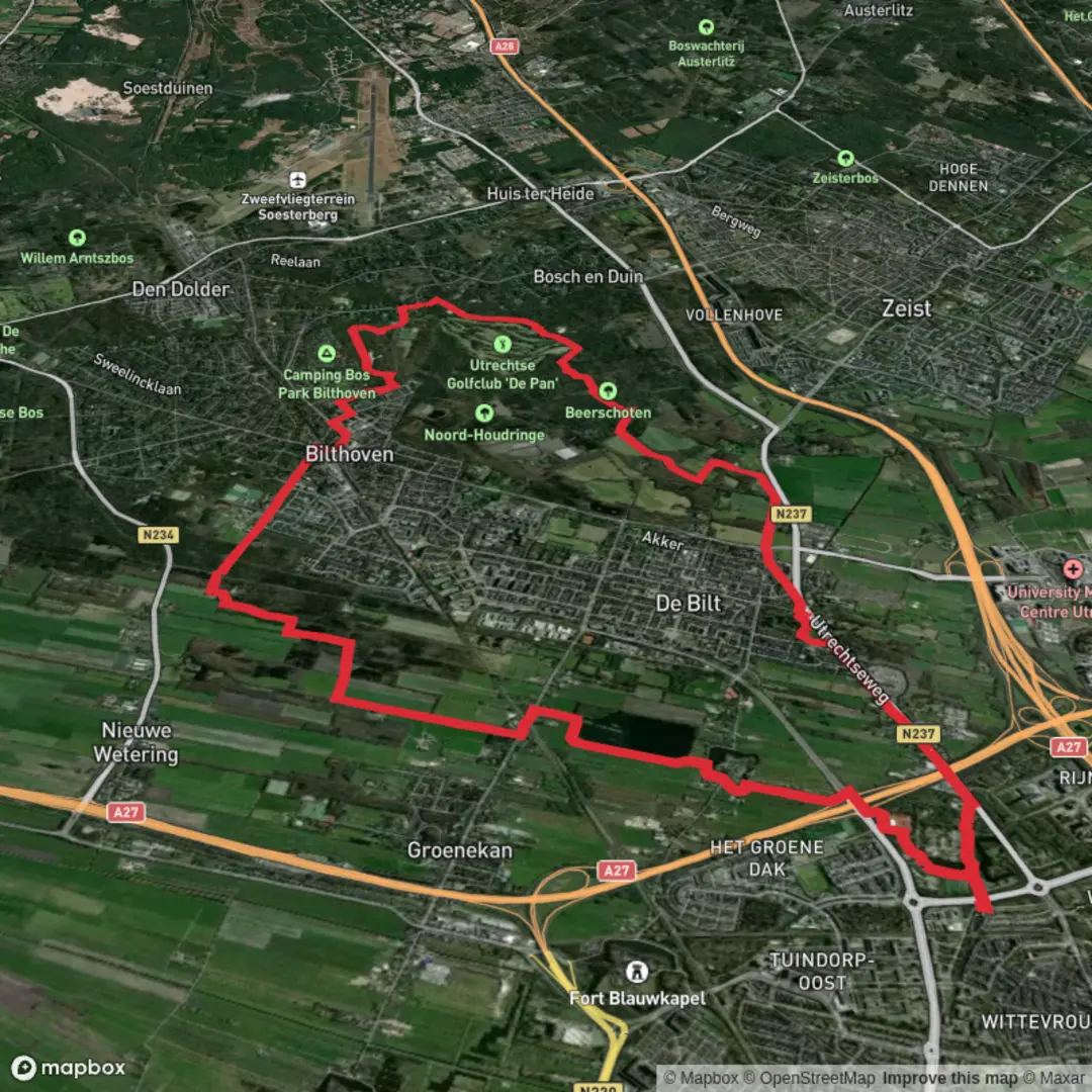
This easy, mostly flat loop of roughly 20 km (12.4 mi) with about 0 m (0 ft) of climbing is all about variety: sandy pine dunes, quiet heath and woodland edges, and a string of small lakes and plas (ponds) that attract waterbirds. Expect well-made paths and forest tracks with a few short sandy stretches where footing gets softer and pace slows.
Getting to the start (and where “near” usually means here)
Because the start point is listed only as “near,” the most practical assumption for this loop is that it begins around the Bilthoven / De Bilt side of the Utrechtse Heuvelrug—close to the dune and woodland complexes commonly referred to as Biltse Duinen and the nearby lake areas (De Leijen / Hooge Kampse Plas). A reliable “meet-up” landmark that’s commonly used for this area is Bilthoven railway station (Station Bilthoven), which sits on the edge of the forested zone and is a straightforward access point for a loop that threads dunes and plas areas.
- By public transport: Take the train to Station Bilthoven (frequent service from Utrecht and Amersfoort). From the station area, you can walk into the forest edge and connect to the loop using HiiKER to pick up the correct trail lines and junctions.
- By car: Aim for parking near the forest access points around Bilthoven / De Bilt (signed trailhead-style pull-ins and small lots are common around the woodland edges). Use HiiKER to select the closest parking to the loop’s start line and to confirm any access restrictions.
If you share the route’s coordinates (or a GPX), I can pin the start to the nearest specific street address or named car park and describe the first 1–2 km turn-by-turn more precisely.
You’ll typically begin on firm forest paths that quickly transition into the Biltse Duinen character: sandy, pine-scented, and open in places where wind and historic land use kept the dunes active. The first 3–5 km (1.9–3.1 mi) often feel the most “dune-like,” with: - Soft sand patches that can be surprisingly energy-sapping even on an “easy” profile. - Pine and mixed woodland offering shelter from wind. - Occasional open clearings where you’ll notice the ground cover shift to heather and hardy grasses.
Footing is the main “difficulty” here: not steepness, but the way sand can roll underfoot. Lightweight trail shoes are fine in dry conditions; after rain, sandy sections can firm up while low-lying forest tracks may hold shallow puddles.
Lakes, plas edges, and wildlife watching
As the loop swings toward De Leijen and Hooge Kampse Plas, the feel changes from dune-walk to waterside ramble. Over roughly 6–10 km (3.7–6.2 mi) of the middle portion, you’ll likely alternate between: - Woodland tracks (wide, easy walking) - Narrower paths near water margins - Short connectors between lakes/ponds
These plas areas are excellent for quiet wildlife spotting. Depending on season and time of day, look for: - Waterfowl (ducks, geese, coots) and occasional grebes - Songbirds in the reedier edges and scrub - Roe deer at woodland margins, especially early/late - In warmer months, dragonflies and other insects around still water
Keep an eye out for subtle path splits near the water: informal “fisher paths” can tempt you off-route. This is where HiiKER is most useful—confirm you’re staying on the intended loop rather than drifting onto a dead-end shoreline track.
Panbos and the quieter forest stretches
The Panbos section tends to feel more enclosed and calm—less open sand, more consistent forest walking. This is where you’ll make up distance efficiently: steady pace, minimal elevation change, and fewer “energy tax” sandy steps. Over the final 6–8 km (3.7–5.0 mi), expect long, straight-ish forest segments broken by junctions.
Because the elevation gain is essentially negligible, your planning is mostly about: - Time on feet: 20 km (12.4 mi) is still a solid half-day for many hikers. - Surface variety: sand + forest track + occasional muddy patches. - Navigation at junction density: multiple intersecting paths can make it easy to take a parallel track that “looks right.”
What to look out for (practical hazards and comfort)
- Soft sand fatigue: Even with “0 m gain,” sand can slow you down. Budget extra time if conditions are dry and loose.
- After-rain puddling: Flat forest tracks can hold water; waterproof socks or quick-drying footwear can be more comfortable than heavy boots.
- Cyclists on shared tracks: In Dutch forest areas, some wider tracks are multi-use. Walk predictably and keep right where appropriate.
- Ticks: Common in dune/forest mosaics, especially spring through autumn. Long socks and a post-hike tick check are sensible.
- Wind exposure in open dune clearings: It can feel cooler than expected outside the trees.
Landmarks and regional context (why this landscape looks the way it does)
This part of the Utrechtse Heuvelrug region is shaped by a mix of sandy soils, woodland management, and historic land use. The dune and heath character you’ll

Surfaces
Unknown
Asphalt
Dirt
Sand
Paved
Concrete
Comments and Reviews
User comments, reviews and discussions about the Panbos, Biltse Duinen, De Leijen and Hooge Kampse Plas Loop, Netherlands.
average rating out of 5
0 rating(s)