Download
3D Flyover
Add to list
More
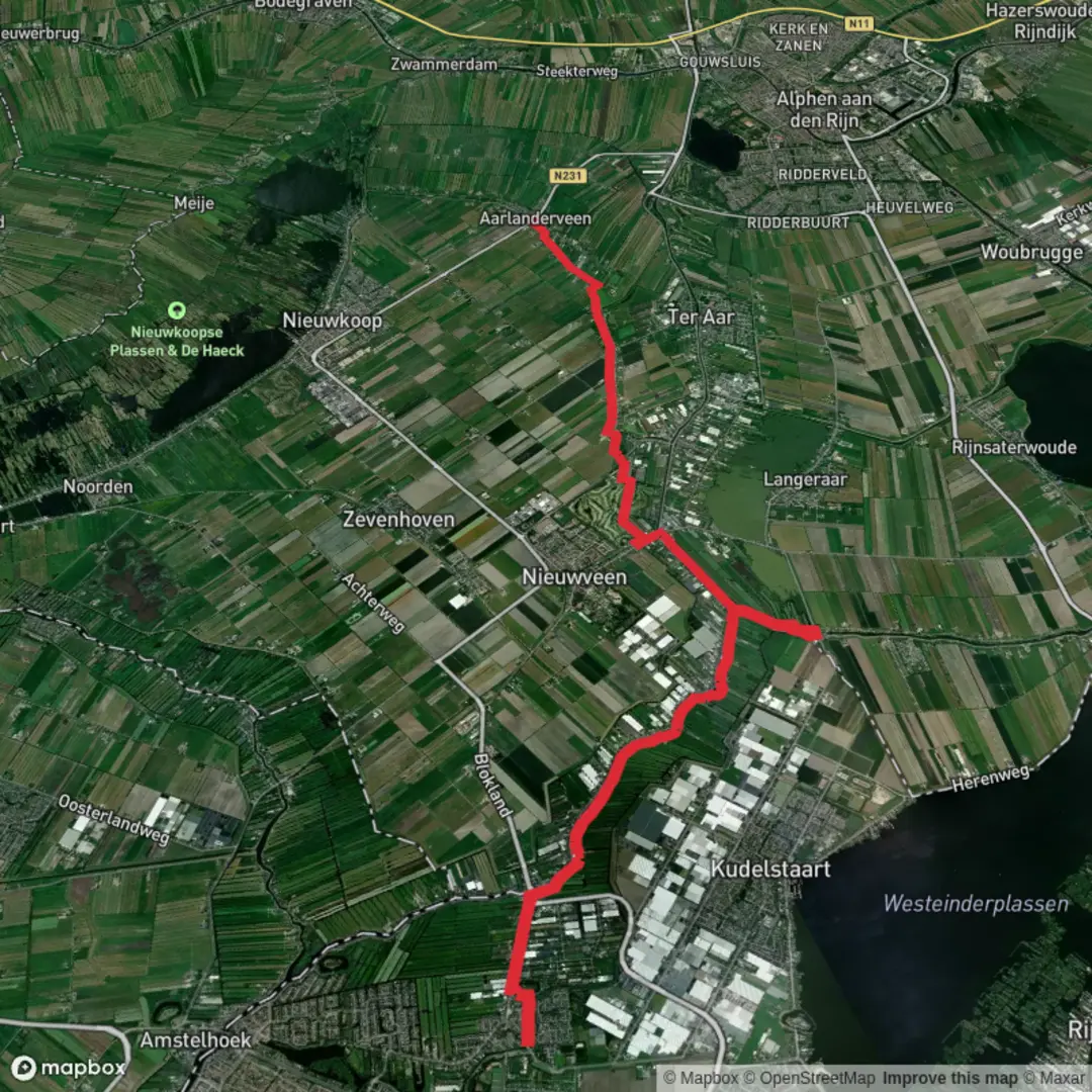
16.9 km
~3 hrs 23 min
0 m
Point-to-Point
“A big-sky polder ramble along dikes and canals—wind, waterfowl, and Dutch watercraft guiding you.”
This is a flat, water-shaped walk through the Dutch “Green Heart” landscape: long sightlines across reclaimed polders, narrow dikes between drainage canals, and small villages and farmsteads perched on slightly higher ground. At ~17 km (10.6 miles) with ~0 m (0 ft) of climbing, it’s best planned around wind exposure, path surfaces (often grassy or paved dike tops), and the fact that water and livestock fencing frequently dictate where you can and can’t cut across.
Getting to the start (De Kuil area)
By public transport: Aim for the nearest village hub with frequent buses/trains, then connect by local bus or a short taxi/bike hop to the “De Kuil” area. In this region, that typically means traveling via a larger rail station (often in the Alphen aan den Rijn / Woerden / Gouda orbit) and transferring to a local bus line serving the Nieuwkoop/Noorden/Zevenhoven countryside. Check the final stop and walking approach in HiiKER so you don’t end up on the wrong side of a canal with no crossing.
By car: Plan to park near a signed public access point (trailhead-style pull-off, small village parking area, or near a recreation access road) rather than on narrow farm lanes. Many polder roads are single-lane with soft verges and active agricultural traffic; keep wheels fully off the grass edges to avoid getting stuck and to keep access clear for tractors.
Start-point landmark guidance: “De Kuil” is commonly used locally for a small area/feature name rather than a single obvious street address. The most reliable way to pinpoint the start is to use HiiKER’s start marker and then match it to the nearest named road, bridge, or recreation access point (often a dike road or a small bridge over a drainage canal). If you share the start coordinates, I can translate them to the nearest recognizable road/bridge name.
What the route feels like underfoot (and why it’s so flat)
You’ll be walking through polder country—land reclaimed and managed by an intricate system of ditches, canals, pumps, and dikes. That’s why the elevation gain is effectively ~0 m (~0 ft): the terrain is engineered to be level, and the “ups and downs” are mostly just stepping onto dike crests, bridge ramps, and occasional raised farm tracks.
Expect a mix of:
- Paved or brick farm roads (easy, fast walking)
- Grassy dike-top paths (can be wet/soft after rain)
- Gravel or compacted tracks near field edges
Footwear: light hiking shoes are usually enough in dry spells; after rain, water-resistant shoes help because grass dikes can hold moisture and mud.
De Kuil to Kalslagerpolder (approx. 0–6 km / 0–3.7 miles)
The first third typically settles you into the rhythm of the landscape: straight lines, big skies, and water everywhere—ditches at your feet, wider canals to one side, and occasional reedbeds. You’ll likely pass: - Drainage canals and small bridges that act as natural “gates” between sections - Working pastureland with cattle and sheep (often behind electric fencing)
Because the route is so open, wind is the main “difficulty multiplier.” A calm day makes this feel like a gentle countryside stroll; a headwind can make 17 km (10.6 miles) feel much longer. Bring a wind layer even in mild temperatures.
Wildlife to watch for here often includes:
- Waterfowl (ducks, geese, swans) along wider channels
- Marsh and meadow birds around reed edges and wet fields
In spring and early summer, ground-nesting birds may be present in meadows; stay on the path and keep noise low near reedbeds.
Kalslagerpolder and Geerpolder: the heart of the walk (approx. 6–13 km / 3.7–8.1 miles)
This middle section is where the polder character becomes most obvious: long, ruler-straight drainage lines, fields divided by water, and dike roads that feel like causeways. The “landmarks” are often functional rather than monumental: - Pumping infrastructure (modern pump stations or older water-management structures) - Weirs, culverts, and sluice-like controls that regulate water levels - Reed fringes and wet corners where biodiversity concentrates
Water management & historical context
The broader Nieuwkoop area sits within the Netherlands’ long history of land reclamation and water control. Polders exist because communities organized to drain and maintain land that would otherwise be marsh or shallow lake. Over centuries, this evolved into formal water boards and sophisticated pumping systems. Even if you don’t pass a museum-style site, the entire route is effectively a living exhibit of Dutch hydraulic engineering: the straight ditches, the raised dikes, and the controlled water levels are the “story.”
What to look out for
- Narrow dikes with steep sides: Some dike tops are only a person or two wide, with a canal immediately beside you. In wet or windy conditions, give yourself extra space and slow down when passing others.
- Electric livestock fencing: Common along pasture edges. Gates may be spring-loaded or latch-based—leave them exactly as found.
- Limited shade: Sun and wind exposure are constant. In summer, bring sun protection and more water than you’d expect for a flat walk.
This is also the section where navigation can get subtly tricky: many tracks look similar, and canals force detours to the next bridge. Keep H

Surfaces
Unknown
Asphalt
Gravel
Comments and Reviews
User comments, reviews and discussions about the De kuil to Nieuwkoopseweg via Kalslagerpolder and Geerpolder, Netherlands.
average rating out of 5
0 rating(s)