Download
3D Flyover
Add to list
More
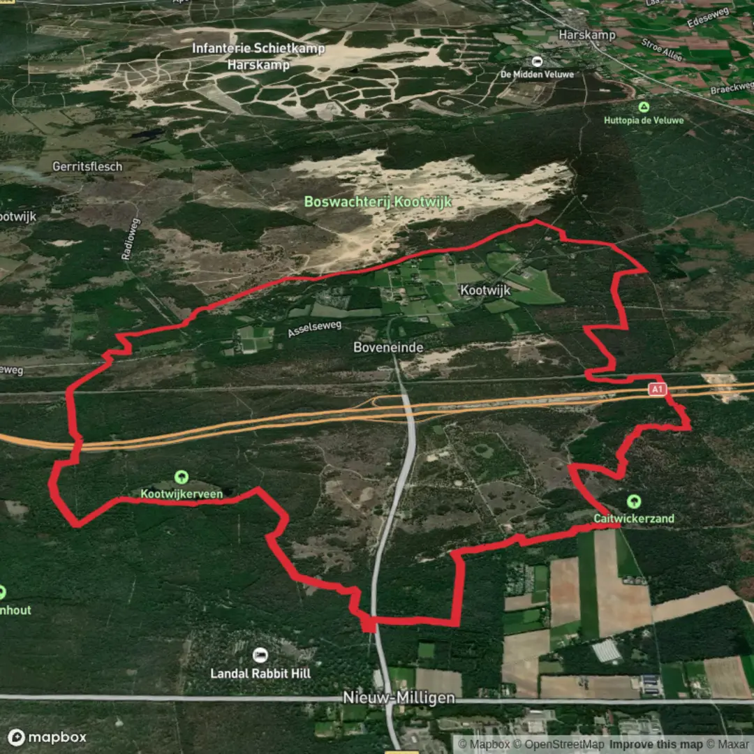
18.3 km
~3 hrs 42 min
25 m
Loop
“A mostly level Veluwe loop drifting from raised bog to heath and pine, with sand-softened strides.”
This easy, mostly level loop of about 18 km (11.2 mi) wanders through some of the Veluwe’s most distinctive landscapes: a rare patch of raised bog (Kootwijkerveen), open heath, dark pine plantations around Zanderdennen, and broad sandy tracks that feel almost coastal despite being inland. Expect long, gentle miles with minimal elevation change overall (roughly 0–50 m / 0–165 ft of small rollers depending on the exact line you follow), with the “effort” coming more from soft sand than from climbing. (staatsbosbeheer.nl)
Getting to the start (car + public transport)
Most common trailhead: Parkeerplaats Grevenhout, 3888 NR Uddel (Netherlands)—this is the signed start for the orange-marked route in the area. (staatsbosbeheer.nl)
- By car: Navigate to “Parkeerplaats Grevenhout, Uddel”. Arrive early on weekends/holidays; the Veluwe is popular and parking fills quickly on fair-weather days.
- By public transport: The nearest practical hubs are Apeldoorn and Barneveld/Harderwijk (depending on where you’re coming from), then a bus toward Uddel plus a walk/taxi to the Grevenhout parking area. Bus timetables and routing change seasonally, so check the current connections before you go.
For navigation on the ground, load the loop in HiiKER and keep it handy at junction-dense forest sections where sandy tracks braid and rejoin.
What the route feels like underfoot
From the Grevenhout trailhead you’ll quickly settle into the Veluwe’s classic mix of wide sandy forestry roads and narrower, winding paths. Much of the walking is unpaved, and after dry spells the sand can be loose—pace will naturally slow on the softest stretches. (staatsbosbeheer.nl)
The loop’s character changes in distinct “chapters”:
- Kootwijkerveen (raised bog and pools): You’re moving through an unusually wet pocket in an otherwise dry sandy region—look for peaty ground, small fens/ponds, and moisture-loving vegetation. Staatsbosbeheer notes recent nature restoration here (e.g., hydrology adjustments and habitat work) aimed at boosting biodiversity. (staatsbosbeheer.nl)
- Zanderdennen (pine woods): Expect straight trunks, filtered light, and a quieter feel under the canopy. In places the forest floor is needle-soft; elsewhere it’s sandy and open.
- Maanschoten area (heath/forest edges): This is where you often get the best sense of space—heathland margins and open corridors that can feel breezy and exposed compared with the woods.
Landmarks, nature, and wildlife to watch for
This loop is all about Veluwe ecosystems in close succession:
- Heath and juniper: The route is known for heathland and juniper patches—slow-growing, sculptural shrubs that thrive in these nutrient-poor sands. (staatsbosbeheer.nl)
- Old oaks and big conifers: You’ll pass sections described for rugged older oak woods and even stands of large Douglas-fir. (staatsbosbeheer.nl)
- Veluwe wildlife: The area is famous for “Veluws wild” (wildlife of the Veluwe). Dawn and dusk are prime times for sightings, but note that some segments in the wider region can have time-based access restrictions (often around sunset/sunrise), so confirm any local rules on your exact line in HiiKER before you set off late in the day. (komoot.com)
- Birdlife and insects: Restoration notes specifically mention improving conditions for species such as lizards, butterflies, and the European nightjar (nachtzwaluw), which favors open heath/woodland mosaics. (staatsbosbeheer.nl)
Distance markers (useful for pacing)
Because loops in this landscape can be braided with parallel sandy tracks, treat these as approximate: - 0–3 km (0–1.9 mi): Easy warm-up on sandy forest roads; good place to confirm your HiiKER track and settle into a steady pace. - 3–8 km (1.9–5.0 mi): Transition toward wetter ground and the Kootwijkerveen feel—more “fen and heath” character

Surfaces
Ground
Unknown
Sand
Dirt
Unpaved
Asphalt
Gravel
Comments and Reviews
User comments, reviews and discussions about the Kootwijkerveen, Zanderdennen and Maanschoten Loop, Netherlands.
average rating out of 5
0 rating(s)