Download
3D Flyover
Add to list
More
38.4 km
~2 days
92 m
Point-to-Point
“A long, flat countryside loop of sandy heath, farm lanes, and big skies—more endurance than climbs.”
This is a long, low-relief countryside loop of roughly 38 km (23.6 mi) with only about 100 m (330 ft) of total climbing, so the effort comes more from time-on-feet than steep gradients. Expect a mix of sandy tracks, farm lanes, heathland paths, and quiet rural roads, with big skies, open fields, and pockets of woodland and heather.
Getting to the start (car + public transport)
I’m missing the exact trailhead coordinates (“Hike head: near …” is incomplete). If you share the start lon/lat (or a map), I can pin it to the nearest address/landmark and tailor the directions precisely.
For planning right now: - By car: Most loops in the Manderheide/Hezingerveld area are typically started from a small parking area near the heath/forest edge or a village access point (common in this part of the eastern Netherlands). Aim to arrive early if you’re starting on a weekend, as small lots fill quickly. - By public transport: The usual pattern is train to a nearby regional station, then a local bus toward the closest village, finishing with a short walk to the trail access. Once you provide the start point, I’ll identify the best station/bus stop and the most straightforward approach on foot.
What the route feels like underfoot
Because the elevation gain is modest—about 100 m (330 ft) spread across the whole day—the loop is best thought of as a steady endurance walk. You’ll likely encounter: - Firm farm tracks and lanes (easy pacing, but exposed to wind) - Sandy or loose sections through heath/forest edges (slower, can be tiring late in the day) - Short grassy or heather-lined paths that can be wet after rain - Occasional paved connectors between landscape blocks
Even on an “Easy” profile, 38 km (23.6 mi) is a full-day outing for most hikers. Plan for 7–10 hours depending on breaks and surface conditions.
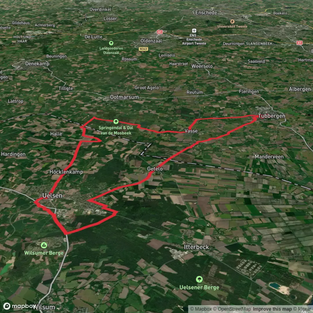
Route breakdown with landmarks and terrain (approximate)
0–8 km (0–5 mi): Settling into the countryside You’ll typically start with easy-going tracks leaving the village edge and moving into open agricultural land. These early kilometers are ideal for finding a sustainable pace. Look for field margins, drainage ditches, and hedgerows—these often hold small birds and provide the first hints of the heathland character ahead.
8–18 km (5–11 mi): Heathland and open nature blocks This is where the “heide” character usually becomes more obvious: broader views, lower vegetation, and a more natural feel than the farm lanes. In late summer, heather can color the landscape; outside that season, the same areas feel stark and spacious. Paths here can be sandy and may braid into multiple lines—use HiiKER to stay on the intended track where junctions are subtle.
18–28 km (11–17.4 mi): Hezingerveld sector—quiet, wide horizons Expect a calm middle section with long, straight stretches and gentle undulations rather than climbs. This is often the most mentally “big” part of the day: fewer obvious landmarks, more repetition, and exposure to weather. If there are benches, small shelters, or forest-edge clearings, they’re good places to schedule a longer break and foot check.
28–38 km (17.4–23.6 mi): Return leg—mixed surfaces back toward the start The final third commonly alternates between nature paths and rural connectors. Fatigue makes small surface changes feel bigger here: sand becomes more taxing, and hard pavement can feel harsh on feet. Keep an eye out for waymarks at the edges of fields and at T-junctions—this is where people most often drift off-route late in the day.
Navigation notes (keep it simple, keep it accurate)
This is the kind of landscape where you can be “almost right” for a long time—parallel tracks, similar-looking junctions, and long straight lines that make small errors costly in distance. Use HiiKER to: - Confirm you’re on the correct track when paths split in sandy/heath sections - Check upcoming junction density (helpful for timing breaks) - Avoid accidental detours onto private farm access roads
Nature and wildlife to look out for
Heathland and field-edge mosaics tend to support a lot of subtle wildlife rather than dramatic sightings: - Birdlife: small songbirds along hedgerows; open-country birds over fields; raptors sometimes circling on thermals in fair weather - Mammals: deer are possible near woodland edges (often early/late in the day); rabbits are common in sandy areas - Insects: in warmer months, expect plenty of pollinators around flowering heather and field margins
Ticks can be present in grassy/heath transitions—long socks and periodic checks are sensible, especially in warmer seasons.
Weather and exposure (what actually changes your day)
With so little climbing, the biggest variables are wind, rain, and underfoot softness: - Wind: open heath and farmland can feel significantly colder than the temperature suggests - Rain: sandy tracks can become heavy; grassy sections can turn slick; puddling can linger in low spots - Sun: long exposed stretches mean sun protection matters more than you’d expect on an “easy” hike
Practical planning: food, water, and timing
For 38 km (23.6 mi), plan like you would for a marathon-length walk: - Water: carry enough for long gaps between services;

Surfaces
Asphalt
Unknown
Concrete
Gravel
Unpaved
Ground
Sand
Paved
Cobblestone
Grass
Comments and Reviews
User comments, reviews and discussions about the Manderheide and Hezingerveld Loop, Netherlands.
average rating out of 5
0 rating(s)