Download
3D Flyover
Add to list
More
21.9 km
~4 hrs 23 min
0 m
Point-to-Point
“Wander from ancient monastery woods to sprawling peatlands on a peaceful, history-laced journey through Groningen’s tranquil borderlands.”
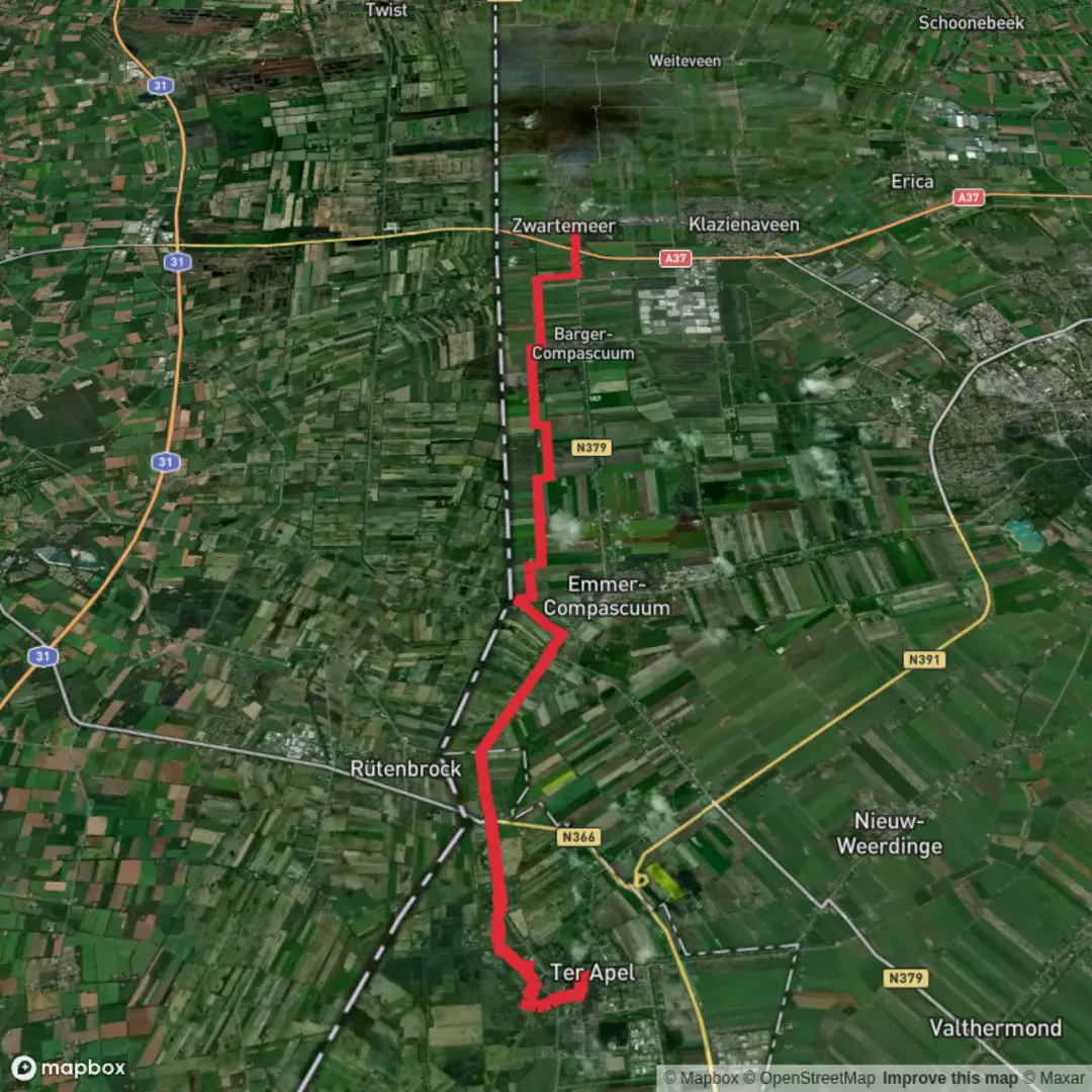
Starting from the historic village of Ter Apel, this 22 km (about 13.7 miles) route to Zwartemeer via Limiet Weg - Oost is a flat, easy walk through the tranquil landscapes of the Dutch province of Groningen, bordering Drenthe. With virtually no elevation gain, this trail is accessible for most walkers and ideal for those seeking a gentle, scenic day out.
Getting There
Ter Apel is well-connected by public transport. Buses run regularly from Emmen and Stadskanaal, stopping at Ter Apel’s central bus station, which is just a short walk from the trailhead near the Ter Apel Monastery (Klooster Ter Apel, Boslaan 3, 9561 LH Ter Apel). For those arriving by car, parking is available at the monastery or in the village center.
Trail Overview and Navigation
The route heads southeast from Ter Apel, following the Limiet Weg - Oost, a historic border path that once marked the boundary between Groningen and Drenthe. The trail is well-marked, but for precise navigation and up-to-date trail conditions, use HiiKER, which provides detailed maps and waypoints.
Landmarks and Points of Interest
- Ter Apel Monastery (Start, 0 km / 0 miles): The hike begins at the 13th-century monastery, a UNESCO-listed site surrounded by ancient woodland. Take time to explore the grounds before setting off.
- Ter Apeler Forests (0–5 km / 0–3.1 miles): The first section leads through dense mixed woodland, home to roe deer, foxes, and a variety of woodland birds. In spring and summer, the forest floor is carpeted with wildflowers.
- Limietweg Border Path (5–12 km / 3.1–7.5 miles): This stretch follows the historic Limietweg, once a customs route. Look for old boundary stones and information panels detailing the region’s shifting borders and smuggling history.
- Peatlands and Canals (12–18 km / 7.5–11.2 miles): The landscape opens up into wide peatlands and reclaimed agricultural fields. The route parallels several drainage canals, remnants of the area’s peat-cutting past. Waterfowl and marshland birds are common here, especially in spring and autumn.
- Zwartemeer Village (Finish, 22 km / 13.7 miles): The trail ends in Zwartemeer, a village known for its links to the peat industry and its proximity to the Bargerveen Nature Reserve. The village center offers cafés and bus connections to Emmen and other nearby towns.
Nature and Wildlife
Expect to see a mix of woodland and wetland habitats. The forests around Ter Apel are rich in birdlife, while the open peatlands attract herons, storks, and sometimes even cranes. The canals and ditches are home to frogs, dragonflies, and, in summer, clouds of butterflies.
Historical Significance
This region has a layered history, from medieval monastic life to centuries of border disputes and peat extraction. The Limietweg itself is a living reminder of the days when this was a frontier zone, and the landscape still bears traces of old customs posts and drainage works.
Trail Logistics
With a total distance of 22 km (13.7 miles) and no significant climbs, this route is suitable for most fitness levels. Surfaces are a mix of forest paths, gravel tracks, and quiet rural roads. There are several spots to rest or picnic, especially near the canals and in the villages at either end. Water and food are available in Ter Apel and Zwartemeer, but options are limited along the route, so plan accordingly.
For navigation, trail updates, and offline maps, HiiKER is recommended. The app provides reliable wayfinding and highlights points of interest along the way.

Surfaces
Unknown
Asphalt
Sand
Concrete
Unpaved
Gravel
Comments and Reviews
User comments, reviews and discussions about the Ter Apel to Zwartemeer via Limiet Weg - Oost, Netherlands.
average rating out of 5
0 rating(s)