Download
Preview
Add to list
More
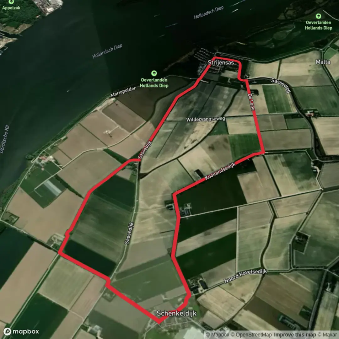
8.5 km
~1 hrs 42 min
0 m
Loop
“Big skies, shimmering water, and blooming wildflowers create a peaceful escape through Strijensas’ timeless landscape.”
Starting from the small village of Strijensas, located near the banks of the Hollands Diep in South Holland, this 9 km (about 5.6 miles) circular route offers a flat, easy walk with virtually no elevation gain, making it accessible for all levels of hikers. The trailhead is conveniently situated close to the Strijensas marina, a recognizable local landmark, and is easily reached by car via the N217, with parking available near the harbor. For those using public transport, buses from Dordrecht or Rotterdam connect to Strijen, from where a short taxi or bike ride brings you to Strijensas.
Navigating the Route
The path follows a mix of dike-top trails, quiet country lanes, and grassy embankments, all well-marked and easy to follow using HiiKER for navigation. The route loops through the scenic polders and along the water’s edge, providing expansive views over the Hollands Diep and the surrounding agricultural landscape. Expect to walk on a combination of paved and unpaved surfaces, with the occasional muddy patch after rain.
Nature and Wildlife
This region is known for its rich birdlife, especially in spring and autumn when migratory birds flock to the wetlands. Keep an eye out for herons, storks, and various species of ducks along the waterways. The polders are dotted with grazing sheep and cattle, and in summer, wildflowers line the dikes, attracting butterflies and bees. The tranquility of the area is only occasionally interrupted by passing boats on the river.
Historical Significance
Strijensas itself has a history tied to water management and trade. The village developed around a lock complex built in the 19th century, which played a crucial role in regulating water levels between the Hollands Diep and the inland polders. Remnants of these early engineering works can still be seen near the marina. The dikes you walk along are part of the extensive Dutch system of flood defenses, a testament to centuries of land reclamation and water control.
Points of Interest
At roughly the halfway point, the route passes close to the Strijensas Lock, where you can observe the lock gates and the old lock keeper’s house. The marina area offers a pleasant spot to rest, with benches overlooking the water and occasional food trucks or a small café open in the warmer months. The open fields and big skies make this a great walk for photography, especially at sunrise or sunset.
Preparation and Tips
Given the flat terrain and short distance, this hike is suitable for families and those looking for a leisurely day out. Sturdy walking shoes are recommended, especially after wet weather. There are limited facilities along the route, so bring water and snacks. The exposed dikes can be windy, so pack a windproof jacket even in summer. Dogs are allowed but should be kept on a leash, especially near livestock.
For navigation and up-to-date trail conditions, use HiiKER, which provides detailed maps and waypoints for the Strijensas Route.

Surfaces
Asphalt
Unknown
Grass
Paved
Comments and Reviews
User comments, reviews and discussions about the Strijensas Route, Netherlands.
average rating out of 5
0 rating(s)