Download
3D Flyover
Add to list
More
6.5 km
~1 hrs 18 min
0 m
Point-to-Point
“Drift from Hoberg’s quiet lanes past Oud Meer’s watery birdlife into Son en Breugel’s green calm.”
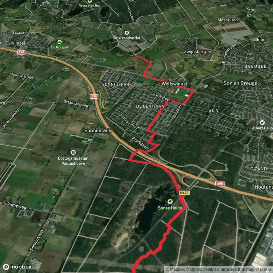
This is a gentle, mostly level walk of about 7 km (4.3 mi) with essentially 0 m (0 ft) of climbing, linking the small hamlet area of Hoberg to Son en Breugel while passing the Oud Meer area—typical Brabant lowland scenery: sandy soils, pine and mixed woodland edges, drainage ditches, and quiet lanes. Expect an easy pace-friendly outing that suits beginners, families, and anyone looking for a low-effort nature break.
Getting to the start (Hoberg area)
Because “Hoberg” is a small locality name used in the Son en Breugel / Best area, the most reliable approach is to aim for a nearby, well-known anchor point and then use HiiKER to snap precisely to the trailhead.
- By car: Navigate toward Son en Breugel (North Brabant, Netherlands) and then follow local signs toward the Hoberg locality. Parking is typically along small public pull-ins near forest edges and rural roads; choose a legal spot that doesn’t block farm access or cycle lanes. If you want a dependable landmark to route to first, aim for Son en Breugel town center (around the Wilhelminaplein / Kerkstraat area) and then drive the short remaining distance to Hoberg using HiiKER for the exact start point.
- By public transport: The easiest public-transport access is usually via Eindhoven (major rail hub). From Eindhoven, regional buses commonly serve Son en Breugel. Get off near the Son en Breugel center stops, then walk or connect by local bus/taxi toward Hoberg. Use HiiKER to confirm the closest stop to your intended start and to avoid adding extra distance.
If you share the start coordinates (lon/lat), I can convert them to the nearest recognizable address or landmark and tighten the transport directions to a specific stop and parking area.
You’ll be walking in a region shaped by centuries of land management: sandy heathlands historically used for grazing and turf cutting, later stabilized and planted with pine, plus a network of small waterways and “meertjes” (ponds) that reflect both natural depressions and human-influenced drainage patterns. Son en Breugel itself sits near the Dommel river system, and the broader area has long been a corridor between villages, farms, and market towns.
What the route feels like underfoot
Over roughly 7 km (4.3 mi), the walking is typically straightforward and flat. Surfaces are commonly a mix of: - Packed dirt / forest track (can be soft after rain) - Gravel or sandy path (a little looser underfoot in dry spells) - Short paved connectors near hamlets and village edges
Because the elevation change is negligible, the main “effort” variables are wind exposure on open stretches and mud/wet patches near low-lying ground and ditches, especially in wetter months.
Segment-by-segment expectations (with landmarks)
0.0–2.0 km (0.0–1.2 mi): Hoberg lanes into woodland edges
You’ll likely start on quiet rural lanes or wide tracks with a mix of hedgerows, small fields, and the first bands of woodland. This is classic Brabant countryside: tidy farm plots, drainage channels, and straight-ish tracks that can feel deceptively similar—good early on to confirm your direction with HiiKER so you don’t drift onto a parallel farm road.
2.0–4.5 km (1.2–2.8 mi): Oud Meer area—lowland water and birdlife
As you approach Oud Meer, the landscape tends to feel a touch more “watery”: ponds, wet hollows, and reedier margins depending on the exact line of the path. Even when the route stays dry, you’ll notice more ditches and damp ground nearby. This is often the most “nature-rich” portion of the walk.
Look and listen for: - Waterfowl and wetland birds (ducks, coots, moorhens; seasonal migrants can appear) - Songbirds along woodland edges - Amphibians in spring around shallow water (watch where you step on narrow paths)
If the path skirts close to the water’s edge, keep an eye out for slippery roots, soft verges, and narrow track pinch points where passing cyclists or other walkers may require a brief step aside.
4.5–7.0 km (2.8–4.3 mi): Transition into Son en Breugel
The final stretch typically shifts from quieter tracks toward more settled edges—expect more signs of village life: smoother surfaces, occasional residential streets, and more frequent crossings with cycle routes. Son en Breugel is well known locally for its green character and proximity to river landscapes; even near town, you often keep a sense of trees and open space rather than dense urban streets.
Navigation and wayfinding (keep it simple)
This is the kind of flat, lowland route where the challenge isn’t steepness—it’s junction density and look-alike tracks. Use HiiKER to: - Confirm you’re on the correct parallel track when multiple paths run side-by-side - Check distances between junctions (helpful in woodland where sightlines are short) - Re-center quickly if you detour around a muddy patch or temporary closure
Nature, wildlife, and what to look out for
- Deer can appear at dawn/dusk along woodland margins; they’re usually shy but can startle you on quiet tracks.
- Ticks are

Surfaces
Asphalt
Unknown
Sand
Wood
Comments and Reviews
User comments, reviews and discussions about the Hoberg to Son en Breugel via Oud Meer, Netherlands.
average rating out of 5
0 rating(s)