
Download
3D Flyover
Add to list
More
684.5 km
38 days
1842 m
Multi Day
“Along the Dutch edge, windswept dunes, dikes, and seaworks create a beautiful, quietly demanding crossing.”
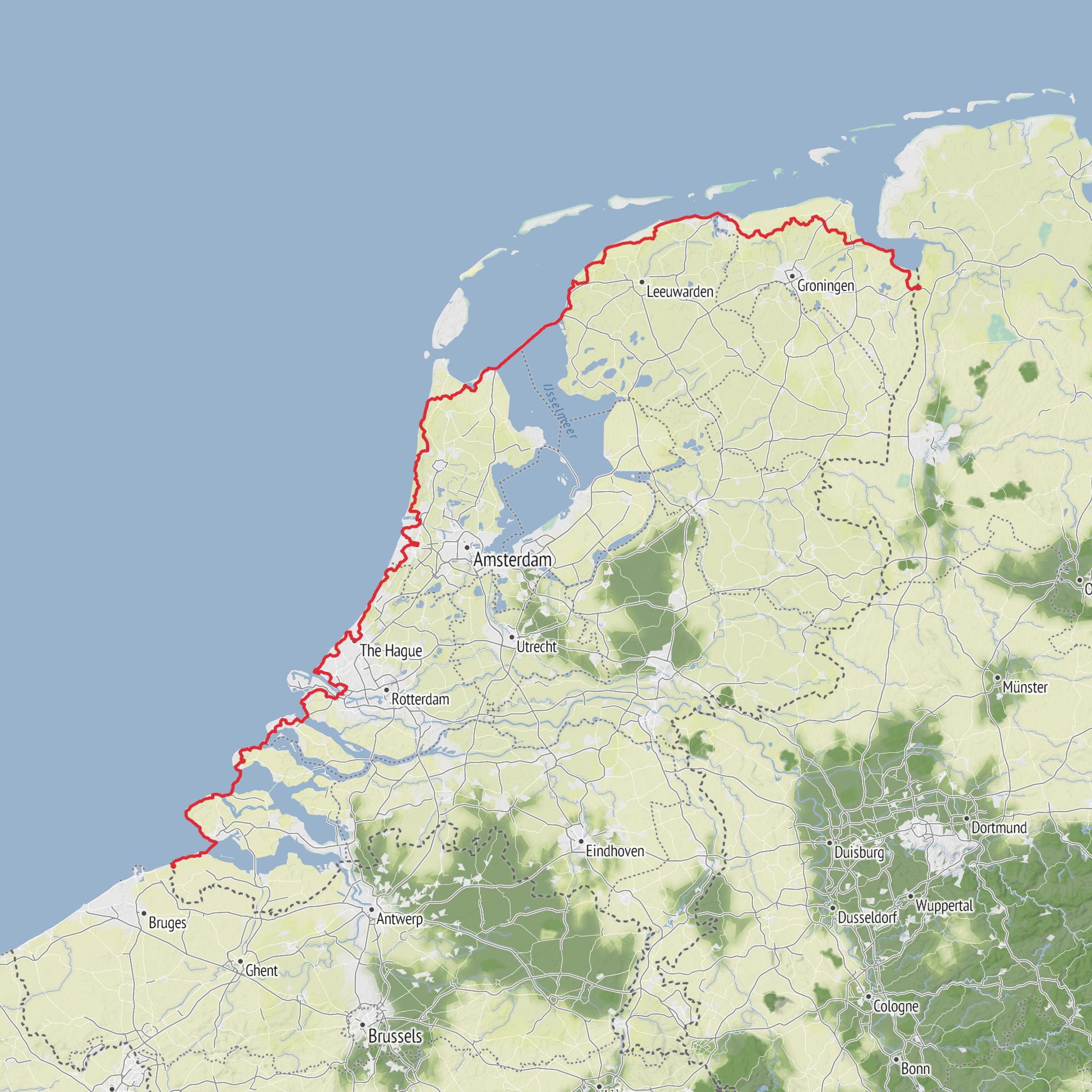
This long Dutch section of the E9 follows the country’s edge where sea, dunes, dikes, estuaries, and engineered coastlines meet. At around 683 km / 424 miles with roughly 1,900 m / 6,230 ft of total ascent, it is best thought of as a low-elevation but very long coastal crossing: physically easier than mountain trails, yet still demanding because of wind exposure, long days, hard dike walking, and repeated stretches of soft sand. The route in the Netherlands broadly aligns with the Nederlands Kustpad / North Sea Trail and runs from the Belgian border at Sluis, Zeeland, through the delta and North Sea coast, then along the Wadden coast toward the German border region. In Dutch route overviews, the E9 in the Netherlands is described as passing through sections including Sluis, Vlissingen, Westkapelle, Veere, Goedereede, Hoek van Holland, Scheveningen, Katwijk, Noordwijk, Haarlem, Egmond aan Zee, Den Helder, Den Oever, and onward along the Wadden side. (nl.wikivoyage.org)
The terrain is overwhelmingly flat, which matches the easy rating, but “easy” here can be misleading. There is very little climbing in the usual sense; instead, the effort comes from cumulative distance, exposed weather, and the constant change between beach, dune tracks, paved promenades, sea walls, and dikes. On the North Sea side, many walkers find the sand and headwinds more tiring than the elevation profile suggests. On the Wadden side, the challenge shifts to long, open embankments and agricultural landscapes where shelter can be limited. The route also includes major water-engineering corridors, with more than 50 km / 31 miles of sea dikes in some descriptions, including the Afsluitdijk, a 32 km / 20 mile barrier between North Holland and Friesland. (nl.wikivoyage.org)
If you are planning the hike end-to-end, it helps to think of it in four broad landscape bands: the Zeeland delta, the South and North Holland dune coast, the Afsluitdijk crossing, and the Wadden coast of Friesland and Groningen. Each has a different feel, different logistics, and different hazards.
Coast, dunes, and delta landscapes
The southern part near Sluis begins close to the Belgian border in a landscape shaped by estuaries, reclaimed land, and old trading routes. Sluis itself is the nearest clear trailhead landmark from the information available, and it is a practical reference point for transport and accommodation. From there, the route moves through Zeeland’s coastal world of dikes, inlets, beaches, and storm-surge infrastructure. Expect broad skies, tidal water, and a strong sense that this is a country built in negotiation with the sea. The line through Breskens, Vlissingen, Westkapelle, Veere, and Burg-Haamstede brings together resort coast, old harbor towns, and some of the Netherlands’ most important flood-defense landscapes. (nl.wikivoyage.org)
One of the most significant landmarks in this southern section is the Delta Works area around Neeltje Jans. These structures were built to reduce the risk of another catastrophe after the 1953 North Sea flood disaster, and Neeltje Jans sits beside the storm-surge barrier as one of the most visible places to understand that history. For hikers, this means a striking contrast: wild-looking sea and wind on one side, and some of the most ambitious hydraulic engineering in Europe on the other. (neeltjejans.nl)
Farther north, the route through Hoek van Holland, Scheveningen, Katwijk, Noordwijk, Zandvoort, the Kennemer dunes, Egmond aan Zee, Bergen aan Zee, Schoorl, Den Helder, and Den Oever is the classic Dutch coastal walking experience. This is where many hikers picture the E9 in the Netherlands: long beaches, marram-grass dunes, boardwalks, seaside towns, and frequent access to food and lodging. The central coastal section from Hoek van Holland to Den Helder alone is about 233 km / 145 miles, and although it gains only about 200 m / 656 ft in total, it can feel harder than expected because of soft sand and exposure. (hikelist.com)
Nature and wildlife
The wildlife changes noticeably as the route moves north. In the dune systems, expect typical coastal birdlife such as gulls,
AI Planner
Days planned around your pace, with somewhere to stay each night.
Surfaces
Unknown
Asphalt
Grass
Concrete
Dirt
Gravel
Paved
Sand
Wood
Comments and Reviews
User comments, reviews and discussions about the E9 Netherlands, Netherlands.
average rating out of 5
0 rating(s)



