Download
3D Flyover
Add to list
More
16.3 km
~3 hrs 23 min
78 m
Loop
“Drift from pine shade to wind-sculpted heath on Schoorl’s sandy loop, where soft footing can surprise.”
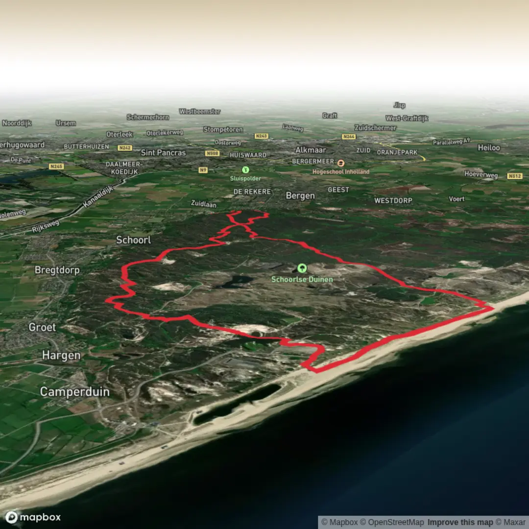
A sandy, low-elevation loop through the Schoorlse Duinen (Schoorl Dunes) area where the “climbs” are short, rolling dune rises rather than long hills. Over ~16 km (about 10 miles) with roughly 100 m (about 330 ft) of total ascent, expect a mostly easy day that can feel more demanding if it’s windy, hot, or the sand is loose underfoot.
Getting to the start (car + public transport)
Best start area: the village of Schoorl (North Holland, Netherlands)—most hikers begin near the main access points to the dunes around Schoorl’s village center and the dune entrance by the Klimduin (the famous climbable dune in town). If you’re aiming for the most straightforward logistics, plan to start/finish near Klimduin, Schoorl (a prominent landmark and common meeting point).
- By car: Drive to Schoorl and park in one of the public car parks near the village center/Klimduin area. Arrive earlier on weekends and sunny days—this is a popular coastal-dune destination and parking can fill quickly.
- By public transport: The most typical approach is train to Alkmaar, then a bus toward Schoorl (routes vary by season and operator). From the bus stop in/near Schoorl center, it’s usually a short walk to the dune access points.
If you share the exact start coordinates (lon/lat), I can pin it to the nearest named place (street, car park, bus stop, or landmark) and describe the first turns precisely.
What the terrain is like (and what that means for planning) - Underfoot: A mix of compact sandy paths, softer dune sand, and forest tracks. Even on an “easy” profile, soft sand can slow pace and increase effort—budget extra time compared with a firm gravel trail. - Exposure: Dune tops and open heath can be windy with little shelter. In summer, sun exposure can be significant; in cooler months, wind chill is the main factor. - Footwear: Trail shoes are usually fine; if it’s been wet, some low areas can be damp, but this region is more about sand than mud. - Navigation: Trails braid and intersect frequently in the dunes. Load the route in HiiKER and keep an eye on junction density—many paths look equally “main.”
Route flow and key points along the loop You’ll typically begin on easy access tracks leaving Schoorl, quickly transitioning into the dune landscape. The loop links two distinct feels: pine/deciduous woodland shelter and open dune/heath corridors where the horizon widens and the footing becomes sandier.
0–3 km (0–1.9 mi): Settling in through dune-edge woodland The opening kilometers are usually the most straightforward: wider paths, gentler grades, and more tree cover. This is where you’ll find your rhythm and confirm your navigation setup in HiiKER. Elevation change is minimal here—small undulations rather than sustained climbing.
3–8 km (1.9–5 mi): Schoorlsche Nok area—rolling dune rises As you angle toward Schoorlsche Nok, the trail tends to become more “dune-like”: narrower sandy tracks, short punchy rises, and occasional viewpoints over the dune system. None of the climbs are long, but you may stack several small ascents close together. This is where most of the loop’s ~100 m (330 ft) gain is accumulated in little increments.
Look out for: - Wind-sculpted dune forms and shifting sand edges along the path - Heath and scrub patches (seasonal color changes can be striking) - Trail braids: multiple parallel footpaths—stay attentive to your HiiKER line at junction clusters
8–12 km (5–7.5 mi): Transition toward Bregtdorp—quieter tracks and open stretches The middle of the loop often feels calmer and more spacious. You may pass near or toward Bregtdorp, a small rural hamlet area where the landscape can open up and the trail may flirt with the dune boundary. Expect a mix of sandy singletrack and firmer connectors.
This is a good section to plan a short break: it’s far enough in to justify a pause, and you’ll want to check hydration—wind and sand can be deceptively drying even in mild temperatures.
12–16 km (7.5–10 mi): Return leg—forest shelter back toward Schoorl The final quarter typically brings you back into more sheltered woodland tracks and easier footing. If you’ve been battling soft sand earlier, this can feel noticeably faster. Keep an eye out for cyclists on shared paths—this region has a strong outdoor culture and multi-use routes are common.
Nature and wildlife to expect This area is part of a classic Dutch coastal-dune ecosystem: - Vegetation: dune grasses stabilizing sand, heathland patches, and extensive pine woodland planted historically to help manage drifting sands. - Birdlife: songbirds in the woods; in open dune/heath, you may see raptors riding the wind. - Mammals: small mammals are common but often unseen; deer can occur in dune landscapes in the broader region, though sightings vary by season and time of day.
Stay on established paths where required—dune habitats are sensitive, and restoration areas may be signed.
Landmarks and regional context (why this place looks the way it does) The Schoorl dunes are among the highest and widest dune systems in the Netherlands, shaped by coastal winds and long-term sand movement. Human management—plant

Surfaces
Sand
Unknown
Asphalt
Unpaved
Concrete
Gravel
Comments and Reviews
User comments, reviews and discussions about the Schoorlsche Nok and Bregtdorp Loop, Netherlands.
average rating out of 5
0 rating(s)