Download
3D Flyover
Add to list
More
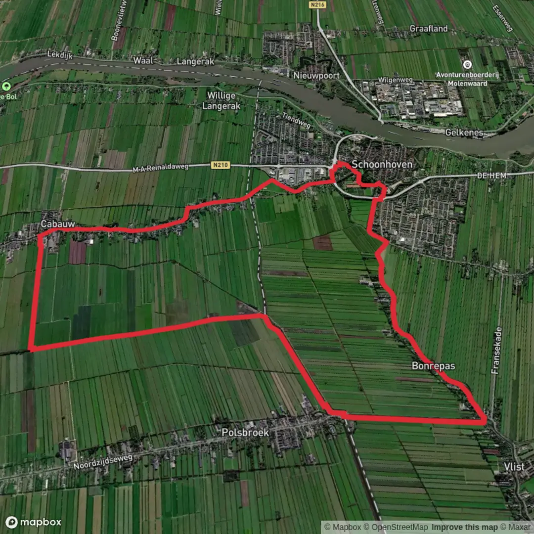
14.8 km
~2 hrs 57 min
0 m
Loop
“A gentle, level countryside loop of lanes and hedgerows, where mud and breeze shape the mood.”
A flat, easy-going loop of roughly 15 km (9.3 miles) with essentially 0 m (0 ft) of climbing, this walk is best planned as a steady half-day outing where the main “effort” is distance rather than elevation. Expect a mix of quiet lanes, field edges, and lowland paths where conditions underfoot can change quickly after rain—mud and standing water are often the biggest obstacles on terrain this level.
Getting to the start (car + public transport)
Because the start point is listed only as “near” (with no coordinates or place name), the most reliable way to pin down the exact trailhead is to open the route in HiiKER and use its start-point map to identify the nearest road access and parking. Once you share a lon/lat (or a HiiKER link), I can convert it to the nearest known address/landmark and tailor directions precisely.
In the meantime, here’s how to plan access for a typical lowland loop like this:
- By car: Look for a small village-edge pull-in, a signed public footpath access, or a community car park (often near a church, village hall, or sports field). Arrive with a backup parking option in mind—flat agricultural areas can have limited legal parking, and verges may be soft.
- By public transport: If there’s a nearby village or small town on a bus line, aim to arrive at the closest stop to the loop and walk a short connector to the start. For rural routes, check return times before you set off; services can be infrequent, especially on weekends.
What the route feels like underfoot
With negligible elevation gain, the loop tends to be rhythmical: long, level stretches where you can settle into a pace. The tradeoff is that surface conditions matter more than gradients:
- After wet weather: expect slick grass, muddy gateways, and puddled tractor ruts. Waterproof footwear is often more useful than trekking poles on a route like this.
- In dry spells: paths can firm up, but you may still encounter uneven ground where field margins have been churned up.
- Wind exposure: flat country can be surprisingly breezy with little shelter—pack a light wind layer even if the forecast looks mild.
Navigation is usually straightforward on a loop, but lowland path networks can be dense and signage inconsistent. Keep HiiKER handy for confirming junctions, especially where multiple tracks run parallel along field edges.
Landmarks, landscape, and the “big views” (without the climb)
On a flat loop, the highlights are often subtle and rewarding if you know to look for them:
- Field-edge corridors and hedgerows: These act like wildlife highways. You’ll often see seasonal changes clearly—spring blossom, summer growth, autumn berries, and winter silhouettes.
- Drainage ditches, canals, or small streams (where present): Even minor watercourses can be the most “alive” parts of a lowland walk, drawing birds and amphibians.
- Farm architecture and rural lanes: Expect working countryside—gates, stiles, and occasional short road sections linking rights of way.
If the loop passes near any named features (a mill, church, manor, canal, or nature reserve), share the start location or a HiiKER route link and I’ll call out those landmarks with approximate distances along the circuit.
Nature and wildlife to look out for
Flat, mixed farmland and lowland paths commonly support a lot of edge-habitat wildlife:
- Birdlife: Hedgerows and open fields can produce raptors overhead and small birds flitting between cover. Near water, watch for waterfowl and waders depending on season.
- Mammals: You may spot deer at field margins early/late in the day, and smaller mammals using hedgerow cover.
- Insects and wildflowers: In warmer months, sunny verges and field margins can be rich with pollinators—especially where hedges are thick and flowering plants are left to grow.
A practical note: in agricultural areas, livestock may be present. Give animals space, keep dogs under close control, and move calmly through fields.
Hazards and practical planning (easy doesn’t mean effortless)
Even with 0 m (0 ft) of ascent, a 15 km (9.3 mile) loop benefits from a little planning:
- Time estimate: Many hikers will take 3–4 hours depending on stops and ground conditions.
- Footwear: Prioritize grip and water resistance over ankle support for a route like this.
- Road crossings and short lane sections: Stay alert for fast-moving local traffic on narrow roads with limited verges.
- Seasonal issues:
- Winter: waterlogged ground, short daylight.
- Spring: softer paths, occasional flooding in low spots.
- Summer: sun exposure and heat on open stretches.
- Autumn: slippery leaves on shaded lanes and muddy gateways.
- Winter: waterlogged ground, short daylight.
Historical significance (what to watch for)
Without the exact region pinned down, the most likely historical threads on a lowland European-style loop (often associated with place names like “Schoonhoven”) include:
- Old settlement patterns: villages clustered on slightly higher, drier ground with fields radiating outward.
- Water management history: ditches, embankments, and straightened channels can reflect centuries of drainage and land-use engineering.
- Agricultural heritage: long-established field boundaries and historic farmsteads can hint at older land divisions.
If you provide the lon/lat for the start (or the HiiKER route), I can

Surfaces
Asphalt
Unknown
Cobblestone
Wood
Comments and Reviews
User comments, reviews and discussions about the Schoonhoven Loop, Netherlands.
average rating out of 5
0 rating(s)