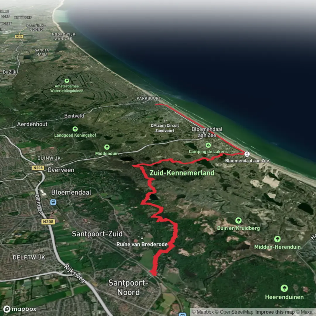
Santpoort Noord to Zandvoort aan zee via Brederodeberg and Vogelmeer
Download
3D Flyover
Add to list
More
15.6 km
~3 hrs 11 min
40 m
Point-to-Point
“From Santpoort Noord to Zandvoort’s surf, wander dune ripples and hushed bird wetlands—weather-permitting.”
Starting near Santpoort Noord railway station (a practical landmark for meeting up and resupplying), this easy, mostly flat-to-gently-rolling walk links village edges, dune ridges, and wetland bird habitat before finishing at the North Sea beachfront in Zandvoort aan Zee. Although the overall elevation gain is often described as “around 0 m,” expect small, frequent undulations on dune paths—nothing sustained, but enough to notice underfoot.
- Distance: ~16 km / ~10.0 miles
- Total ascent: ~0 m stated (realistically: minor dune ups/downs)
- Difficulty: Easy (longer half-day walk; surfaces vary)
Getting to the start (Santpoort Noord)
By train (public transport):
Santpoort Noord has its own NS rail station (Station Santpoort Noord) with straightforward connections via Haarlem. From the platforms you’re immediately in a quiet residential area with quick access to paths leading toward the dunes and estates.
By car:
Aim for parking near Station Santpoort Noord (station-area streets and small local parking pockets). Arrive early on weekends—this region draws walkers and cyclists, and parking fills faster in good weather.
Navigation:
Load the route in HiiKER before you arrive. Mobile signal is usually fine around towns, but can be patchier in dune hollows and wooded pockets.
From the station area, you’ll leave the built-up streets quickly and begin threading toward the dune landscapes that separate inland North Holland from the sea. The first few kilometers are typically on firm paths and quiet lanes, good for warming up and settling into a steady pace.
As you approach the dune zone, the terrain changes: sandy soils, pine and scrub, and occasional open viewpoints. Even on an “easy” route, this is where footing can become looser and more energy-demanding—sand can slow you down, especially if it’s dry and churned up.
Brederodeberg and the estate landscape (approx. km 4–7 / mile 2.5–4.3)
Around the mid-first half of the hike you’ll pass the area known as Brederodeberg—not a mountain in the alpine sense, but a dune rise that gives a subtle sense of height and a change in perspective over the surrounding woodland and dune scrub. This section is often the most “textured” underfoot: a mix of compacted sand, rooty woodland track, and short climbs/descents.
Nearby, the region’s identity is strongly shaped by historic estates and country properties that once took advantage of the healthy dune air and proximity to Haarlem/Amsterdam trade routes. The name “Brederode” is closely tied to the medieval noble family and the broader history of fortified sites and estates in this part of North Holland. Even when you’re not directly at a castle complex, the managed woodland, long straight tracks, and old boundary lines hint at centuries of land use and stewardship.
What to look out for here
- Sandy patches: shoes with decent tread help; gaiters are optional but can be nice in very dry conditions.
- Cyclists: many shared paths; keep right and be predictable when stepping aside.
- Wind exposure: dune crests can be breezy even when inland areas feel calm.
Vogelmeer wetlands and birdlife (approx. km 7–11 / mile 4.3–6.8)
The route’s character shifts again as you near Vogelmeer (“Bird Lake”), a wetland area that’s especially rewarding if you pause quietly. Expect reedy margins, open water, and damp meadow edges, with a noticeably different soundscape—more birdsong and waterfowl calls, less traffic.
Wildlife you may see (season-dependent)
- Waterfowl such as ducks, geese, and swans on open water
- Waders and marsh birds along reedbeds (listen for calls before you spot them)
- Raptors overhead, using dune-edge thermals and open wetland hunting grounds
This is a good place to slow down and keep voices low. If there are viewing points or benches, they’re worth using—birds often stay farther out on the water, and a still pause increases what you’ll notice.
Practical notes
- Mud after rain: even if the overall hike is “flat,” wetland-adjacent paths can become slick.
- Insects in warm months: consider repellent in late spring/summer, especially near still water.
- Stay on marked paths: sensitive habitat and occasional seasonal restrictions are common in Dutch dune and wetland reserves.
After Vogelmeer, you’ll gradually transition from inland dune reserve feel toward the coastal town edge. The last third of the hike tends to be more open and wind-influenced, with the air taking on a salty edge as you near the sea.
Approaching Zandvoort and the North Sea finish (approx. km 11–16 / mile 6.8–10.0)
As you close in on Zandvoort aan Zee, surfaces often become more consistently firm again—wider tracks, occasional paved segments, and clearer wayfinding as you approach town infrastructure. You’ll likely notice more day visitors, especially on weekends and sunny days.
Finishing at the beachfront is a satisfying contrast to the earlier woodland and wetland sections: wide skies, strong coastal light, and the sound of surf. If you’re planning logistics, Zandvoort aan Zee station is a convenient end-point landmark for returning by train, and the town has plenty of options for water, food, and

Surfaces
Sand
Unknown
Unpaved
Ground
Asphalt
Gravel
Paved
Concrete
Comments and Reviews
User comments, reviews and discussions about the Santpoort Noord to Zandvoort aan zee via Brederodeberg and Vogelmeer, Netherlands.
average rating out of 5
0 rating(s)