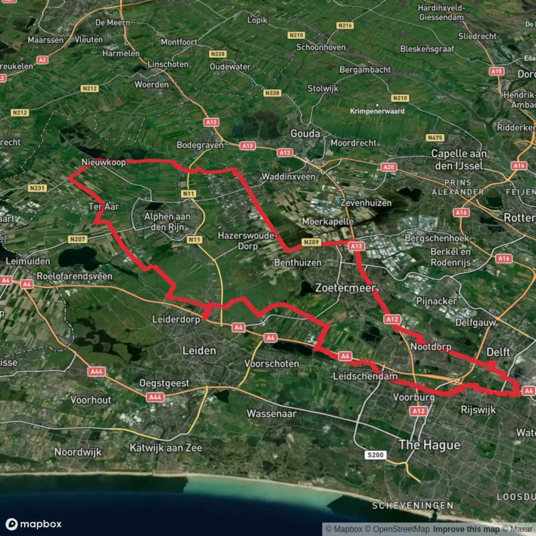
Plaspoelpolderpad, Houtzaagmolenpad, Westvlietweg, Duinwaterpad and Gravenpad
Download
3D Flyover
Add to list
More
98.7 km
~4 days
0 m
Multi-Day
“A wind-swept ribbon of canals, polders, and dune-waters—flat, bright, and quietly demanding.”
This is a long, low-lying loop/through-hike of roughly 99 km (61.5 miles) with essentially 0 m (0 ft) of climbing, linking a chain of paved and hard-packed paths and quiet roads through polders, canals, suburban edges, and dune-water landscapes. Expect a “big day(s) out” that’s physically straightforward (no hills) but can be demanding on feet and pacing because the terrain is so consistently flat and often exposed to wind.
Because your start point is listed only as “near” (no coordinates provided), I can’t reliably convert the start lon/lat to a specific nearby address or landmark yet. If you paste the start coordinates (or a GPX), I’ll pin it to the nearest recognizable place (e.g., a station, bridge, windmill, or trailhead) and tailor the access directions precisely.
Getting to the start (general, works well for this corridor)
- By public transport: This route name set strongly suggests the The Hague (Den Haag) / Leidschendam–Voorburg / Westland / Delft area in the Netherlands—an area with dense rail/tram/bus coverage. A practical approach is to arrive by train at a major hub such as Den Haag Centraal or Delft and then use local tram/bus to the nearest stop to your chosen trailhead. Once you share the exact start point, the best stop is usually within a short walk because these paths often run close to neighborhoods and canal roads.
- By car: Driving is straightforward, but parking can be the limiting factor. In this region, the most reliable all-day parking tends to be at park-and-ride lots, larger recreation areas, or near industrial edges rather than tight residential streets. If your hike is point-to-point, plan a return via train/tram; if it’s a loop, choose a trailhead near a station so you have a backup exit.
Bring HiiKER for turn-by-turn confidence: in flat polder country, many junctions look similar, and it’s easy to follow the “right-looking” canal path that’s actually one canal over.
What the terrain feels like (and why it matters)
You’ll be moving through classic Dutch polder infrastructure: straight canal lines, dikes, drainage channels, and service roads. Underfoot is typically: - Asphalt cycle paths and brick/paver paths near towns - Hard-packed gravel or dike-top tracks in open polder sections - Occasional short grassy verges or muddy edges after rain, especially where maintenance vehicles have churned shoulders
Even with negligible elevation gain, the “difficulty” can change quickly with: - Wind exposure: long, treeless canal corridors can turn a flat day into a grind. - Surface repetition: 99 km (61.5 miles) of firm, flat surface can stress shins/feet if footwear is too minimal. - Navigation monotony: many straight segments and repeated bridge/canal patterns—easy to drift off-route without noticing.
Route character by segments (approximate breakdown)
Because the named paths read like a stitched chain, a sensible way to plan is in 5 chunks of ~18–22 km (11–14 miles) each. Adjust once your exact start point is known.
1) Plaspoelpolderpad — polder edge walking (≈18–22 km / 11–14 miles)
This section is typically defined by wide skies, reed-lined water, and industrial/suburban margins. “Plaspoelpolder” refers to reclaimed lowland—expect: - Long straightaways beside drainage canals - Frequent bike traffic on shared paths (keep right, be predictable) - Birdlife in the reeds: coots, moorhens, mallards, grey herons, and often geese in open fields
Look out for narrow bridges and underpasses where cycle routes funnel—these are the few places you’ll need to slow down and be deliberate.
2) Houtzaagmolenpad — waterworks and windmill heritage (≈18–20 km / 11–12.5 miles)
“Houtzaagmolen” translates to sawmill windmill, a reminder that this region’s landscape was shaped by wind-powered industry and water management. Even if the original mill isn’t directly on your line, the theme is consistent: mills, pumping stations, and engineered waterways.
What to expect: - More canal junctions and sluice-like structures - Occasional interpretive signage about local water control - A mix of quiet residential edges and open polder
Wildlife tends to be most visible early/late: swans, lapwings (seasonal), and raptors like kestrels hovering over fields.
3) Westvlietweg — historic corridor feel (≈18–22 km / 11–14 miles)
“Westvliet” points to the Vliet waterway area, historically important as a transport and settlement corridor between older towns and cities. Even without big “monuments,” the history is in the layout: - Linear roads tracking waterways (old movement routes) - Older farm plots and long-established dike lines - A steady rhythm of bridges and waterside homes/boatyards
Practical notes: - This is often one of the most straightforward navigation legs (follow the water/road line), but also one where you can rack up distance quickly without many natural breaks—plan stops intentionally. - Watch for fast commuter cyclists on the best-surf

Surfaces
Asphalt
Unknown
Wood
Gravel
Paved
Comments and Reviews
User comments, reviews and discussions about the Plaspoelpolderpad, Houtzaagmolenpad, Westvlietweg, Duinwaterpad and Gravenpad, Netherlands.
average rating out of 5
0 rating(s)